Area Overview for B29 7RR
Photos of B29 7RR
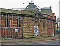
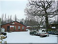
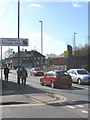
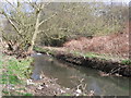

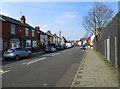
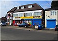
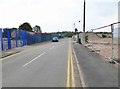
100 photos from this area
Area Information
Key information about the B29 7RR including its size, population, and administrative classification.
- Area Type
- Postcode
- Area Size
- 4136 m²
- Population
- 1546
- Population Density
- 7118 people/km²
House Prices in B29 7RR
24
Properties
£123,122
Average Sold Price
£45,950
Lowest Price
£192,500
Highest Price
Showing 24 properties
| Address | Type | Beds | Baths | Last Sale Price | Last Sale Date | |
|---|---|---|---|---|---|---|
| 41 St Stephens Road, Birmingham, B29 7RR | Terraced | 2 | 1 | £192,500 | Sep 2023 | |
| 19 St Stephens Road, Birmingham, B29 7RR | Terraced | 1 | 1 | £190,000 | Feb 2023 | |
| 11 St Stephens Road, Birmingham, B29 7RR | Terraced | 1 | 9 | £174,000 | Sep 2020 | |
| 9 St Stephens Road, Birmingham, B29 7RR | Terraced | 1 | 20 | £156,000 | Jul 2019 | |
| 33 St Stephens Road, Birmingham, B29 7RR | Terraced | 2 | 1 | £147,000 | Sep 2018 | |
| 17 St Stephens Road, Birmingham, B29 7RR | Terraced | 2 | 1 | £150,000 | Feb 2018 | |
| 35 St Stephens Road, Birmingham, B29 7RR | Terraced | 2 | 1 | £122,000 | Oct 2014 | |
| 31 St Stephens Road, Birmingham, B29 7RR | Terraced | 2 | 1 | £97,550 | May 2014 | |
| 29 St Stephens Road, Birmingham, B29 7RR | Terraced | 2 | 1 | £109,000 | Jan 2014 | |
| 45 St Stephens Road, Birmingham, B29 7RR | Terraced | 3 | 2 | £95,000 | Jul 2011 |
Page 1 of 3
Energy Efficiency in B29 7RR
Amenities
Schools
| Rank | School | Type | Entry gender | Ages |
|---|
Explore more schools in this area
Go to Schools tabDemographics
Household Size
Family (3-5 people)
most common
Accommodation Type
Houses
most common
Tenure
58
majority
Ethnic Group
White
most common
Religion
N/A
most common
Household Composition
N/A
most common
Age
47
median
Adults (30-64 years)
most common
Household Deprivation
N/A
with no deprivation
NS-SEC
31
in Lower managerial occupations
Explore more demographic insights in this area
Go to Demographics tabPlanning
Planning Constraints
- Flood RiskPremium
- Ramsar Wetland SitesPremium
- Area of Outstanding Natural BeautyPremium
- Protected Nature ReservePremium
- Protected WoodlandPremium