Area Overview for B11 1ED
Photos of B11 1ED


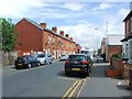
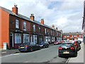
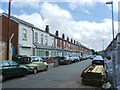
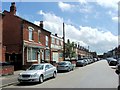
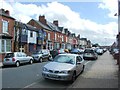
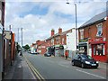
67 photos from this area
Area Information
Key information about the B11 1ED including its size, population, and administrative classification.
- Area Type
- Postcode
- Area Size
- 1.1 hectares
- Population
- 2832
- Population Density
- 12615 people/km²
House Prices in B11 1ED
46
Properties
£80,643
Average Sold Price
£25,500
Lowest Price
£115,000
Highest Price
Showing 46 properties
| Address | Type | Beds | Baths | Last Sale Price | Last Sale Date | |
|---|---|---|---|---|---|---|
| 37 Grace Road, Birmingham, B11 1ED | house | - | - | £100,000 | Feb 2025 | |
| 27 Grace Road, Birmingham, B11 1ED | house | - | - | £65,000 | Nov 2010 | |
| 25 Grace Road, Birmingham, B11 1ED | house | - | - | £115,000 | Jul 2006 | |
| 19 Grace Road, Birmingham, B11 1ED | house | - | - | £99,000 | Mar 2006 | |
| 33 Grace Road, Birmingham, B11 1ED | Terraced | - | - | £80,000 | Aug 2004 | |
| 15 Grace Road, Birmingham, B11 1ED | Terraced | 2 | 1 | £80,000 | Jun 2004 | |
| 29 Grace Road, Birmingham, B11 1ED | house | - | - | £25,500 | Apr 2003 | |
| 88-92 GRACE ROAD, Birmingham, B11 1ED | Semi-detached | - | - | - | - | |
| 28 Grace Road, Birmingham, B11 1ED | Terraced | - | - | - | - | |
| 18 Grace Road, Birmingham, B11 1ED | house | - | - | - | - |
Page 1 of 5
Energy Efficiency in B11 1ED
Amenities
Schools
| Rank | School | Type | Entry gender | Ages |
|---|
Explore more schools in this area
Go to Schools tabDemographics
Household Size
Family (3-5 people)
most common
Accommodation Type
Houses
most common
Tenure
54
majority
Ethnic Group
asian_total
most common
Religion
N/A
most common
Household Composition
N/A
most common
Age
22
median
Adults (30-64 years)
most common
Household Deprivation
N/A
with no deprivation
NS-SEC
10
in Lower managerial occupations
Explore more demographic insights in this area
Go to Demographics tabPlanning
Planning Constraints
- Flood RiskPremium
- Ramsar Wetland SitesPremium
- Area of Outstanding Natural BeautyPremium
- Protected Nature ReservePremium
- Protected WoodlandPremium