Area Overview for B10 0PG
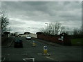
Photos of B10 0PG
Area Information
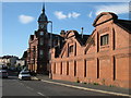
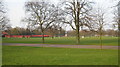
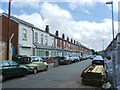
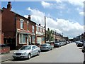
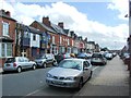
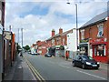
Bordesley Green represents a distinct inner-city neighbourhood within Birmingham, centred around the B10 0PG postcode. This small residential cluster occupies just 2477 square metres yet houses 1899 people, creating a tightly knit community structure. The area derives its name from an ancient demesne pasture first recorded in 1285, though significant urban development did not begin until 1834. A defining feature of the locality is the Ideal Village, constructed between 1908 and 1914 by architects Barry Parker and Raymond Unwin. This development was England's first aimed at artisan workers, featuring lower-density housing, shops, a park, and a school. The history of the ward reflects resilience; residents endure a past marked by five Blitz raids, including the last German bomb on Birmingham on 24 April 1943. Today, the area retains notable features such as a surviving early 20th-century fire station and police station currently used as a hostel. St Paul's Church, built in 1912 and consecrated as a parish church in 1929, anchors the local community. Living in B10 0PG means engaging with a place where history intertwines with modern urban life, situated about two miles east of the city centre within the West Midlands region.
- Area Type
- Postcode
- Area Size
- 2477 m²
- Population
- 1899
- Population Density
- 5465 people/km²
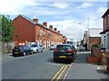
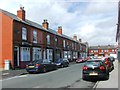
The housing market in B10 0PG presents a landscape dominated by rental living rather than owner-occupancy. Data confirms that just 28% of residents owner-occupy their homes. This low figure indicates a robust private rental sector which characterises the area's property dynamics. The primary accommodation type consists of houses, a stark contrast to the high-rise blocks often associated with inner-city Birmingham. This suggests a stock of older housing, potentially comprising the houses within the Ideal Village or other 20th-century developments. For you, a homebuyer looking at this specific postcode, the implication is that available homes may compete for attention within a market where tenants often outnumber owners. The area's small footprint of 2477 square metres limits the volume of available listings, meaning choices are likely presented on a first-come, first-served basis rather than a broad, lingering open market. Understanding this balance between rentals and sales is essential when considering homes here versus in adjacent suburbs with higher ownership percentages.
House Prices in B10 0PG
No properties found in this postcode.
Energy Efficiency in B10 0PG
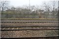
Your daily life in B10 0PG is supported by a range of amenities located within practical reach. Retail needs are met by five notable convenience stores, including Morrisons Bordesley, Iceland Birmingham, and Spar City, ensuring access to groceries and everyday essentials. Five railway stations, such as Bordesley and Adderley Park, provide immediate rail access for commutes, while five metro points like Grand Central New Street connect you directly to the wider city centre. The area reflects its historical roots with surviving landmarks like the Ideal Village, which originally featured its own shops when built between 1908 and 1914. While some original operational features have changed, such as the fire station now being a hostel, the physical layout remains intact. You can access these historic paths and local character through designated community projects, including those around St Paul's Church in Belchers Lane. This blend of modern retail convenience and historic neighbourhood charm defines the local lifestyle.
Amenities
Schools
Families considering B10 0PG have access to a varied mix of educational institutions nearby. The nearest state sector option is Regents Park Community Primary School, which holds a Good Ofsted rating. For post-primary education, independent options include the Eden School of Accountancy and Oakwood School (BIETTEC), both of which outside of standard state inspection categories offer alternative curricula. Green Heath School also operates as an independent institution with a Good Ofsted rating. Special needs requirements can be met through Blue River Academy, a special school serving the wider area. This combination provides a structured choice for parents, blending strong state provision with access to private independent schools and specialist support. The presence of these diverse institutions near the area suggests a environment where families can find schools matching specific educational philosophies or support needs without travelling far from their residences in B10 0PG.
| Rank | School | Type | Entry gender | Ages |
|---|
Explore more schools in this area
Go to Schools tabDemographics
The population profile of B10 0PG indicates a mature community with a median age of 47 years. Most residents fall into the adult bracket, spanning from 30 to 64 years old. Household composition leans significantly towards renting, with only 28% of residents owning their homes outright. The remaining 72% of the population resides in rented accommodation. This contrasts sharply with many suburban areas where home ownership typically dominates. Accommodation types are predominantly houses, suggesting a stock that likely includes terraced or semi-detached properties typical of early 20th-century developments. The ethnic makeup of the area is diverse, with the Asian group being the predominant ethnicity. These demographic facts define the daily rhythm of the neighbourhood, reflecting a population that has seen the ward evolve from its origins in Small Heath and Sparkbrook into a distinct community within the Bordesley Green Ward.
Household Size
Accommodation Type
Tenure
Ethnic Group
Religion
Household Composition
Age
Household Deprivation
NS-SEC
Explore more demographic insights in this area
Go to Demographics tabPlanning
Planning Constraints
- Flood RiskPremium
- Ramsar Wetland SitesPremium
- Area of Outstanding Natural BeautyPremium
- Protected Nature ReservePremium
- Protected WoodlandPremium