Area Overview for B10 0QL
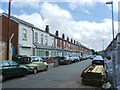
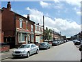
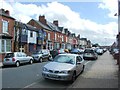
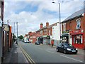
Photos of B10 0QL


Area Information
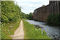
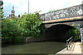
B10 0QL is a small residential cluster in Birmingham, England, with a population of 1,899. Situated about two miles east of the city centre, it lies within the West Midlands region, centred on coordinates 52.470013, -1.872136. The area has a layered history, from its medieval origins as *La Grene de Bordeslei* to urban development beginning in 1834. Notable landmarks include the Ideal Village, a pioneering 20th-century housing project with low-density homes, shops, and a park, and St Paul’s Church, which dates back to 1912. Daily life here is shaped by its proximity to transport hubs like Bordesley Railway Station and a mix of retail outlets, including Morrisons and Spar. The area’s compact size means residents are close to amenities, though its character is defined by a blend of historic infrastructure and modern living. With a median age of 47 and a population skewed toward adults aged 30–64, the community reflects a settled, family-oriented demographic. Living in B10 0QL offers a balance of urban convenience and historical interest, though its small size means it is best suited for those prioritising accessibility over expansive space.
- Area Type
- Postcode
- Area Size
- Not available
- Population
- 1899
- Population Density
- 5465 people/km²
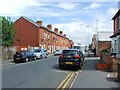
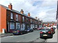
B10 0QL’s property market is characterised by a low home ownership rate of 28%, suggesting that the area is more reliant on rental properties than owner-occupied homes. The accommodation type is predominantly houses, which is notable in a city-centre postcode. This mix indicates a potential niche for buyers seeking larger, family-friendly homes, though the limited number of owner-occupied properties may reflect challenges in affordability or investment opportunities. The small size of the area means that the housing stock is concentrated, with limited scope for expansion. For buyers, this implies that properties here are likely to be older, with historical features from the Ideal Village era, but may require modernisation. The proximity to transport links and amenities could make it attractive to those prioritising convenience over space, though the low home ownership rate suggests competition for available properties. Buyers should consider the area’s compact nature and the potential for a rental-focused market when evaluating opportunities.
House Prices in B10 0QL
No properties found in this postcode.
Energy Efficiency in B10 0QL
Living in B10 0QL offers a range of amenities within walking or short transport distance. The area is served by five retail outlets, including Morrisons Bordesley and Spar City, providing access to groceries and everyday essentials. Nearby railway stations like Bordesley and Small Heath connect residents to Birmingham’s broader retail and entertainment hubs. The presence of metro stations such as Corporation Street and Bull Street further enhances mobility, linking to cultural and commercial centres. Parks and open spaces are less explicitly detailed, but the legacy of the Ideal Village suggests historical green spaces may still be accessible. The mix of retail, transport, and community infrastructure contributes to a convenient lifestyle, though the area’s small size means it is best suited for those prioritising proximity to services over expansive recreational facilities. The character of B10 0QL is defined by its compact, walkable environment, where daily needs are met without the need for long commutes.
Amenities
Schools
Residents of B10 0QL have access to a range of schools, including Regents Park Community Primary School, which holds a ‘good’ Ofsted rating. For independent education, Eden School of Accountancy and Oakwood School (BIETTEC) offer alternative options, though their specific focus is not detailed in the data. Green Heath School, another independent institution, also carries a ‘good’ Ofsted rating, adding to the diversity of educational choices. Blue River Academy is a special school, catering to students with specific needs. This mix of primary, independent, and special schools provides families with multiple pathways, from state-funded education with a strong rating to private institutions. However, the absence of secondary schools in the immediate vicinity may require families to consider commuting for older children. The presence of a ‘good’ rated primary school is a positive factor, but the overall school landscape is limited in scope, necessitating careful planning for long-term educational needs.
| Rank | School | Type | Entry gender | Ages |
|---|
Explore more schools in this area
Go to Schools tabDemographics
The population of B10 0QL is predominantly adults aged 30–64, with a median age of 47. Only 28% of residents own their homes, indicating a higher reliance on rental properties compared to the national average. The area’s accommodation is primarily houses, which is unusual in modern urban settings, suggesting a mix of older, larger properties. The predominant ethnic group is Asian, reflecting broader demographic trends in Birmingham. This demographic profile shapes the community’s dynamics, with a focus on established families and a potential demand for housing that accommodates larger households. However, the low home ownership rate may affect long-term stability for residents. The area’s relatively small population and specific age range mean it is not a hub for young professionals or students but rather a place where older adults and middle-aged families reside. This demographic context influences local services, from schools to healthcare, which are tailored to the needs of a mature population.
Household Size
Accommodation Type
Tenure
Ethnic Group
Religion
Household Composition
Age
Household Deprivation
NS-SEC
Explore more demographic insights in this area
Go to Demographics tabPlanning
Planning Constraints
- Flood RiskPremium
- Ramsar Wetland SitesPremium
- Area of Outstanding Natural BeautyPremium
- Protected Nature ReservePremium
- Protected WoodlandPremium