Area Overview for Thornbury
Photos of Thornbury


Area Information
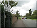
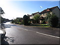
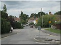
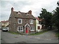
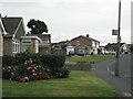
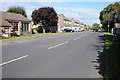
Thornbury is a civil parish and historic market town located in South Gloucestershire, approximately 12 miles north of Bristol. This community sits alongside the River Severn in the Severn Vale, covering an area of 16.9 square kilometres. With a population of 8,389 residents, the town maintains a density of 497 people per square kilometre. The area is defined by its established status, having received a market charter in 1252 and historically serving the region through its cattle market. You will find the town centre features a High Street recognised for its well-preserved character, having won a Britain in Bloom award and receiving recognition as one of Britain's best-preserved market towns. Living in Thornbury means engaging with a setting that blends historical significance with suburban convenience. Major landmarks include Thornbury Castle, a Tudor country house now operating as a luxury hotel, and the Grade I listed Church of Saint Mary the Virgin, which construction began in 1340. The area also hosts the Thornbury and District Museum, opened in 1988 to preserve local heritage. This location offers a specific type of suburban market town experience where daily life is centred around a historic core while remaining close to major road networks like the A38.
- Area Type
- Parish
- Area Size
- 16.9 km²
- Population
- 8389
- Population Density
- 497 people/km²
Demographics
The community profile of Thornbury reveals a distinct demographic shift towards an older population. The median age for residents is 70 years old, and the total age distribution is recorded as the most common range within the available data. This indicates a settlement where a significant portion of households likely consists of retirees or those nearing retirement. Home ownership is the dominant form of tenure, with 72% of all homes in Thornbury being owned outright or with a mortgage. Consequently, the rental sector comprises a smaller minority of the total housing stock. While specific data on predominant ethnic groups and Christian religious affiliation is not itemised in this dataset, the high rate of ownership suggests stability within the neighbourhood. Households in Thornbury reflect this tenure pattern, implying a community less driven by short-term letting than by long-term residency. For anyone considering homes in Thornbury, the prevailing picture is one of established ownership rather than transient living. This stability often translates into quiet residential streets and a neighbour base familiar with local changes over many years.
Household Size
Accommodation Type
Tenure
Ethnic Group
Religion
Household Composition
Age
Household Deprivation
NS-SEC
Explore more demographic insights in this area
Go to Demographics tabPlanning
Planning Constraints
- Flood RiskPremium
- Ramsar Wetland SitesPremium
- Area of Outstanding Natural BeautyPremium
- Protected Nature ReservePremium
- Protected WoodlandPremium