Area Overview for GL5 4AL
Photos of GL5 4AL
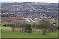
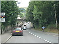
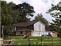
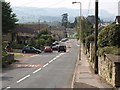
100 photos from this area
Area Information
Key information about the GL5 4AL including its size, population, and administrative classification.
- Area Type
- Postcode
- Area Size
- 1.8 hectares
- Population
- 1208
- Population Density
- 2039 people/km²
House Prices in GL5 4AL
48
Properties
£190,250
Average Sold Price
£62,000
Lowest Price
£420,000
Highest Price
Showing 48 properties
| Address | Type | Beds | Baths | Last Sale Price | Last Sale Date | |
|---|---|---|---|---|---|---|
| 82 Stratford Road, Stroud, GL5 4AL | Semi-detached | 3 | 1 | £290,000 | Mar 2023 | |
| 103 Stratford Road, Stroud, GL5 4AL | Detached | 4 | 1 | £390,000 | Jul 2022 | |
| 89 Stratford Road, Stroud, GL5 4AL | Retail | 4 | 2 | £420,000 | Mar 2022 | |
| 77 Stratford Road, Stroud, GL5 4AL | Semi-detached | 3 | 1 | £236,500 | Aug 2020 | |
| 93 Stratford Road, Stroud, GL5 4AL | Semi-detached | 3 | 2 | £245,000 | Nov 2017 | |
| 86 Stratford Road, Stroud, GL5 4AL | Semi-detached | 3 | - | £201,500 | Mar 2016 | |
| 56 Stratford Road, Stroud, GL5 4AL | house | 3 | 1 | £168,000 | Jul 2015 | |
| 91 Stratford Road, Stroud, GL5 4AL | Semi-detached | 3 | - | £194,000 | Jun 2015 | |
| 101 Stratford Road, Stroud, GL5 4AL | house | - | - | £198,000 | Jul 2012 | |
| 105 Stratford Road, Stroud, GL5 4AL | house | 3 | - | £177,500 | Apr 2012 |
Page 1 of 5
Energy Efficiency in GL5 4AL
Amenities
Schools
| Rank | School | Type | Entry gender | Ages |
|---|
Explore more schools in this area
Go to Schools tabDemographics
Household Size
Family (3-5 people)
most common
Accommodation Type
Houses
most common
Tenure
67
majority
Ethnic Group
White
most common
Religion
N/A
most common
Household Composition
N/A
most common
Age
47
median
Adults (30-64 years)
most common
Household Deprivation
N/A
with no deprivation
NS-SEC
36
in Lower managerial occupations
Explore more demographic insights in this area
Go to Demographics tabPlanning
Planning Constraints
- Flood RiskPremium
- Ramsar Wetland SitesPremium
- Area of Outstanding Natural BeautyPremium
- Protected Nature ReservePremium
- Protected WoodlandPremium