Area Overview for BS23 2LT
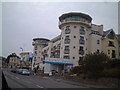
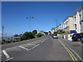
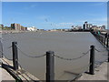
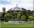
Photos of BS23 2LT
Area Information
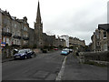
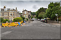
Living in BS23 2LT means being part of a tightly knit residential cluster in North Somerset, nestled within the historic seaside town of Weston-super-Mare. This postcode covers 20.8 hectares, housing 1,758 people in a densely populated area with a density of 1,564 people per square kilometre. The town’s character is defined by its Victorian heritage, with landmarks like the Grand Pier and seafront promenades shaping daily life. Residents here benefit from proximity to retail hubs, transport links, and the coastal charm of the Bristol Channel. The area’s compact size means amenities are within easy reach, while its history as a 19th-century resort town adds a layer of architectural and cultural richness. With a median age of 47, the community leans towards adults aged 30–64, creating a stable, mature demographic. While the area is small, its strategic location offers access to both local charm and broader regional connectivity.
- Area Type
- Postcode
- Area Size
- 20.8 hectares
- Population
- 1758
- Population Density
- 1564 people/km²
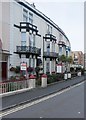
The property market in BS23 2LT is characterised by a 48% home ownership rate, meaning nearly half of residents rent their homes. The accommodation type is predominantly flats, which is typical for areas with high population density and limited space. This suggests a housing stock that prioritises efficiency over larger family homes. Given the area’s small size, the market is likely constrained, with limited scope for new developments. For buyers, this means competition for available properties, particularly flats in well-located buildings. The proximity to amenities like retail centres and transport hubs may offset the lack of space, making the area appealing to those prioritising convenience over expansive living. However, the rental market’s dominance indicates a transient element, which could affect property values and long-term stability.
House Prices in BS23 2LT
Showing 21 properties
| Address | Type | Beds | Baths | Last Sale Price | Last Sale Date | |
|---|---|---|---|---|---|---|
| 65 South Road, Weston Super Mare, BS23 2LT | Semi-detached | 2 | 2 | £265,000 | Mar 2020 | |
| 71 South Road, Weston Super Mare, BS23 2LT | Detached | - | - | £700,000 | Jul 2017 | |
| 67 South Road, Weston Super Mare, BS23 2LT | house | 2 | - | £190,000 | Jun 2007 | |
| 69 South Road, Weston Super Mare, BS23 2LT | house | - | - | £245,000 | Mar 2006 | |
| Flat 2, 61 South Road, Weston Super Mare, BS23 2LT | Flat | 3 | 2 | - | - | |
| 2, Silvercraig Mansions, South Road, Weston Super Mare, BS23 2LT | Flat | 2 | 2 | - | - | |
| 63A South Road, Weston Super Mare, BS23 2LT | Detached | 4 | 3 | - | - | |
| 1, Silvercraig Mansions, South Road, Weston Super Mare, BS23 2LT | Flat | - | - | - | - | |
| 3A, Silvercraig Mansions, South Road, Weston Super Mare, BS23 2LT | Flat | - | - | - | - | |
| 3, Silvercraig Mansions, South Road, Weston Super Mare, BS23 2LT | Flat | - | - | - | - |
Energy Efficiency in BS23 2LT
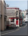
Life in BS23 2LT is shaped by its proximity to retail, transport, and coastal amenities. Within practical reach are five retail outlets, including Spar, Tesco Weston, and Morrisons Daily Weston Super, ensuring everyday needs are met locally. The area’s rail network, with stations at Weston, Weston Milton, and Worle, provides seamless access to regional hubs, while the Weston ferry offers a direct link to the Bristol Channel. Though the data does not specify parks or leisure spots, the town’s Victorian heritage—evident in landmarks like the Grand Pier—suggests recreational opportunities along the seafront. The compact nature of the area means residents can access these amenities without long commutes, fostering a convenient, connected lifestyle. The blend of retail, transport, and coastal proximity makes daily life practical and engaging for residents.
Amenities
Schools
| Rank | School | Type | Entry gender | Ages |
|---|
Explore more schools in this area
Go to Schools tabDemographics
BS23 2LT has a median age of 47, with the majority of residents falling into the 30–64 age range. This suggests a community of working-age adults and older professionals, contributing to a stable, established population. Home ownership is relatively low at 48%, indicating a significant proportion of residents rent their homes. The accommodation type is predominantly flats, reflecting a housing stock shaped by post-war development and the area’s compact footprint. The predominant ethnic group is White, aligning with broader trends in North Somerset. With a population density of 1,564 people per square kilometre, the area is densely populated, which can influence local services and social dynamics. This density, combined with the age profile, suggests a community focused on practical living rather than transient lifestyles.
Household Size
Accommodation Type
Tenure
Ethnic Group
Religion
Household Composition
Age
Household Deprivation
NS-SEC
Explore more demographic insights in this area
Go to Demographics tabPlanning
Planning Constraints
- Flood RiskPremium
- Ramsar Wetland SitesPremium
- Area of Outstanding Natural BeautyPremium
- Protected Nature ReservePremium
- Protected WoodlandPremium