Area Overview for RG2 8NP
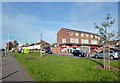
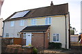
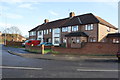
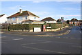
Photos of RG2 8NP
Area Information
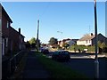
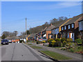
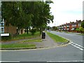
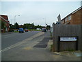
RG2 8NP is a small, densely populated residential cluster in England, covering just 5,930 square metres and home to 1,765 residents. Its compact size means the area is tightly knit, with a high population density of 297,634 people per square kilometre. This postcode is characterised by a mature community, with a median age of 47 and a majority of residents aged between 30 and 64. The area is predominantly owner-occupied, with 72% of homes owned by their occupants, and houses are the primary accommodation type. Daily life here is shaped by proximity to essential services, including multiple retail outlets and rail stations. The presence of Co-op Whitley, Lidl Whitley, and Tesco Reading within practical reach ensures residents have access to shopping and dining options. Nearby rail links, such as Earley and Reading stations, provide easy access to commuting routes. While the area lacks natural or protected landscapes, its focus on residential living and connectivity makes it a practical choice for those prioritising convenience and accessibility.
- Area Type
- Postcode
- Area Size
- 5930 m²
- Population
- 1765
- Population Density
- 6055 people/km²
The property market in RG2 8NP is dominated by owner-occupied homes, with 72% of properties owned by their residents. Houses are the primary accommodation type, suggesting a focus on family-sized or multi-bedroom properties. Given the area’s small size and high population density, the housing stock is likely limited, with few new developments. This makes the market competitive for buyers, particularly those seeking homes in a compact, well-serviced area. The proximity to retail outlets and rail stations may enhance property value, as these amenities are critical for daily living. However, the lack of protected or natural landscapes means the area’s appeal is rooted in practicality rather than scenic vistas. Buyers should consider the limited space and the potential for high demand, especially from those prioritising convenience over expansive outdoor areas.
House Prices in RG2 8NP
Showing 15 properties
| Address | Type | Beds | Baths | Last Sale Price | Last Sale Date | |
|---|---|---|---|---|---|---|
| 113 Foxhays Road, Reading, RG2 8NP | Semi-detached | 3 | 1 | £292,500 | Oct 2018 | |
| 111 Foxhays Road, Reading, RG2 8NP | Semi-detached | 3 | 1 | £303,000 | Feb 2017 | |
| 10 Foxhays Road, Reading, RG2 8NP | Semi-detached | 6 | 3 | £197,000 | Nov 2010 | |
| 115 Foxhays Road, Reading, RG2 8NP | house | - | - | £170,000 | Jul 2009 | |
| 18 Foxhays Road, Reading, RG2 8NP | house | - | - | £190,000 | Jan 2008 | |
| 26 Foxhays Road, Reading, RG2 8NP | house | - | - | £215,000 | Aug 2007 | |
| 119 Foxhays Road, Reading, RG2 8NP | Semi-detached | - | - | £175,000 | Oct 2004 | |
| 14 Foxhays Road, Reading, RG2 8NP | house | - | - | £93,000 | Feb 1998 | |
| 20 Foxhays Road, Reading, RG2 8NP | Semi-detached | - | - | - | - | |
| 12 Foxhays Road, Reading, RG2 8NP | Semi-detached | - | - | - | - |
Energy Efficiency in RG2 8NP
Living in RG2 8NP offers access to a range of amenities within close proximity. The area is served by five retail outlets, including Co-op Whitley, Lidl Whitley, and Tesco Reading, ensuring residents have convenient access to shopping and daily necessities. While the area itself is small, its rail network—comprising Earley, Reading, and Reading West stations—provides easy access to larger towns and cities, enhancing lifestyle options. The absence of major parks or leisure facilities within the postcode means residents may need to travel slightly further for recreational activities, but the compact nature of the area ensures that essential services are within walking or short driving distance. This balance of practicality and connectivity makes RG2 8NP suitable for those prioritising convenience over expansive amenities.
Amenities
Schools
| Rank | School | Type | Entry gender | Ages |
|---|
Explore more schools in this area
Go to Schools tabDemographics
The population of RG2 8NP is predominantly adults aged 30 to 64, with a median age of 47. This suggests a community of established professionals and families, many of whom are likely to be homeowners, as 72% of homes are owner-occupied. The accommodation type is primarily houses, reflecting a more traditional residential profile. The predominant ethnic group is White, which aligns with broader demographic trends in the region. The high population density—297,634 people per square kilometre—indicates a compact, possibly urbanised environment, though the area’s small size means it is not a sprawling suburb. This density may influence local infrastructure, such as the availability of retail and transport links. The absence of specific deprivation data means quality of life factors like access to services or green spaces must be inferred from the proximity to amenities like rail stations and supermarkets.
Household Size
Accommodation Type
Tenure
Ethnic Group
Religion
Household Composition
Age
Household Deprivation
NS-SEC
Explore more demographic insights in this area
Go to Demographics tabPlanning
Planning Constraints
- Flood RiskPremium
- Ramsar Wetland SitesPremium
- Area of Outstanding Natural BeautyPremium
- Protected Nature ReservePremium
- Protected WoodlandPremium