Area Overview for RG2 8NU
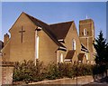
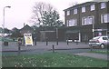
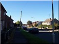
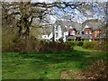
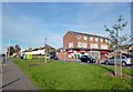
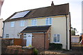
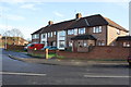
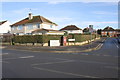
Photos of RG2 8NU
Area Information
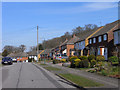
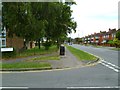
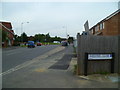
RG2 8NU is a compact residential postcode in England, covering just 6,874 square metres and home to 1,765 residents. Its high population density of 256,762 people per square kilometre reflects a tightly knit, small-scale community. This area is distinct for its focus on family-oriented living, with a median age of 47 and a majority of residents aged 30–64. Daily life here is shaped by proximity to essential services, including multiple retail outlets and rail links. The area’s small size means it is likely a quiet, residential enclave rather than a commercial hub, with homes predominantly owner-occupied. While the postcode lacks natural or protected landscapes, its practical amenities and connectivity make it appealing for those prioritising convenience over expansive green spaces. Living in RG2 8NU offers a balance of accessibility and community cohesion, with a population that leans towards middle-aged adults and a strong emphasis on private homeownership.
- Area Type
- Postcode
- Area Size
- 6874 m²
- Population
- 1765
- Population Density
- 6055 people/km²
The property market in RG2 8NU is characterised by a high rate of home ownership (72%), with houses making up the majority of accommodation types. This indicates a community where long-term residency is the norm, and the housing stock is likely to be established rather than newly developed. The small area size and limited data on property listings suggest a niche market, possibly with fewer options for buyers compared to larger towns or cities. As a residential cluster, the area may offer a mix of semi-detached or detached homes, catering to families or individuals seeking private, low-density living. For buyers, this could mean a focus on quality over quantity, with properties potentially holding value due to limited supply. However, the lack of specific data on property prices or development plans means the market’s dynamics remain somewhat opaque.
House Prices in RG2 8NU
Showing 18 properties
| Address | Type | Beds | Baths | Last Sale Price | Last Sale Date | |
|---|---|---|---|---|---|---|
| 523 Northumberland Avenue, Reading, RG2 8NU | house | - | - | £360,000 | May 2023 | |
| 535 Northumberland Avenue, Reading, RG2 8NU | house | - | - | £350,000 | Aug 2021 | |
| 529 Northumberland Avenue, Reading, RG2 8NU | house | - | - | £270,000 | Jan 2021 | |
| 539 Northumberland Avenue, Reading, RG2 8NU | Semi-detached | 3 | 1 | £307,000 | Apr 2019 | |
| 519 Northumberland Avenue, Reading, RG2 8NU | Terraced | 3 | 1 | £310,000 | Jan 2018 | |
| 543 Northumberland Avenue, Reading, RG2 8NU | house | - | - | £200,000 | Nov 2013 | |
| 533 Northumberland Avenue, Reading, RG2 8NU | Semi-detached | 3 | 1 | £195,000 | Aug 2013 | |
| 525 Northumberland Avenue, Reading, RG2 8NU | Terraced | - | - | £175,000 | Aug 2012 | |
| 513 Northumberland Avenue, Reading, RG2 8NU | Terraced | - | - | £165,000 | Mar 2012 | |
| 545 Northumberland Avenue, Reading, RG2 8NU | house | - | - | £174,000 | Jan 2010 |
Energy Efficiency in RG2 8NU
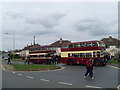
Living in RG2 8NU offers access to essential retail and transport hubs within practical reach. Nearby shops include Co-op Whitley, Lidl Whitley, and Aldi Unit 6 Gateway Retail Park, providing everyday convenience for groceries and household items. The area’s rail network is robust, with five stations—Earley, Reading, and Reading West—offering direct links to major cities and transport corridors. While the postcode itself is small, these amenities contribute to a lifestyle that prioritises ease of access over expansive leisure options. The retail presence suggests a community focused on practicality, with minimal need to travel far for basic needs. For those valuing convenience and connectivity, RG2 8NU delivers a straightforward, functional living experience.
Amenities
Schools
| Rank | School | Type | Entry gender | Ages |
|---|
Explore more schools in this area
Go to Schools tabDemographics
The community in RG2 8NU is predominantly composed of adults aged 30–64, with a median age of 47. This suggests a mature, stable population, likely with established careers and family commitments. Home ownership is high at 72%, indicating a preference for long-term residency over rental properties. The accommodation type is primarily houses, reflecting a residential area suited to families or individuals seeking private living spaces. The predominant ethnic group is White, with no specific data on diversity or deprivation levels provided. This demographic profile implies a community focused on stability and continuity, with fewer transient residents. The absence of detailed diversity statistics means the area’s cultural makeup remains less defined, though the high home ownership and age range suggest a relatively uniform social structure.
Household Size
Accommodation Type
Tenure
Ethnic Group
Religion
Household Composition
Age
Household Deprivation
NS-SEC
Explore more demographic insights in this area
Go to Demographics tabPlanning
Planning Constraints
- Flood RiskPremium
- Ramsar Wetland SitesPremium
- Area of Outstanding Natural BeautyPremium
- Protected Nature ReservePremium
- Protected WoodlandPremium