Area Overview for RG2 8LA
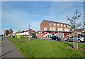
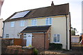
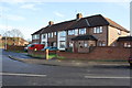
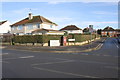
Photos of RG2 8LA
Area Information
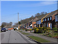
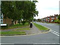
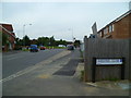
Living in RG2 8LA means inhabiting a compact, densely populated residential cluster in England, where 2,270 people reside across just 2.0 hectares. This small postcode area is characterised by its proximity to key infrastructure and amenities, making it a practical choice for those prioritising connectivity. The high population density of 110,878 people per square kilometre reflects a tightly knit community, though the area’s size means it is more of a micro-neighbourhood than a sprawling suburb. Residents benefit from being near major railway hubs such as Reading and Earley stations, which provide swift access to nearby towns and cities. The area’s compact nature ensures that daily errands and leisure activities are within walking or short driving distance, though its limited size means it is best viewed as part of a broader local network rather than a standalone destination. For those seeking a balance between urban convenience and residential tranquillity, RG2 8LA offers a distinct blend of proximity and practicality.
- Area Type
- Postcode
- Area Size
- 2.0 hectares
- Population
- 2270
- Population Density
- 2510 people/km²
The property market in RG2 8LA is defined by a 62% home ownership rate, suggesting that nearly two-thirds of properties are owner-occupied. The accommodation type is predominantly houses, which may indicate a lack of high-rise or apartment-style housing in the area. Given the postcode’s small size of 2.0 hectares, the housing stock is likely limited, making it a niche market for buyers seeking specific properties. The compact nature of the area means that the immediate surroundings, such as nearby towns or suburbs, may hold more extensive housing options. For buyers, this could mean that while RG2 8LA itself offers a focused selection of homes, the broader region provides additional choices. The presence of railway stations nearby may also influence property values, as transport links are often a key factor in residential demand.
House Prices in RG2 8LA
Showing 5 properties
| Address | Type | Beds | Baths | Last Sale Price | Last Sale Date | |
|---|---|---|---|---|---|---|
| 5 Nores Road, Shinfield, RG2 8LA | Detached | - | - | £284,000 | Nov 2004 | |
| 3 Nores Road, Shinfield, RG2 8LA | house | - | - | - | - | |
| 1 Nores Road, Shinfield, RG2 8LA | house | - | - | - | - | |
| 2 Nores Road, Shinfield, RG2 8LA | house | - | - | - | - | |
| 4 Nores Road, Shinfield, RG2 8LA | Semi-detached | - | - | - | - |
Energy Efficiency in RG2 8LA
The lifestyle in RG2 8LA is shaped by its proximity to retail and transport hubs. Nearby shops include Co-op Whitley, Lidl Whitley, and Aldi Unit 6 Gateway Retail Park, offering everyday essentials and grocery options within practical reach. These retail outlets cater to daily needs, reducing the necessity for long trips to larger shopping centres. The area’s rail links to Reading and Earley stations provide access to broader leisure and cultural opportunities, though the postcode itself lacks dedicated parks or recreational spaces. The compact nature of the area means that residents must look to adjacent neighbourhoods for green spaces or leisure facilities. Despite this, the convenience of nearby amenities and transport links ensures that daily life remains efficient and accessible for residents.
Amenities
Schools
The nearest school to RG2 8LA is the OneSchool Global UK Reading Primary Campus, an independent institution. This school type typically offers fee-paying education with a focus on international curricula, though specific Ofsted ratings or academic performance data are not included in the provided information. The presence of an independent school may appeal to families seeking alternative educational pathways, though it is important to note that the area does not list any state-funded schools. The limited number of schools in the vicinity suggests that families may need to look beyond the immediate postcode for additional educational options. For those prioritising a specific school environment, the OneSchool Global UK Reading Primary Campus provides a distinct choice, though its impact on the local community’s character is not detailed in the data.
| Rank | School | Type | Entry gender | Ages |
|---|
Explore more schools in this area
Go to Schools tabDemographics
The community in RG2 8LA is predominantly composed of adults aged 30–64, with a median age of 47. This suggests a mature, possibly family-oriented population, though specific data on household types or family structures is not provided. Home ownership rates stand at 62%, indicating a mix of owner-occupied properties and rental units. The accommodation type is primarily houses, which may reflect a preference for more spacious, traditional living arrangements. The predominant ethnic group is White, though no further breakdown of diversity is available. The high population density, combined with the age profile, implies a stable, long-term resident base rather than a transient or student-heavy population. While no deprivation data is included, the absence of significant planning constraints or environmental risks may contribute to a quality of life that is relatively secure and predictable for residents.
Household Size
Accommodation Type
Tenure
Ethnic Group
Religion
Household Composition
Age
Household Deprivation
NS-SEC
Explore more demographic insights in this area
Go to Demographics tabPlanning
Planning Constraints
- Flood RiskPremium
- Ramsar Wetland SitesPremium
- Area of Outstanding Natural BeautyPremium
- Protected Nature ReservePremium
- Protected WoodlandPremium