Area Overview for New Romney
Photos of New Romney

Area Information
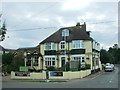
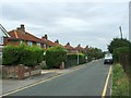
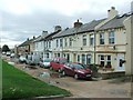
Living in New Romney offers a distinct experience within Kent, defined by its layout as a civil parish covering 9.1 km². This specific land size shapes the daily rhythm of the area, creating a setting that feels manageable yet substantial for those seeking a specific lifestyle. You will find yourself in a location where history and nature intersect, forming the backdrop for ordinary days and special events alike. The area does not spread across vast distances, which means local amenities and neighbours remain within a tight operational radius. This concentration of land and population creates a community where residents know one another, distinguishing New Romney from sprawling urban equivalents. When you consider moving to New Romney, you are entering an environment where the physical footprint of the parish dictates the pace of life. The 9.1 km² boundary encompasses a mix of residential zones and open spaces, requiring you to plan your life around the specific geography of this civil parish. There is no grey area here; you will know exactly how much land lies around you. This clarity allows you to make informed decisions about how you utilise the space available in homes in New Romney. Whether you prefer a quiet retreat or a community with local character, the defined boundaries of this parish provide the context you need.
- Area Type
- Parish
- Area Size
- 9.1 km²
- Population
- Not available
- Population Density
- Not available
Demographics
The community in New Romney presents a clear picture regarding age and stability. With a median age of 70, the population skews significantly towards older residents. This demographic profile suggests a town where retirement communities and established households dominate the social fabric. You will likely encounter a neighbourhood where life expectancy and lifestyle choices reflect this concentration of seniors. The breakdown of age groups is not evenly distributed, with the 'Total' age category serving as the only specified range in the records, reinforcing the dominance of this older cohort. Home ownership stands out as a defining feature of this neighbourhood. A staggering 77 per cent of residents own their homes outright. This high figure indicates that buying a property in New Romney is a long-term investment for the vast majority of you who choose this place. Rental markets appear minimal compared to owner-occupied stock. While specific details on household composition and predominant ethnic groups are not detailed in the current records, the overwhelming level of home ownership paints a portrait of stability. You are moving into an area where people have stakes in the community, likely remaining for decades rather than years.
Household Size
Accommodation Type
Tenure
Ethnic Group
Religion
Household Composition
Age
Household Deprivation
NS-SEC
Explore more demographic insights in this area
Go to Demographics tabPlanning
Planning Constraints
- Flood RiskPremium
- Ramsar Wetland SitesPremium
- Area of Outstanding Natural BeautyPremium
- Protected Nature ReservePremium
- Protected WoodlandPremium
- Crime RiskPremium