Area Overview for Littlestone-on-Sea
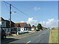
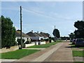
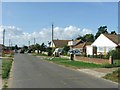
Photos of Littlestone-on-Sea


Area Information
Littlestone-on-Sea is a compact built-up area covering just 2.2 km², situated within the coastal town structure of the wider Romney Marsh region. This small footprint means daily life revolves around a concentrated community where neighbours know each other by name. The area functions as a distinct residential pocket, balancing the calm of a seaside location with the practicalities of a local town centre. Prospective buyers considering living in Littlestone-on-Sea should expect a residential environment defined by its intimacy and proximity to neighbouring settlements. The physical scale of the area ensures that most essential services and local routes remain within immediate reach without the need for extensive travel. Residents here appreciate the clear boundaries of their locality, which distinctively separates it from the broader Dover district while maintaining strong links to nearby towns. Housing in Littlestone-on-Sea caters primarily to established occupants, creating a residential rhythm free from the rapid turnover often found in larger urban centres. The area offers a straightforward living experience for those who prefer a settled community over a dynamic city centre scene. Its size limits development sprawl, preserving the visual character that defines the homes in Littlestone-on-Sea. For someone seeking a familiar, manageable environment, the area provides a stable setting with all the amenities required for modern domestic life.
- Area Type
- Built Up Area 250
- Area Size
- 2.2 km²
- Population
- Not available
- Population Density
- Not available
Daily life in Littlestone-on-Sea benefits from immediate access to five railway stations including Romney Sands Station, New Romney Station, and Romney Warren Halt. These stations provide reasonable rail links to wider Kent and Surrey networks, facilitating commuting to larger employment centres. Residents do not rely solely on the locality for transport, having five notable retail venues such as Spar, Co-op New, and Morrisons Daily Lydd-on within practical reach. These shops cover essential grocery needs and daily household requirements without the need for frequent car journeys. The presence of Lydd Airport and the Lydd London Ashford Airport adds a specific layer of convenience, particularly for residents requiring travel or online business logistics. While the area is compact, the ability to access airports and rail stations keeps the daily routine fluid. Shopping trips at the Co-op or Morrisons Daily Lydd-on are simple tasks integrated into the weekly schedule. The railway connections ensure that those wishing to visit Dover, London, or Dover Castle can do so with minimal disruption. This blend of local retail independence and external travel options creates a well-rounded lifestyle. Home buyers value the ability to manage weekly food shopping locally while retaining easy access to broader travel networks via the nearby airport stations.
Amenities
Schools
Families considering schools near Littlestone-on-Sea have one primary option immediately listed in the local data: Greatstone Primary School. This institution is a primary school holding a Ofsted rating of good, which places it firmly in the upper tier of government educational standards. Having a school with a good rating provides reassurance to parents regarding the quality of instruction and overall environment available to young children. Greatstone Primary School serves as the main educational anchor for the area, catering to the primary education needs of residents within the locality. The school mix in Littlestone-on-Sea currently reflects the specific data of one primary education venue, though secondary options would likely be accessed through neighbouring towns such as Romney or Lydd, given the small size of the area. The presence of a single primary school with a positive Ofsted judgement simplifies the decision-making process for families settling in Littlestone-on-Sea. Parents can rely on the verified quality of Greatstone Primary School as a sufficient resource for early years education. While the data does not list secondary schools, the provision of a good-rated primary institution ensures that foundational education is handled competently locally. This setup is ideal for families prioritising dependable primary schooling before potential transfers to larger secondary hubs in the surrounding district.
| Rank | School | Type | Entry gender | Ages |
|---|
Explore more schools in this area
Go to Schools tabDemographics
The community profile of Littlestone-on-Sea reflects an area with an ageing population structure. According to the demographic data, the median age stands at 70, indicating a resident base significantly older than the UK national average. This age distribution suggests Littlestone-on-Sea serves as a retirement destination or a location for mature families seeking a quieter retirement lifestyle. Home ownership rates remain exceptionally high at 77%, confirming that the vast majority of residents are owners rather than tenants. This high ownership level typically correlates with stability and long-term commitments to the locality. The household composition and accommodation type data for the area point towards established living arrangements typical of a mature village community. While specific breakdowns of family units or single-person households are not detailed in the public statistics provided, the overall demographic picture paints one of enduring residency. The high percentage of owner-occupied homes reinforces the idea that Littlestone-on-Sea is a place people intend to stay for the remainder of their lives. There is a notable absence of rental market volatility, which often benefits residents looking for permanence. The settlement maintains a traditional character where the population has grown organically over decades rather than through transient student housing or short-term corporate rentals.
Household Size
Accommodation Type
Tenure
Ethnic Group
Religion
Household Composition
Age
Household Deprivation
NS-SEC
Explore more demographic insights in this area
Go to Demographics tabPlanning
Planning Constraints
- Crime RiskPremium