Area Overview for Elmbridge District (B)
Photos of Elmbridge District (B)


Area Information
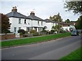
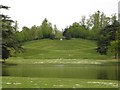
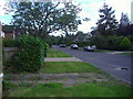
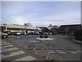
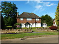
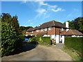
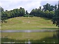
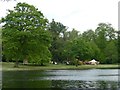
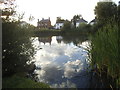
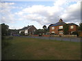
Elmbridge District (B) stands as a local authority district within Surrey, covering an area size of 96.4 km². This borough unitary lies along the River Thames and River Mole, positioning it southwest of London. The district encompasses a collection of towns and villages, including Esher, Weybridge, Walton-on-Thames, Molesey, Cobham, and Claygate. Historically, this land was defined as the Saxon hundred of Amelebrige, recorded in the Domesday Book of 1086. Living in Elmbridge District (B) means inhabiting a region that has evolved from a rural Saxon setting into a modern housing corridor. The area developed significantly after the arrival of the London and Southampton Railway in 1838, which spurred rapid population growth. Today, the district reflects this history with early 20th-century estates exhibiting Surrey 'urban vernacular' architecture. You will find homes transitioning from purely rural settings to established commuter suburbs. The landscape retains notable features such as Painshill Park landscape at Cobham, created from 1736. This park features a ruined abbey, a Gothic pavilion, and a grotto alongside remnants of Oatlands Palace in Weybridge. Former mills along the River Mole also remain part of the local heritage. The mix of suburban towns and villages creates a daily life for residents who often commute to London. You are living in a district where historical significance meets practical suburban needs.
- Area Type
- District/Borough
- Area Size
- 96.4 km²
- Population
- Not available
- Population Density
- Not available
Demographics
The community within Elmbridge District (B) displays a distinct age profile with a median age of 70. This high median age suggests a significant population of older adults residing across the borough. The most common age range is listed as Age: Total, indicating the dataset aggregates across all decades without further breakdown. A key statistic for understanding this community is the home ownership level, which stands at 72%. This figure places Elmbridge District (B) firmly as an owner-occupied area rather than a rental market. Consequently, households in this district are likely to be established and stable, given that nearly three-quarters of residents own their property. The available data does not specify predominant ethnic groups, religious affiliations, or detailed household composition beyond these aggregate figures. When you consider buying homes in Elmbridge District (B), the high ownership rate signals a neighbourhood where people are likely put down roots. The demographic structure points towards a quieter environment suited to retirement or later-life living rather than a young family hub. You should expect a demographic landscape defined by long-term residents who have likely acquired their properties over many years. The lack of specific data on diversity means the community picture relies heavily on the retirement-oriented metrics provided.
Household Size
Accommodation Type
Tenure
Ethnic Group
Religion
Household Composition
Age
Household Deprivation
NS-SEC
Explore more demographic insights in this area
Go to Demographics tabPlanning
Planning Constraints
- Flood RiskPremium
- Ramsar Wetland SitesPremium
- Area of Outstanding Natural BeautyPremium
- Protected Nature ReservePremium
- Protected WoodlandPremium
- Crime RiskPremium