Area Overview for CT1 1AE
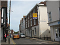
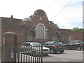
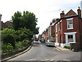
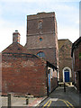
Photos of CT1 1AE
Area Information
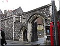
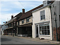
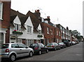
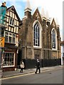
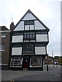
CT1 1AE is a compact residential postcode in Canterbury, Kent, with a population of 1,853 spread across 897 square metres. This makes it one of the most densely populated areas in England, with over two million people per square kilometre. The area sits within Northgate Ward, historically defined by the medieval North Gate of Canterbury’s city walls. Today, it is a mix of modern flats and historic sites, including the deconsecrated St Mary Northgate Church, now owned by King’s School. Daily life here is shaped by proximity to Canterbury’s city centre, with easy access to retail, transport, and cultural landmarks. The area’s small size means residents share a tight-knit community, though the high density can create a sense of congestion. Despite its compact nature, CT1 1AE benefits from Canterbury’s broader infrastructure, including rail links and primary schools with good Ofsted ratings. For buyers, it is a niche market with limited housing stock, requiring careful consideration of location and lifestyle needs.
- Area Type
- Postcode
- Area Size
- 897 m²
- Population
- Not available
- Population Density
- Not available
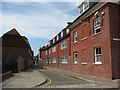
CT1 1AE is a small, densely populated area where home ownership is limited to 29%, making it primarily a rental market. The accommodation type is predominantly flats, reflecting the area’s constraints in space and its historical development as a compact residential cluster. With only 897 square metres of land for 1,853 residents, the housing stock is tightly packed, and buyers must consider the scarcity of properties. The area’s proximity to Canterbury’s city centre may appeal to those seeking urban convenience, but the lack of larger homes or detached properties means it is not ideal for buyers seeking spacious living. Those considering purchase should also note the high population density, which may influence property values and availability. The immediate surroundings offer limited alternative housing options, making CT1 1AE a niche market for those prioritising location over size.
House Prices in CT1 1AE
No properties found in this postcode.
Energy Efficiency in CT1 1AE
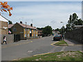
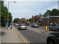
Daily life in CT1 1AE is shaped by its proximity to Canterbury’s city centre, offering access to retail, dining, and cultural attractions. The area’s nearby amenities include Sainsburys Canterbury and M&S Canterbury, providing essential shopping options. While the area itself lacks large parks or leisure facilities, its location within Canterbury grants residents access to the city’s broader offerings, such as historic sites and green spaces. The Northgate Ward Community Centre, established in 1997, adds to the local character, though it is not explicitly listed in the data. The compact size of CT1 1AE means residents must venture slightly beyond the postcode for major amenities, but the density ensures that essential services are within walking or short driving distance. This balance of convenience and urban proximity defines the lifestyle for those living in the area.
Amenities
Schools
Residents of CT1 1AE have access to several primary schools, including Kingsmead Primary School, Diocesan and Payne Smith Church of England Primary School, St Thomas’ Catholic Primary School, Canterbury, and St Johns Church of England Primary School. Two of these—St Thomas’ and St Johns—have been rated ‘good’ by Ofsted, offering families a choice between state and church-affiliated education. The presence of multiple primary schools within close proximity ensures that children have access to varied educational environments, though the area lacks secondary schools. For families, this means reliance on nearby Canterbury schools for secondary education. The mix of school types may appeal to parents seeking either a secular or faith-based curriculum, but the limited number of schools within CT1 1AE itself necessitates commuting for higher education.
| Rank | School | Type | Entry gender | Ages |
|---|---|---|---|---|
| 1 | Kingsmead Primary School | primary | N/A | N/A |
| 2 | Diocesan and Payne Smith Church of England Primary School | primary | N/A | N/A |
| 3 | St Thomas' Catholic Primary School, Canterbury | primary | N/A | N/A |
| 4 | St Johns Church of England Primary School | primary | N/A | N/A |
Explore more schools in this area
Go to Schools tabDemographics
The population of CT1 1AE has a median age of 22, though the most common age group is adults aged 30–64, suggesting a mix of young professionals and established families. Home ownership is low at 29%, indicating a rental-dominated market. The area is primarily composed of flats, reflecting its high density and limited space for larger properties. The predominant ethnic group is White, with no data provided on other demographics. The high population density—over two million people per square kilometre—may impact living conditions, though the area’s compact size fosters proximity to amenities. For families, the presence of multiple primary schools with good Ofsted ratings offers educational options. However, the low home ownership rate and high density mean housing choices are limited, and renters may face competition for available units.
Household Size
Accommodation Type
Tenure
Ethnic Group
Religion
Household Composition
Age
Household Deprivation
NS-SEC
Explore more demographic insights in this area
Go to Demographics tabPlanning
Planning Constraints
- Flood RiskPremium
- Ramsar Wetland SitesPremium
- Area of Outstanding Natural BeautyPremium
- Protected Nature ReservePremium
- Protected WoodlandPremium
- Crime RiskPremium