Area Overview for CT1 1BB
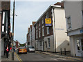
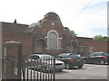
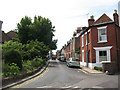
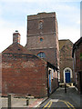
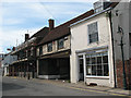
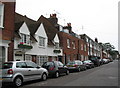
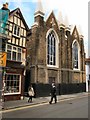
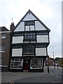
Photos of CT1 1BB
Area Information
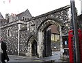
CT1 1BB is a compact residential postcode in Canterbury, Kent, encompassing 3,509 square metres and home to 1,853 people. Its high population density of 528,077 people per square kilometre reflects a tightly knit community, though the area remains small enough to feel intimate. Nestled in Northgate Ward, historically linked to Canterbury’s medieval walls and the former North Gate, the postcode sits near landmarks like St Mary Northgate Church and the Northgate Ward Community Centre. Daily life here is shaped by proximity to Canterbury’s historic core, with easy access to the city’s cultural and commercial hubs. The area’s mix of modern flats and historical context creates a unique blend of contemporary living and heritage. While the population is young, with a median age of 22, the majority of residents are adults aged 30–64, suggesting a balance of young professionals and established families. The compact size means amenities and services are within walking distance, though the area’s small footprint limits expansion. For buyers, this postcode offers a slice of Canterbury’s character, albeit in a densely populated setting.
- Area Type
- Postcode
- Area Size
- 3509 m²
- Population
- Not available
- Population Density
- Not available
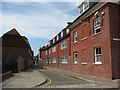
The property market in CT1 1BB is characterised by a low home ownership rate of 29%, suggesting that the area is primarily a rental market rather than one dominated by owner-occupied homes. The predominant accommodation type is flats, which is typical for high-density urban areas. Given the postcode’s small size of 3,509 square metres and high population density, the housing stock is likely limited, with little scope for new development. This makes the area attractive to renters seeking proximity to Canterbury’s amenities but may present challenges for buyers seeking long-term investment. The concentration of flats could also mean limited options for larger families or those preferring detached housing. For those considering purchase, the small area and high density suggest that properties here are likely to be in demand, though competition for available units may be fierce.
House Prices in CT1 1BB
No properties found in this postcode.
Energy Efficiency in CT1 1BB
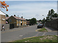
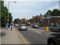
Living in CT1 1BB offers access to a range of amenities within practical reach. Retail options include Sainsburys Canterbury and M&S Canterbury, providing everyday shopping needs. The area’s rail connectivity, with stations like Canterbury West and Sturry, enhances accessibility to the city’s broader commercial and cultural hubs. While specific parks or leisure facilities are not listed, the proximity to Canterbury’s historic sites—such as the Northgate Ward Community Centre and the remnants of medieval walls—adds a layer of local character. The compact size of the postcode means residents can walk to shops, schools, and transport links, fostering a convenient, compact lifestyle. However, the absence of named parks or recreational spaces suggests that outdoor activities may require travel beyond the immediate area. The blend of retail, transport, and historical context creates a functional yet historically rich environment for daily living.
Amenities
Schools
Residents of CT1 1BB have access to several primary schools, including Kingsmead Primary School, Diocesan and Payne Smith Church of England Primary School, St Thomas’ Catholic Primary School, Canterbury, and St Johns Church of England Primary School. Of these, St Thomas’ and St Johns have Ofsted ratings of ‘good’, indicating strong educational provision. The presence of multiple primary schools, particularly those with positive evaluations, is a significant advantage for families, offering choices in schooling and potentially reducing travel times. The variety of school types—state and church-affiliated—reflects the area’s diverse community needs. For parents, the proximity of these schools to homes in CT1 1BB means daily commutes are minimal, supporting a family-friendly environment. However, the absence of secondary schools in the immediate vicinity may require additional travel for older students, though Canterbury’s city centre is within reach.
| Rank | School | Type | Entry gender | Ages |
|---|---|---|---|---|
| 1 | Kingsmead Primary School | primary | N/A | N/A |
| 2 | Diocesan and Payne Smith Church of England Primary School | primary | N/A | N/A |
| 3 | St Thomas' Catholic Primary School, Canterbury | primary | N/A | N/A |
| 4 | St Johns Church of England Primary School | primary | N/A | N/A |
Explore more schools in this area
Go to Schools tabDemographics
The community in CT1 1BB is predominantly young, with a median age of 22, though the most common age range is 30–64 years. This suggests a mix of young professionals and middle-aged adults, possibly reflecting a transient population or a shift in demographics. Home ownership is low at 29%, indicating that the majority of residents are renters, which may influence the local property market’s dynamics. The primary accommodation type is flats, aligning with the area’s high density. The predominant ethnic group is White, though specific data on diversity is not provided. The low home ownership rate and high proportion of adults in the 30–64 range could imply a rental market skewed toward professionals or families seeking short-term housing. The area’s compact size and historical significance may attract those prioritising location over property ownership, though the limited housing stock could pose challenges for long-term residents.
Household Size
Accommodation Type
Tenure
Ethnic Group
Religion
Household Composition
Age
Household Deprivation
NS-SEC
Explore more demographic insights in this area
Go to Demographics tabPlanning
Planning Constraints
- Flood RiskPremium
- Ramsar Wetland SitesPremium
- Area of Outstanding Natural BeautyPremium
- Protected Nature ReservePremium
- Protected WoodlandPremium
- Crime RiskPremium