Area Overview for CT1 2EX
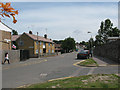
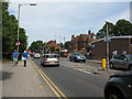
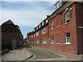
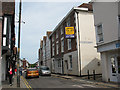
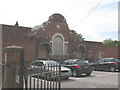
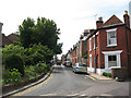
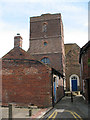
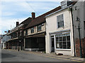
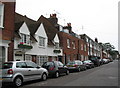
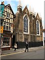
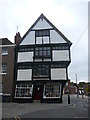
Photos of CT1 2EX
Area Information
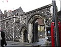
Living in CT1 2EX means being part of a tightly knit residential cluster in Canterbury, a historic city in Kent. The postcode covers 664 square metres and is home to 1,853 people, resulting in a remarkably high population density of 2,789,018 people per square kilometre. This compact area sits near the Westgate, Canterbury’s iconic medieval city gate, which remains a Grade I listed monument. The area’s small size means amenities, schools, and transport links are within easy reach, though its density reflects a focus on residential living rather than sprawling development. The proximity to the Westgate, with its historic architecture and museum, adds a distinct character to daily life. Residents benefit from a mix of modern and historic surroundings, with the area’s compact nature fostering a sense of community. However, the high density also underscores the need for efficient local services and infrastructure. For those seeking a blend of history and convenience, CT1 2EX offers a unique position within Canterbury’s urban fabric.
- Area Type
- Postcode
- Area Size
- 664 m²
- Population
- Not available
- Population Density
- Not available
The property market in CT1 2EX is characterised by a low home ownership rate of 29%, suggesting that the area is predominantly a rental market. The accommodation type is overwhelmingly flats, which aligns with the compact nature of the postcode and its high population density. This configuration implies that the housing stock is designed for efficiency rather than spaciousness, catering to individuals or small households. For buyers, the small area size and focus on flats may limit options for larger properties or family homes. The rental market dominance could also mean competition for available units, particularly in a city like Canterbury with limited housing stock. Prospective buyers should consider the area’s suitability for those prioritising convenience and proximity to amenities over expansive living space, while being mindful of the challenges posed by a high-density environment.
House Prices in CT1 2EX
No properties found in this postcode.
Energy Efficiency in CT1 2EX
The lifestyle in CT1 2EX is shaped by its proximity to retail and transport hubs. Within practical reach are five retail venues, including Sainsburys Canterbury and M&S Canterbury, offering everyday shopping convenience. The area’s rail network, with stations such as Canterbury West and Sturry, connects residents to broader destinations, enhancing mobility. While the postcode itself is small, the surrounding infrastructure ensures that essential amenities are accessible without significant travel. The compact nature of the area fosters a community-oriented environment, where local shops and transport links contribute to a practical, efficient lifestyle. However, the absence of parks or leisure facilities within the immediate area may require residents to venture slightly further for recreational activities.
Amenities
Schools
Residents of CT1 2EX have access to several primary schools, including Kingsmead Primary School, Diocesan and Payne Smith Church of England Primary School, St Thomas’ Catholic Primary School, and St Johns Church of England Primary School. Three of these schools—St Thomas’ and St Johns—have been rated ‘good’ by Ofsted, indicating a strong standard of education. The presence of both Church of England and Catholic schools offers families a range of educational options aligned with different faiths or preferences. The concentration of primary schools within the area suggests that parents have multiple choices for their children’s early education, though secondary schooling may require commuting to nearby districts. The quality of these schools, particularly the ‘good’ ratings, could be a significant draw for families prioritising education when considering the area.
| Rank | School | Type | Entry gender | Ages |
|---|---|---|---|---|
| 1 | Kingsmead Primary School | primary | N/A | N/A |
| 2 | Diocesan and Payne Smith Church of England Primary School | primary | N/A | N/A |
| 3 | St Thomas' Catholic Primary School, Canterbury | primary | N/A | N/A |
| 4 | St Johns Church of England Primary School | primary | N/A | N/A |
Explore more schools in this area
Go to Schools tabDemographics
The community in CT1 2EX is predominantly composed of adults aged 30–64, with a median age of 22. This suggests a mix of younger residents, possibly students or early-career professionals, alongside a larger middle-aged population. Home ownership is relatively low at 29%, indicating that the area is more rental-focused than owner-occupied. The accommodation type is primarily flats, reflecting a high-rise or converted housing stock typical of urban areas. The predominant ethnic group is White, with no specific data provided on other demographics. The low home ownership rate may impact long-term investment potential, while the concentration of adults in the 30–64 age range could suggest a stable, working-age population. However, the high population density raises questions about housing pressures and the need for community amenities to support this demographic.
Household Size
Accommodation Type
Tenure
Ethnic Group
Religion
Household Composition
Age
Household Deprivation
NS-SEC
Explore more demographic insights in this area
Go to Demographics tabPlanning
Planning Constraints
- Flood RiskPremium
- Ramsar Wetland SitesPremium
- Area of Outstanding Natural BeautyPremium
- Protected Nature ReservePremium
- Protected WoodlandPremium
- Crime RiskPremium