Area Overview for CT1 1BG
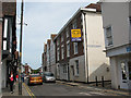
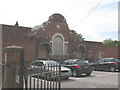
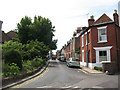
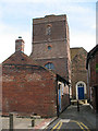
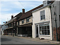
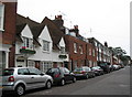
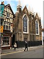
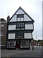
Photos of CT1 1BG
Area Information
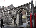
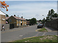
CT1 1BG is a compact postcode area in Canterbury, Kent, encompassing a small residential cluster with a population of 1853 people. Despite its modest size of 6168 square metres, it is densely populated, with 300,410 people per square kilometre. The area sits within Northgate Ward, historically linked to Canterbury’s medieval walls and the former North Gate. Today, it is a tight-knit community with a young median age of 22, though the most common age range is adults aged 30–64. The area’s proximity to Canterbury’s city centre and its historical landmarks, such as the site of the demolished North Gate, offer a blend of modern living and heritage. Residents benefit from nearby amenities, including retail hubs like Sainsburys and railway stations connecting to Canterbury East, West, and Sturry. The area’s compact nature means daily life is centred around local services and transport links, making it practical for those prioritising convenience over sprawling suburban layouts.
- Area Type
- Postcode
- Area Size
- 6168 m²
- Population
- Not available
- Population Density
- Not available
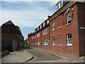
The property market in CT1 1BG is characterised by a high proportion of rental properties, with only 29% of homes owned by residents. Flats dominate the accommodation type, reflecting the area’s small size and high density. This suggests a focus on purpose-built housing or converted buildings suited to urban living. The compact nature of the postcode means the housing stock is limited, with little scope for expansion. For buyers, this could mean competition for a small number of available properties, particularly owner-occupied flats. The area’s proximity to Canterbury’s amenities may attract investors seeking rental income, but the lack of larger homes or detached properties limits options for families or those prioritising space.
House Prices in CT1 1BG
No properties found in this postcode.
Energy Efficiency in CT1 1BG
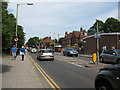
Living in CT1 1BG offers access to essential amenities within practical reach. Retail options include Sainsburys Canterbury and M&S Canterbury, providing grocery and clothing needs. The area’s railway stations—Canterbury West, Canterbury East, and Sturry—connect residents to broader transport networks, enhancing mobility. While the data does not specify parks or leisure facilities, the proximity to Canterbury’s city centre implies access to cultural and recreational spaces. The compact layout means daily life is centred around local services, with a focus on convenience over expansive green spaces. The presence of multiple schools and retail outlets suggests a community-oriented lifestyle, though residents may need to travel further for specialist amenities.
Amenities
Schools
Residents of CT1 1BG have access to several primary schools, including Kingsmead Primary School and Diocesan and Payne Smith Church of England Primary School. Two schools—St Thomas’ Catholic Primary School, Canterbury, and St Johns Church of England Primary School—hold Ofsted ratings of ‘good’. This mix of state and faith-based schools offers families a range of educational options, though none of the listed schools are secondary institutions. The presence of multiple primary schools within proximity suggests the area is well-suited for young families, with a focus on early education. However, parents seeking secondary schooling would need to look beyond the immediate vicinity.
| Rank | School | Type | Entry gender | Ages |
|---|---|---|---|---|
| 1 | Kingsmead Primary School | primary | N/A | N/A |
| 2 | Diocesan and Payne Smith Church of England Primary School | primary | N/A | N/A |
| 3 | St Thomas' Catholic Primary School, Canterbury | primary | N/A | N/A |
| 4 | St Johns Church of England Primary School | primary | N/A | N/A |
Explore more schools in this area
Go to Schools tabDemographics
The community in CT1 1BG is predominantly composed of adults aged 30–64, with a median age of 22, suggesting a mix of younger residents and those in their prime working years. Only 29% of homes are owner-occupied, indicating a rental-heavy market, while flats are the primary accommodation type. The predominant ethnic group is White, reflecting Canterbury’s demographic profile. The high population density—300,410 people per square kilometre—suggests a compact, possibly multi-generational living environment. While the data does not specify deprivation levels, the low home ownership rate and dense housing could imply limited long-term investment in property. This may affect the area’s appeal to families seeking stable, owner-occupied homes, though it also suggests a dynamic, transient population.
Household Size
Accommodation Type
Tenure
Ethnic Group
Religion
Household Composition
Age
Household Deprivation
NS-SEC
Explore more demographic insights in this area
Go to Demographics tabPlanning
Planning Constraints
- Flood RiskPremium
- Ramsar Wetland SitesPremium
- Area of Outstanding Natural BeautyPremium
- Protected Nature ReservePremium
- Protected WoodlandPremium
- Crime RiskPremium