Area Overview for BN6 8XE
Photos of BN6 8XE
Area Information
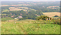
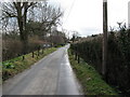
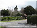
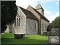
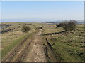
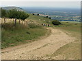
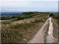
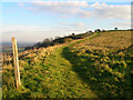
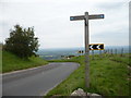
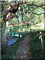
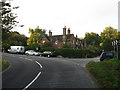
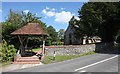
Living in BN6 8XE, a small residential cluster within Ditchling, East Sussex, offers a blend of rural tranquillity and historic charm. The area spans 46.1 hectares, home to 2,554 residents, with a population density of 107 people per square kilometre. Situated within the South Downs National Park, it is defined by its hilltop location, crossed by the Roman Greensand Way, and steeped in Anglo-Saxon and medieval history. The village retains its authentic character, with over 40 listed buildings and a legacy of the Arts and Crafts movement. Daily life here is shaped by its proximity to nature, with easy access to open landscapes and a strong sense of community. The area’s compact size means amenities and services are within practical reach, while its historic roots, including a 13th-century church and a 16th-century manor house, contribute to a distinct, timeless atmosphere. For those seeking a peaceful, low-density environment with cultural depth, BN6 8XE provides a unique opportunity to live in a village that balances heritage with modern convenience.
- Area Type
- Postcode
- Area Size
- 46.1 hectares
- Population
- 2554
- Population Density
- 107 people/km²
The property market in BN6 8XE is characterised by high home ownership (83%) and a predominance of houses, reflecting a low-density, residential area. This suggests a market primarily driven by owner-occupiers rather than renters, which may indicate limited availability of rental properties. The compact size of the postcode area—just 46.1 hectares—means the housing stock is finite, potentially leading to competition among buyers. The focus on houses rather than flats or apartments aligns with the village’s rural, suburban setting. For buyers, this implies a niche market with opportunities for long-term investment, though the limited scale of the area means properties may be scarce. The presence of historic and listed buildings also adds unique value, appealing to those seeking characterful homes with heritage features.
House Prices in BN6 8XE
Showing 24 properties
| Address | Type | Beds | Baths | Last Sale Price | Last Sale Date | |
|---|---|---|---|---|---|---|
| Wick Place, Underhill Lane, Westmeston, BN6 8XE | house | 6 | 4 | £3,250,000 | Jun 2025 | |
| Down House, Underhill Lane, Westmeston, BN6 8XE | house | - | - | £1,775,000 | Mar 2021 | |
| Old Barn Homestead, Underhill Lane, Westmeston, BN6 8XE | house | - | - | £1,800,000 | Sep 2020 | |
| Tara, Underhill Lane, Westmeston, BN6 8XE | Bungalow | 4 | 3 | £800,000 | Sep 2018 | |
| Little Straddles, Underhill Lane, Westmeston, BN6 8XE | Detached | 4 | 2 | £765,000 | Mar 2018 | |
| Meadow Cottage, Underhill Lane, Westmeston, BN6 8XE | Detached | 4 | 3 | £859,400 | Jul 2014 | |
| Holly Trees, Underhill Lane, Westmeston, BN6 8XE | house | 6 | - | £2,725,000 | Sep 2011 | |
| Tintern, Underhill Lane, Westmeston, BN6 8XE | Detached | - | - | £220,000 | Apr 2008 | |
| Coombe Wood, Underhill Lane, Westmeston, BN6 8XE | Detached | 6 | 3 | £730,000 | Jul 2004 | |
| Wick Farmhouse, Underhill Lane, Westmeston, BN6 8XE | Detached | - | - | £775,000 | Feb 2002 |
Energy Efficiency in BN6 8XE
The lifestyle in BN6 8XE is shaped by its proximity to retail, dining, and cultural amenities. Nearby shops include Morrisons Daily Hassocks 44, Sainsburys Hassocks, and M&S Pyecombe BP, offering everyday essentials and convenience. The village’s historic character is complemented by its vibrant community, with landmarks such as St Margaret’s Church, the Ditchling Museum of Art + Craft, and the biennial Ditchling Fair adding cultural depth. The presence of rail stations within practical reach enhances access to urban amenities without compromising the village’s rural charm. The area’s low density and historic buildings create a relaxed, community-focused environment, where daily life is influenced by tradition, nature, and local events. This blend of practicality and heritage makes BN6 8XE appealing to those seeking a balanced, low-stress lifestyle.
Amenities
Schools
BN6 8XE is served by two primary schools: Ditchling (St Margaret’s) Church of England Primary School and Ditchling St Margaret’s Church of England Primary School. Both are primary institutions, though specific Ofsted ratings are not provided in the data. The presence of two primary schools within the area offers families options for early education, though the lack of secondary schools means students may need to travel to nearby towns for higher education. This reflects the village’s small size and focus on primary-level schooling. The schools’ names suggest a connection to the local church, which may influence the educational ethos. For families prioritising primary education, the dual provision provides flexibility, but the absence of secondary options should be considered in long-term planning.
| Rank | School | Type | Entry gender | Ages |
|---|
Explore more schools in this area
Go to Schools tabDemographics
BN6 8XE has a median age of 47, with the elderly (65+ years) forming the most common age group. This suggests a community with a strong presence of long-term residents and families with older dependents. Home ownership is high at 83%, indicating a stable, settled population. The area is predominantly composed of houses, reflecting a low-density, suburban character. The predominant ethnic group is White, with no specific data on other demographics provided. The low population density of 107 people per square kilometre further reinforces the village’s rural, quiet nature. This profile implies a community focused on comfort, tradition, and proximity to nature, with fewer transient residents. The absence of detailed diversity data means the area’s social fabric is likely homogenous, which may appeal to those seeking a cohesive, familiar environment.
Household Size
Accommodation Type
Tenure
Ethnic Group
Religion
Household Composition
Age
Household Deprivation
NS-SEC
Explore more demographic insights in this area
Go to Demographics tabPlanning
Planning Constraints
- Flood RiskPremium
- Ramsar Wetland SitesPremium
- Area of Outstanding Natural BeautyPremium
- Protected Nature ReservePremium
- Protected WoodlandPremium