Area Overview for CH60 0DW
Photos of CH60 0DW
Area Information
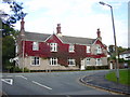
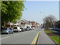
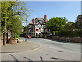
Living in CH60 0DW means residing within a specific residential cluster on the Wirral Peninsula that blends village charm with suburban convenience. This postcode covers an area of 1,467 square metres surrounded by the wider built-up area of Heswall, which recorded a population of 29,075 in the 2021 census. Your immediate neighbourhood contains approximately 1,526 residents, creating a close-knit environment despite its small physical footprint. The area is defined by its location near the historic boundary between Cheshire and Merseyside, offering a setting that feels distinct from the busier town centres nearby. Daily life here centres on a community where the past and present coexist, with the built environment reflecting centuries of history from the Domesday Book era to the late 19th-century expansion driven by Liverpool merchants. You will find yourself in a setting that balances quiet residential streets with proximity to commercial activity. The town of Heswall itself comprises an upper village full of shops and a lower village designated as a conservation area, both influencing the character of homes in CH60 0DW. This location provides a practical base for those seeking homes in this district while maintaining easy access to the wider transport and amenity networks of the Wirral Peninsula.
- Area Type
- Postcode
- Area Size
- 1467 m²
- Population
- 1526
- Population Density
- 1921 people/km²
The property market in CH60 0DW is distinctly characterised by a shortage of rental stock in favour of owner-occupied residences. With 75% of residents holding a mortgage-free home, this postcode operates as a primarily owner-occupied zone rather than a rental hub. This high level of homeownership means you are likely to encounter sale listings for established properties rather than tenancies. The accommodation type is strictly houses, meaning there are no flats or apartments to consider when searching for homes in this specific cluster. The built environment supports this pattern, as the area attracts families and professionals who stay for the long term rather than transient renters. When viewing properties near CH60 0DW, you will find a mix of historic dwellings, some designed by architect James Francis Doyle, alongside more modern builds that respect the local conservation constraints. The fact that the area sits within a conservation designation set in 1979 means architectural changes are heavily regulated, protecting the original character of the settlement. This regulatory environment tends to hold property values steady and prevents the rapid turnover common in speculative new-build estates. Buyers looking at this small residential cluster should expect a market driven by local sentiment and established value rather than investment speculation. The 300 businesses serving the wider Heswall area provide economic stability, ensuring that the local housing demand remains consistent over time.
House Prices in CH60 0DW
Showing 3 properties
| Address | Type | Beds | Baths | Last Sale Price | Last Sale Date | |
|---|---|---|---|---|---|---|
| 2, Woodward Cottages, Dee View Road, Heswall, CH60 0DW | Terraced | - | - | - | - | |
| 1, Woodward Cottages, Dee View Road, Heswall, CH60 0DW | house | - | - | - | - | |
| 3, Woodward Cottages, Dee View Road, Heswall, CH60 0DW | Terraced | - | - | - | - |
Energy Efficiency in CH60 0DW
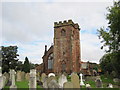
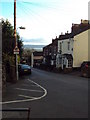
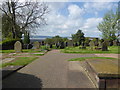
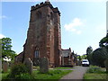
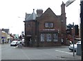
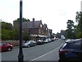
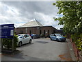
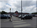
Your daily routine in CH60 0DW benefits from a diverse range of amenities within practical reach, catering to shopping, travel, and leisure needs. Five retail venues operate close to the cluster, including the Tesco Wirral, Cook Heswall, and Aldi Gayton, all located in accessible commercial zones. These supermarkets form the cornerstone of weekly shopping requirements, offering convenience without the need for long drives. Transport connectivity is supported by five nearby rail stations, with Heswall Railway Station serving as the most obvious local hub, alongside Neston Railway Station and Upton Railway Station. If sea travel interests you, the Woodside Birkenhead Ferry Terminal provides a direct link to Chester, situated just beyond this immediate postcode. Resorting to the wider community of Heswall reveals additional diversity; the upper village bustles with restaurants and takeaways, ensuring your evening dining needs are met locally. The lower village, designated a conservation area in April 1979, maintains a quieter, quaint atmosphere suited to relaxation. You can enjoy Sauvage Dales, a Site of Special Interest featuring lowland heath, or visit the 500-year-old tower of St Peter's Parish Church for historical interest. The presence of Heswall Primary School, established in 1909, signals a residential focus around education and family life. This blend of commercial utility and historic preservation creates a lifestyle where convenience and community character coexist harmoniously.
Amenities
Schools
| Rank | School | Type | Entry gender | Ages |
|---|
Explore more schools in this area
Go to Schools tabDemographics
The community within CH60 0DW reflects a stable, established population where adults form the backbone of society. Residents are predominantly White, indicating a homogenous community structure typical of this part of the Wirral. The demographic profile shows that most homeowners fall within the 30 to 64-year-old age range, with a median age of 47 years across the postcode. This indicates that the area is not a destination for young families just starting out or retirees moving for the first time, but rather a hub for established households with significant time spent in the locality. Security of tenure is extremely high, with 75% of residents owning their homes outright. This significant rate of home ownership suggests a deep-rooted community where families have long-term plans for the area. Across the wider Heswall area, over half of the residents own their property, reinforcing the trend towards stability found in your immediate cluster. The accommodation stock consists almost entirely of houses, fitting the profile of a suburban village rather than a high-rise urban zone. You will not find high-rise blocks or large apartment developments here; instead, you are surrounded by detached and semi-detached properties typical of a conservation area. There is no indication of deprivation impacting the quality of life in this specific cluster, as the population metrics suggest a prosperous, steady environment where long-term planning dominates financial decisions.
Household Size
Accommodation Type
Tenure
Ethnic Group
Religion
Household Composition
Age
Household Deprivation
NS-SEC
Explore more demographic insights in this area
Go to Demographics tabPlanning
Planning Constraints
- Flood RiskPremium
- Ramsar Wetland SitesPremium
- Area of Outstanding Natural BeautyPremium
- Protected Nature ReservePremium
- Protected WoodlandPremium