Area Overview for CH3 7AG
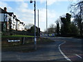
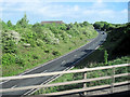
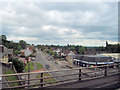
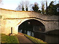
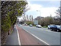
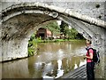
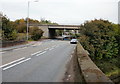
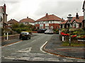
Photos of CH3 7AG

Area Information
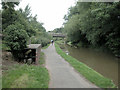
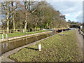
Living in CH3 7AG means residing within Christleton, a village and civil parish situated on the outskirts of Chester. This specific postcode covers a small residential cluster spanning just 2.7 hectares. It is home to 1,505 people, creating a feel that is intimate yet close to urban facilities. The area retains a distinct rural character defined by proximity to the Shropshire Union Canal and historic landmarks like Christleton Old Hall and St James Church. Christleton is known for its well-maintained atmosphere and has been named one of the best places to live in Cheshire and the North West by The Sunday Times in 2022 and 2024. The Sunday Times also recognised it as the best kept village in Cheshire between 2001 and 2004. Daily life here balances suburban accessibility with the charm of a historic settlement. Residents enjoy a setting described as desirable, featuring community amenities such as local pubs, a sports centre, and a swimming pool. The presence of features like Christleton Pit pond adds to the natural appeal for families seeking wildlife and outdoor enjoyment within their immediate neighbourhood.
- Area Type
- Postcode
- Area Size
- 2.7 hectares
- Population
- 1505
- Population Density
- 666 people/km²
The property market in CH3 7AG is defined by a strong inclination towards home ownership. Seventy-nine percent of residents own their homes, creating an environment where property values are likely influenced by long-term security and community roots. Houses form the primary accommodation type, meaning buyers will predominantly find detached or semi-detached properties rather than flats or apartments. This housing stock suits families and professionals who require space and autonomy. As a small residential cluster covering only 2.7 hectares, CH3 7AG operates as a tight-knit market where individual homes command attention. The high concentration of owner-occupiers suggests that the area appeals to those seeking stability rather than short-term rental potential. For buyers looking at this postcode, the demographic skew towards adults aged 30 to 64 years reinforces the suitability of the housing for those entering their family-building or mid-life stages. The lack of rental dominance further differentiates this location from typical high-density urban postcodes.
House Prices in CH3 7AG
Showing 19 properties
| Address | Type | Beds | Baths | Last Sale Price | Last Sale Date | |
|---|---|---|---|---|---|---|
| Ivy House, Pepper Street, Christleton, Chester, CH3 7AG | Terraced | - | - | £1,200,000 | Apr 2022 | |
| College House, Pepper Street, Christleton, Chester, CH3 7AG | Detached | 5 | 4 | £400,000 | Jan 2022 | |
| Church View, Pepper Street, Christleton, Chester, CH3 7AG | house | - | - | £665,000 | Jun 2020 | |
| Christleton House, Pepper Street, Christleton, Chester, CH3 7AG | Semi-detached | 5 | 3 | £3,000,000 | Apr 2019 | |
| Red House, Pepper Street, Christleton, Chester, CH3 7AG | Detached | 4 | 1 | £495,000 | Dec 2018 | |
| Rock Cottage, Pepper Street, Christleton, Chester, CH3 7AG | house | - | - | £363,000 | Sep 2016 | |
| Yew Tree View, Pepper Street, Christleton, Chester, CH3 7AG | Terraced | 2 | 1 | £214,750 | Oct 2013 | |
| Lamorna, Pepper Street, Christleton, Chester, CH3 7AG | house | - | - | £390,000 | Nov 2007 | |
| Pear Tree Cottage, Pepper Street, Christleton, Chester, CH3 7AG | Terraced | - | - | £245,000 | Mar 2001 | |
| Fern Cottage, Pepper Street, Christleton, Chester, CH3 7AG | Semi-detached | - | - | £120,000 | Nov 1998 |
Energy Efficiency in CH3 7AG
Daily life in CH3 7AG is supported by a range of amenities within practical reach. Retail needs are met by five local options, including Sainsburys Chester, Spar, and Co-op Chester. These venues provide essential shopping for groceries and household necessities without requiring lengthy journeys. Transport connectivity is reinforced by three railway stations in the vicinity: Chester Railway Station, Bache Railway Station, and Mouldsworth Railway Station. These stations facilitate easy access to wider regions beyond the immediate village. Residents also benefit from proximity to Hawarden Airport, the sole airport listed nearby. Local leisure facilities include pubs such as Ring O' Bells, Cheshire Cat, and Plough, which serve as community hubs. Cultural and historical landmarks add to the lifestyle, including Christleton Old Hall, a Grade II* listed building from the early 17th century. Residents can stroll along the Shropshire Union Canal towpath or visit Christleton Pit pond. This blend of retail convenience, transport links, and historic charm defines the resident experience in Christleton.
Amenities
Schools
Families considering homes in CH3 7AG have access to highly rated educational institutions immediately nearby. Christleton Primary School stands as the key educational option listed for the area. It operates as a primary school and holds an outstanding Ofsted rating. This high standard of Ofsted performance provides assurance regarding the quality of early education available to residents. While the data lists only one school, the presence of an outstanding-rated primary institution serves as a central educational pillar for the local family demographic. The school is situated within the close-knit community, reinforcing the localised nature of education provision in Christleton. For younger children living in CH3 7AG, this means they can access top-tier primary education without needing to travel far. The specific rating suggests that the curriculum and facilities meet rigorous national standards, which is a significant factor for parents evaluating area-specific education options.
| Rank | School | Type | Entry gender | Ages |
|---|
Explore more schools in this area
Go to Schools tabDemographics
The community in CH3 7AG consists primarily of adults aged between 30 and 64 years. This age group represents the most common demographic living in the area. The median age of residents is 47 years, reflecting a mature population profile. Home ownership is exceptionally high, with 79% of households owning their property outright or with a mortgage. This contrasts with the shared ownership or rental markets found in many other urban locations. The predominant form of accommodation consists of houses, which aligns with the village character of Christleton. The ethnic composition is predominantly White, mirroring the traditional structure of many established Cheshire settlements. With a population density of 666 people per square kilometre, the area maintains a residential quality without excessive crowding. This demographic profile suggests stability for families and professionals seeking a quiet environment. The high rate of home ownership indicates long-term community integration rather than transient housing trends.
Household Size
Accommodation Type
Tenure
Ethnic Group
Religion
Household Composition
Age
Household Deprivation
NS-SEC
Explore more demographic insights in this area
Go to Demographics tabPlanning
Planning Constraints
- Flood RiskPremium
- Ramsar Wetland SitesPremium
- Area of Outstanding Natural BeautyPremium
- Protected Nature ReservePremium
- Protected WoodlandPremium