Area Overview for BB12 8DR
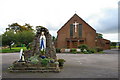
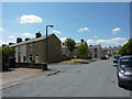
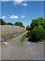
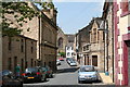
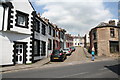
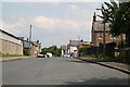
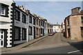
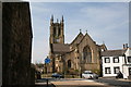
Photos of BB12 8DR
Area Information
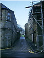
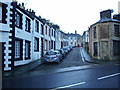
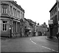
BB12 8DR is a small residential cluster in Lancashire, nestled within the Borough of Burnley. This area covers 7,492 square metres and is home to 1,623 people, making it one of the most densely populated regions in England, with 216,643 people per square kilometre. Historically a market town, Padiham retains its character as a conservation area, with origins tracing back to an Anglo-Saxon settlement. The town’s centre is defined by its River Calder and proximity to Pendle Hill, offering a blend of natural and historical interest. Daily life here is shaped by its compact size and strong local identity. Residents benefit from nearby rail links, including Hapton and Burnley Barracks stations, and proximity to the Leeds and Liverpool Canal. The area’s demographics reflect a mature population, with a median age of 47, and a community rooted in traditional industries like cotton weaving and coal mining. Despite its small scale, BB12 8DR combines practical living with a sense of heritage, making it a distinct choice for those seeking a close-knit, historically rich environment.
- Area Type
- Postcode
- Area Size
- 7492 m²
- Population
- 1623
- Population Density
- 4332 people/km²
The property market in BB12 8DR is characterised by a 43% home ownership rate, which is below the national average and suggests a significant proportion of the housing stock is rented out. The accommodation type is predominantly houses, reflecting the area’s small, residential nature and likely contributing to a more family-oriented demographic. Given the compact size of the postcode and its classification as a residential cluster, the housing stock is likely limited in both quantity and variety. This could mean that buyers seeking properties in BB12 8DR may need to consider nearby areas for more options. The predominance of houses also implies a focus on traditional, possibly older properties, which may require renovation or adaptation to modern needs. For those considering purchase, the relatively low home ownership rate could indicate a competitive rental market, but the small area’s proximity to Burnley and its transport links may offer broader opportunities for those willing to explore surrounding regions.
House Prices in BB12 8DR
Showing 70 properties
| Address | Type | Beds | Baths | Last Sale Price | Last Sale Date | |
|---|---|---|---|---|---|---|
| 50 Ingham Street, Padiham, BB12 8DR | Terraced | 2 | 1 | £63,000 | Jul 2025 | |
| 10 Ingham Street, Padiham, BB12 8DR | Terraced | 2 | 1 | £62,500 | Apr 2025 | |
| 61 Ingham Street, Padiham, BB12 8DR | Terraced | 2 | 1 | £1,245 | Jan 2025 | |
| 43 Ingham Street, Padiham, BB12 8DR | Terraced | 2 | 1 | £75,000 | Nov 2024 | |
| 25 Ingham Street, Padiham, BB12 8DR | Terraced | 2 | 1 | £62,500 | Nov 2024 | |
| 6 Ingham Street, Padiham, BB12 8DR | Terraced | 2 | 1 | £50,000 | Oct 2024 | |
| 22 Ingham Street, Padiham, BB12 8DR | Terraced | 2 | 1 | £60,000 | May 2024 | |
| 27 Ingham Street, Padiham, BB12 8DR | Terraced | 2 | 1 | £39,950 | Apr 2024 | |
| 57 Ingham Street, Padiham, BB12 8DR | house | - | - | £39,950 | Apr 2024 | |
| 66 Ingham Street, Padiham, BB12 8DR | house | - | - | £39,950 | Mar 2024 |
Energy Efficiency in BB12 8DR
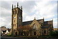
Living in BB12 8DR offers access to a range of local amenities within practical reach. Retail options include Lidl Padiham, Tesco Padiham, and Spar, providing everyday shopping convenience. The area’s rail connections, such as Hapton and Burnley Barracks stations, facilitate easy travel to nearby towns and cities. Historically, Padiham was a market town, and its conservation area status preserves its architectural heritage, with landmarks like St Leonard’s Parish Church and Victoria Mill adding character to the landscape. The River Calder and proximity to Pendle Hill offer natural scenery, though no specific parks or recreational facilities are detailed in the data. The compact size of the area means that amenities are closely clustered, reducing the need for long commutes. The mix of retail, transport, and historical sites creates a lifestyle that balances practicality with local charm, appealing to those who value accessibility and a sense of community.
Amenities
Schools
| Rank | School | Type | Entry gender | Ages |
|---|
Explore more schools in this area
Go to Schools tabDemographics
The population of BB12 8DR has a median age of 47, with the majority of residents aged between 30 and 64 years. This suggests a community with a strong presence of middle-aged adults, potentially reflecting the area’s historical ties to industry and the gradual shift in economic activity. Home ownership stands at 43%, indicating a mix of owner-occupied and rental properties, though the latter may be more prevalent given the lower figure. The predominant accommodation type is houses, which aligns with the area’s residential character and smaller scale. The dominant ethnic group is White, though no specific data on diversity or minority representation is provided. The high population density, combined with a mature age profile, may influence the social dynamics and local services. While no explicit data on deprivation is available, the relatively low home ownership rate could suggest a reliance on rental housing, which may impact long-term stability for some residents.
Household Size
Accommodation Type
Tenure
Ethnic Group
Religion
Household Composition
Age
Household Deprivation
NS-SEC
Explore more demographic insights in this area
Go to Demographics tabPlanning
Planning Constraints
- Flood RiskPremium
- Ramsar Wetland SitesPremium
- Area of Outstanding Natural BeautyPremium
- Protected Nature ReservePremium
- Protected WoodlandPremium