Area Overview for SE6 1HP
Photos of SE6 1HP

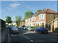
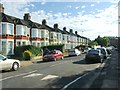
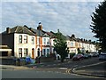
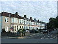
84 photos from this area
Area Information
Key information about the SE6 1HP including its size, population, and administrative classification.
- Area Type
- Postcode
- Area Size
- 2.2 hectares
- Population
- 1668
- Population Density
- 9287 people/km²
House Prices in SE6 1HP
70
Properties
£471,968
Average Sold Price
£78,850
Lowest Price
£1,250,000
Highest Price
Showing 70 properties
| Address | Type | Beds | Baths | Last Sale Price | Last Sale Date | |
|---|---|---|---|---|---|---|
| 155 Wellmeadow Road, London, SE6 1HP | house | 6 | 4 | £1,250,000 | May 2024 | |
| 142 Wellmeadow Road, London, SE6 1HP | Terraced | 2 | 1 | £900,000 | Jul 2023 | |
| 153 Wellmeadow Road, London, SE6 1HP | house | - | - | £720,000 | Feb 2023 | |
| 162 Wellmeadow Road, London, SE6 1HP | Terraced | 3 | - | £698,000 | Nov 2019 | |
| 124 Wellmeadow Road, London, SE6 1HP | Terraced | 6 | - | £760,000 | Oct 2019 | |
| 135A Wellmeadow Road, London, SE6 1HP | Flat | 1 | 1 | £425,000 | Jan 2019 | |
| 158 Wellmeadow Road, London, SE6 1HP | Terraced | 4 | 2 | £750,000 | Oct 2016 | |
| 128 Wellmeadow Road, London, SE6 1HP | Terraced | 5 | 3 | £700,000 | Oct 2014 | |
| 122 Wellmeadow Road, London, SE6 1HP | Semi-detached | 6 | 3 | £405,000 | Jul 2009 | |
| 135 Wellmeadow Road, London, SE6 1HP | house | - | - | £320,000 | Jun 2009 |
Page 1 of 7
Energy Efficiency in SE6 1HP
Amenities
Schools
| Rank | School | Type | Entry gender | Ages |
|---|
Explore more schools in this area
Go to Schools tabDemographics
Household Size
Family (3-5 people)
most common
Accommodation Type
Houses
most common
Tenure
54
majority
Ethnic Group
White
most common
Religion
N/A
most common
Household Composition
N/A
most common
Age
47
median
Adults (30-64 years)
most common
Household Deprivation
N/A
with no deprivation
NS-SEC
39
in Lower managerial occupations
Explore more demographic insights in this area
Go to Demographics tabPlanning
Planning Constraints
- Flood RiskPremium
- Ramsar Wetland SitesPremium
- Area of Outstanding Natural BeautyPremium
- Protected Nature ReservePremium
- Protected WoodlandPremium