Area Overview for HA0 2SS
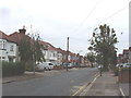
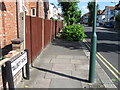
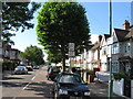
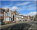
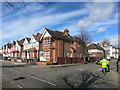
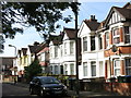
Photos of HA0 2SS


Area Information
HA0 2SS is a compact residential postcode in England, covering 8,056 square metres and home to 1,766 residents. Its high population density—219,210 people per square kilometre—reflects a tightly knit community, where proximity to amenities and services is a defining feature. The area is characterised by a predominance of houses, with a notable presence of Asian communities shaping its cultural fabric. Daily life here is shaped by ease of access to transport hubs, retail outlets, and schools. Residents benefit from a mix of local shops, including Tesco and Iceland, and multiple rail and metro stations within reach. While the area is small, its strategic location near Sudbury and Wembley ensures connectivity to broader urban networks. For those seeking a balance between suburban comfort and urban convenience, HA0 2SS offers a compact, functional living environment with a distinct local identity.
- Area Type
- Postcode
- Area Size
- 8056 m²
- Population
- 1766
- Population Density
- 6901 people/km²
HA0 2SS is a small area with a housing stock dominated by houses, though home ownership is relatively low at 45%. This implies that the market is more rental-oriented than owner-occupied, which could affect property value growth and buyer demand. The limited size of the postcode means the housing stock is concentrated, potentially making competition for available homes fierce. For buyers, this could mean limited options, but proximity to amenities like retail hubs and transport links may offset this. The predominance of houses suggests a preference for family homes, though the lower ownership rate indicates a reliance on private rentals. Prospective buyers should consider the area’s compact nature and focus on proximity to essential services when evaluating properties.
House Prices in HA0 2SS
Showing 1 properties
| Address | Type | Beds | Baths | Last Sale Price | Last Sale Date | |
|---|---|---|---|---|---|---|
| Royal Mail, Sea Cadets, 607 Harrow Road, Wembley, HA0 2SS | Leisure | - | - | - | - |
Energy Efficiency in HA0 2SS
HA0 2SS offers a range of amenities within practical reach, enhancing daily life. Local retail options include Tesco Sudbury, Iceland Wembley, and Tesco Wembley, providing convenience for shopping. Transport hubs like Sudbury & Harrow Road Station and Alperton Station ensure easy access to public transport, while ferry stops such as Kew Pier offer alternative routes. The area’s proximity to RAF Northolt adds a unique dimension to its character. For leisure, the presence of multiple stations and retail outlets suggests a dynamic environment, though green spaces or parks are not explicitly mentioned. The mix of retail, transport, and military infrastructure creates a functional, accessible lifestyle, ideal for those prioritising convenience over sprawling natural landscapes.
Amenities
Schools
The nearest school to HA0 2SS is Barham Primary School, which has a good Ofsted rating. This primary school serves the local community, offering a solid foundation for younger children. However, the data does not list secondary schools in the immediate vicinity, which may require families to look beyond the postcode for comprehensive education. The presence of a well-rated primary school is a significant draw for families, though the absence of secondary options could be a consideration for those prioritising a single-school catchment. The school’s rating reflects a commitment to quality education, but parents should plan for additional travel if secondary schooling is needed.
| Rank | School | Type | Entry gender | Ages |
|---|
Explore more schools in this area
Go to Schools tabDemographics
The population of HA0 2SS skews towards adults aged 30–64, with a median age of 47. This suggests a community of established professionals and families, rather than a younger or elderly demographic. Home ownership rates stand at 45%, meaning over half of residents rent their homes, indicating a rental market that may cater to transient or younger demographics. The area is predominantly composed of houses, which contrasts with higher-density housing types. The predominant ethnic group is Asian, reflecting a cultural diversity that influences local businesses and community dynamics. While deprivation data is not specified, the high population density and mix of ownership types suggest a mix of economic profiles. The presence of a primary school with a good Ofsted rating further underscores the area’s appeal to families seeking stability.
Household Size
Accommodation Type
Tenure
Ethnic Group
Religion
Household Composition
Age
Household Deprivation
NS-SEC
Explore more demographic insights in this area
Go to Demographics tabPlanning
Planning Constraints
- Flood RiskPremium
- Ramsar Wetland SitesPremium
- Area of Outstanding Natural BeautyPremium
- Protected Nature ReservePremium
- Protected WoodlandPremium