Area Overview for CR4 1JH
Photos of CR4 1JH

Area Information
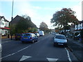
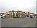
Longthornton is a specific postcode cluster within the London Borough of Merton, defined by the CR4 1JH code. You will find 2,390 residents living across 7,114 square metres, which creates a tightly packed but distinctly residential environment. While the area is officially described as a small residential cluster, its history stretches back to the late 1920s when the Long Thornton Park Estate opened on former market gardens owned by the Marchant and Mizen families. The area was built under the Small Dwellings Acquisitions Acts, a government scheme designed to encourage house ownership among working families. Residents initially formed a Ratepayers' Association in 1927 to demand basic infrastructure, including better roads and lighting, which they successfully secured from the 1929. Today, this 1920s estate remains a core part of the Mitcham district, offering a sense of continuity that modern developments often lack. Living in CR4 1JH means being part of a community forged over a century ago, where the physical layout still reflects the original planning decisions made nearly 100 years ago. The area sits comfortably within the broader Mitcham ward, electing councillors who have represented the locality since 1978.
- Area Type
- Postcode
- Area Size
- 7114 m²
- Population
- 2390
- Population Density
- 10978 people/km²
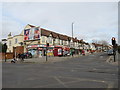
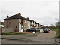
The property market in CR4 1JH is defined by the dominance of houses, which account for the primary accommodation type in the area. You will find that 66% of homes are owned outright or with a mortgage, meaning the stock is largely owner-occupied. This high level of sentimentality often translates to properties that have been extended or renovated over generations rather than recently rebuilt. Because the area contains specific postcode clusters with such high ownership rates, buyers looking at CR4 1JH should expect to compete in a seller's market. The lack of listed flats or apartments reinforces the character of the Long Thornton Park Estate, which was built specifically for detached or semi-detached family living. If you are purchasing a home in this postcode, you are likely acquiring a property with a history that dates back to the 1926 construction boom. The density of 335,940 people per square kilometre is actually very high for a house-dominated area, indicating the buildings are situated very close to one another. This proximity creates a quiet but active street life, unlike the wide, spaced-out properties you might find on the outskirts. You are buying into an established stock rather than a new build community.
House Prices in CR4 1JH
Showing 27 properties
| Address | Type | Beds | Baths | Last Sale Price | Last Sale Date | |
|---|---|---|---|---|---|---|
| 203 Manor Road, Mitcham, CR4 1JH | Detached | 3 | 1 | £467,500 | Nov 2023 | |
| 195 Manor Road, Mitcham, CR4 1JH | Terraced | 3 | 2 | £575,000 | Jun 2022 | |
| 179 Manor Road, Mitcham, CR4 1JH | Flat | - | - | £420,000 | Jun 2021 | |
| 187 Manor Road, Mitcham, CR4 1JH | Terraced | 3 | 1 | £390,000 | Dec 2018 | |
| 205 Manor Road, Mitcham, CR4 1JH | Terraced | 3 | - | £320,000 | Aug 2014 | |
| 207A Manor Road, Mitcham, CR4 1JH | Flat | - | - | £195,000 | Aug 2013 | |
| 175 Manor Road, Mitcham, CR4 1JH | house | - | - | £210,000 | Sep 2009 | |
| 199 Manor Road, Mitcham, CR4 1JH | Terraced | - | - | £183,000 | May 2003 | |
| 189 Manor Road, Mitcham, CR4 1JH | Terraced | - | - | £175,000 | Jun 2002 | |
| 213A Manor Road, Mitcham, CR4 1JH | Flat | - | - | £45,000 | Mar 2002 |
Energy Efficiency in CR4 1JH
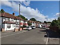
Daily life in CR4 1JH revolves around a network of nearby amenities that keep essential services within practical reach. Five retail outlets are situated close to the postcode, including Co-op South, Lidl Rowan, and Iceland Norbury. These specific venues provide daily food and shopping needs without requiring a long drive. For transport links, five railway stations and five tram stops serve the wider Longthornton area, placing you in the heart of Merton's transport web. Five ferry terminals are also listed as nearby options, though these are further away on the Thames. If you prefer to drive, two major coach stations including Victoria Coach Station and Green Line Coach Station are accessible from the zone. The 2390 residents live in an area where these five shopping options and five rail nodes create a convenient radius. You can walk or take a short bus ride to reach Co-op South or Lidl Rowan for groceries. The presence of five tram stops like Beddington Lane and Mitcham Tram Stop ensures you have flexible public transport options for commuting. This density of services supports the 66% ownership rate by making independent living feasible without needing a private car for every errand.
Amenities
Schools
| Rank | School | Type | Entry gender | Ages |
|---|
Explore more schools in this area
Go to Schools tabDemographics
The community profile for CR4 1JH shows a mature population with a median age of 47. Most common age ranges include adults between 30 and 64 years, suggesting a neighbourhood where many residents are established families or professionals at the peak of their careers. House ownership stands at a solid 66%, indicating a stable, settled population rather than a transient rental market. Because streets in this ward are filled with houses rather than apartments or flats, the street life feels different from newer London towns. The predominant ethnic group in Longthornton is White, which aligns with the historical development of the estate in the interwar period. You should expect a environment where the original demographic makeup persists alongside new arrivals. The high home ownership rate of 66% correlates directly with the accommodation type, which consists almost entirely of houses. This combination suggests a area where people buy to stay rather than rent to roam. With three councillors elected to Merton Council, the ward has a strong voice in local decision making, further reflecting the long-term commitment of the population.
Household Size
Accommodation Type
Tenure
Ethnic Group
Religion
Household Composition
Age
Household Deprivation
NS-SEC
Explore more demographic insights in this area
Go to Demographics tabPlanning
Planning Constraints
- Flood RiskPremium
- Ramsar Wetland SitesPremium
- Area of Outstanding Natural BeautyPremium
- Protected Nature ReservePremium
- Protected WoodlandPremium