Area Overview for BR1 2UB
Photos of BR1 2UB
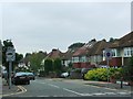
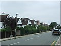
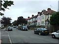
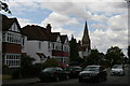
53 photos from this area
Area Information
Key information about the BR1 2UB including its size, population, and administrative classification.
- Area Type
- Postcode
- Area Size
- 2.1 hectares
- Population
- Not available
- Population Density
- Not available
House Prices in BR1 2UB
30
Properties
£589,463
Average Sold Price
£175,000
Lowest Price
£1,175,000
Highest Price
Showing 30 properties
| Address | Type | Beds | Baths | Last Sale Price | Last Sale Date | |
|---|---|---|---|---|---|---|
| 8 Serviden Drive, Bromley, BR1 2UB | house | 4 | - | £1,175,000 | Aug 2024 | |
| 30 Serviden Drive, Bromley, BR1 2UB | Detached | 5 | 3 | £1,125,000 | Jan 2021 | |
| 24 Serviden Drive, Bromley, BR1 2UB | house | - | - | £685,000 | Sep 2020 | |
| 36 Serviden Drive, Bromley, BR1 2UB | house | - | - | £690,000 | Oct 2017 | |
| 15 Serviden Drive, Bromley, BR1 2UB | Detached | 5 | 2 | £605,000 | Jan 2016 | |
| 7 Serviden Drive, Bromley, BR1 2UB | Detached | 4 | 2 | £675,000 | Jun 2015 | |
| 20 Serviden Drive, Bromley, BR1 2UB | Detached | 4 | 2 | £700,000 | May 2015 | |
| 22 Serviden Drive, Bromley, BR1 2UB | Detached | 4 | - | £640,000 | Sep 2014 | |
| 6 Serviden Drive, Bromley, BR1 2UB | Detached | 4 | - | £765,000 | May 2014 | |
| 18 Serviden Drive, Bromley, BR1 2UB | Detached | 4 | - | £710,000 | Dec 2013 |
Page 1 of 3
Energy Efficiency in BR1 2UB
Amenities
Schools
| Rank | School | Type | Entry gender | Ages |
|---|
Explore more schools in this area
Go to Schools tabDemographics
Household Size
Family (3-5 people)
most common
Accommodation Type
Houses
most common
Tenure
81
majority
Ethnic Group
White
most common
Religion
N/A
most common
Household Composition
N/A
most common
Age
47
median
Adults (30-64 years)
most common
Household Deprivation
N/A
with no deprivation
NS-SEC
53
in Lower managerial occupations
Explore more demographic insights in this area
Go to Demographics tabPlanning
Planning Constraints
- Flood RiskPremium
- Ramsar Wetland SitesPremium
- Area of Outstanding Natural BeautyPremium
- Protected Nature ReservePremium
- Protected WoodlandPremium