Area Overview for NR20 3AE
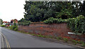
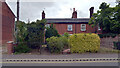
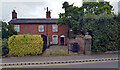
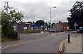
Photos of NR20 3AE
Area Information
Living in NR20 3AE means residing in a compact residential cluster within England. This postcode covers just 1.9 hectares, creating a tight-knit environment for its 1,433 residents. With a population density of 76,070 people per square kilometre, you will find houses packed closely together. This high density suggests a neighbourhood where front doors are near neighbours' doors. The area functions as a small residential extension to the broader town of Dereham. Daily life here involves navigating a concentrated settlement rather than a sprawling suburb. You are living in a district defined by its specific postal code, which places you close to local infrastructure while maintaining a distinct identity. The sheer number of people per hectare indicates a built-up environment where space between properties is limited. This character shapes the rhythm of life, fostering immediate community interaction but offering less private outdoor space compared to rural areas. Prospective buyers purchasing homes in NR20 3AE should expect a character that reflects this intense residential focus. The area serves as a functional part of the local housing stock, catering to those who prioritise proximity to town centres over spacious gardens.
- Area Type
- Postcode
- Area Size
- 1.9 hectares
- Population
- 1433
- Population Density
- 4719 people/km²
The market in NR20 3AE is defined by a landscape of houses rather than apartments or flats. With 57% of the population owning their homes, this postcode represents an area where renting is not the primary housing mode. This high ownership percentage indicates that homeowners have established deep roots in the local neighbourhood. The accommodation type is strictly houses, so buyers seeking bungalows or semi-detached homes are the natural fit for this location. While specific price data is absent from the provided records, the high density of 76,070 people per square kilometre suggests that property values reflect the tight supply of housing on this small 1.9-hectare footprint. Long-term ownership rates often correlate with lower transient turnover, meaning properties tend to change hands less frequently. This stability can be attractive to buyers looking for a settled community rather than a high-turnover rental market. The concentration of house ownership means you are more likely to find families who have remained in the area for significant periods. This environment suits buyers who value stability and established neighbourliness over the pace of a bustling student quarter.
House Prices in NR20 3AE
Showing 35 properties
| Address | Type | Beds | Baths | Last Sale Price | Last Sale Date | |
|---|---|---|---|---|---|---|
| 17A Norwich Road, Dereham, NR20 3AE | Detached | 4 | 3 | £485,000 | Jan 2025 | |
| 24 Norwich Road, Dereham, NR20 3AE | Terraced | 2 | 1 | £180,000 | Dec 2024 | |
| 2 Norwich Road, Dereham, NR20 3AE | house | - | - | £190,000 | Feb 2024 | |
| 12 Norwich Road, Dereham, NR20 3AE | Terraced | 2 | 1 | £129,000 | Jan 2024 | |
| 20 Norwich Road, Dereham, NR20 3AE | Terraced | 2 | 1 | £162,000 | Dec 2023 | |
| 6 Norwich Road, Dereham, NR20 3AE | house | - | - | £190,000 | Jan 2023 | |
| 18 Norwich Road, Dereham, NR20 3AE | house | - | - | £140,000 | Aug 2022 | |
| 22 Norwich Road, Dereham, NR20 3AE | house | 2 | - | £215,000 | Dec 2021 | |
| 40 Norwich Road, Dereham, NR20 3AE | house | 2 | 1 | £190,000 | Jun 2021 | |
| 11 Norwich Road, Dereham, NR20 3AE | house | 2 | - | £235,000 | Jan 2021 |
Energy Efficiency in NR20 3AE
Your daily life in NR20 3AE relies heavily on amenities within the nearby town of Dereham. The nearest metro area is Dereham itself, which acts as the primary centre for larger shopping and leisure activities. Within practical reach, you have five notable retail options to visit for groceries and household needs. Morrisons Scarning offers supermarket shopping, while Iceland East provides an alternative retail choice for food and beverages. M&S Lynn Hill BP adds access to major high street brands and possibly fuel. These specific venues are the main commercial anchors for residents of NR20 3AE. Because the postcode is only 1.9 hectares, you will not find large shopping centres on-site. Instead, you commute short distances to Dereham to access libraries, cinemas, and extensive retail parks. The retail density of five named outlets suggests a convenient local network without being overwhelming. Your lifestyle involves a quick trip from your home to these known retail destinations for all daily necessities. This setup ensures that errands are manageable while you enjoy the quieter residential hours back in your own property.
Amenities
Schools
Families living in NR20 3AE have access to several institutions for their children's education. The closest primary education is provided by King's Park Infant School in Dereham. This institution operates as both an academy and a standard primary school, indicating its integration into the national academy trust system. For older children, Dereham Sixth Form College offers education after the age of 16. These named schools form the immediate educational catchment or travel route for residents. The mix of infant schooling and sixth-form education means that younger children and teenagers both have options nearby, though the distance between NR20 3AE and Dereham requires travel. King's Park Infant School serves the younger demographic, ensuring early years are covered by a recognised local provider. Dereham Sixth Form College caters to secondary-aged students, providing a pathway for older children in the NR20 3AE community. You must plan travel to these specific named schools as they are located in Dereham rather than on the immediate small estate of the postcode itself. The reliance on these two distinct institutions means the area serves as a commuter hub for local schooling.
| Rank | School | Type | Entry gender | Ages |
|---|
Explore more schools in this area
Go to Schools tabDemographics
The community in NR20 3AE reflects a mature demographic profile. The median age stands at 47 years, with adults aged between 30 and 64 years being the most common age range. This indication suggests a settlement dominated by families and established households rather than young students or retirees. Ownership habits are significant here, with 57% of residents owning their homes outright or with a mortgage. This majority ownership rate points to a stable community where long-term residents often hold equity in their properties. The predominant ethnic group is White, which forms the majority of the population structure. Accommodation is exclusively in the form of houses, meaning you will not find flats or purpose-built apartments within this postcode. There is no record of deprivation data for this area in the available records, so the focus remains on the clear housing and age statistics. The high density and mature age profile create a quiet atmosphere typical of areas settled by families in their middle years. You are looking at a community where the older generation and those raising children in their younger years make up the bulk of the local population.
Household Size
Accommodation Type
Tenure
Ethnic Group
Religion
Household Composition
Age
Household Deprivation
NS-SEC
Explore more demographic insights in this area
Go to Demographics tabPlanning
Planning Constraints
- Flood RiskPremium
- Ramsar Wetland SitesPremium
- Area of Outstanding Natural BeautyPremium
- Protected Nature ReservePremium
- Protected WoodlandPremium