Area Overview for NR12 8GB
Photos of NR12 8GB

Area Information
Living in NR12 8GB offers a quiet residential experience within a compact 6.7-hectare cluster. This specific postcode serves 2,298 people, creating a small community where neighbours are likely to know one another. The setting is distinctively sparse, with a population density of only 154 people per square kilometre. Such low density implies ample space and a lack of urban congestion compared to larger towns like Norwich. You will find yourself surrounded by houses rather than high-rise blocks or dense apartment developments. The area functions as a calm retreat, suitable for those seeking a slower pace of life away from the bustling city centre. Daily routines here involve navigating a close-knit neighbourhood where the scale of development remains manageable. While the area is small, it provides a stable foundation for long-term residence. The limited size suggests a focused community environment where local services and interactions revolve around nearby landmarks. Residents experience a lifestyle defined by proximity to the village of Wroxham and easy access to the East Coast Main Line railway network. The character of NR12 8GB is shaped by its historic location, existing primarily as a housing estate before development. This postcode represents a specific slice of Norfolk real estate that balances rural context with essential urban connectivity.
- Area Type
- Postcode
- Area Size
- 6.7 hectares
- Population
- 2298
- Population Density
- 154 people/km²
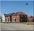
The property market in NR12 8GB is defined by a strong preference for owner-occupied housing. With 74% of households owning their homes, this area functions primarily as a retirement or settled family district rather than a student or transient rental hub. The accommodation stock is predominantly houses, which aligns with the high ownership rate and the absence of high-density apartment blocks. This structure appeals to buyers seeking a slice of the Norfolk countryside but with established Permitted Development Status and guaranteed services. The low population density of 154 people per square kilometre further suggests that there is little pressure to convert land into high-rise rentals. You will find that properties here offer garden space and single-storey living options that suit the older demographic. The fact that the median age is 47 means that the existing investment in these houses has been significant and stable. Buyers looking at homes in NR12 8GB should expect a market where sellers are likely long-term owners rather than developers flipping homes quickly. The character of the neighbourhood supports individual homeownership models rather than large shared-ownership schemes. This stability makes the area attractive to those who wish to buy with the intention of staying for decades rather than a few years.
House Prices in NR12 8GB
Showing 5 properties
| Address | Type | Beds | Baths | Last Sale Price | Last Sale Date | |
|---|---|---|---|---|---|---|
| 5 Reedham Drive, Hoveton, NR12 8GB | Detached | 4 | 2 | £447,500 | Nov 2024 | |
| 1 Reedham Drive, Hoveton, NR12 8GB | Detached | 4 | 2 | £380,000 | May 2024 | |
| 3 Reedham Drive, Hoveton, NR12 8GB | house | - | - | £274,950 | Jun 2014 | |
| 4 Reedham Drive, Hoveton, NR12 8GB | house | - | - | £299,950 | Jun 2014 | |
| 2 Reedham Drive, Hoveton, NR12 8GB | house | - | - | - | - |
Energy Efficiency in NR12 8GB
Residents of NR12 8GB enjoy direct access to a range of practical amenities within practical reach of the estate. You can shop for groceries and daily necessities at several locations, including East of England Co-operative Co, Tesco Norwich, and Morrisons Daily. These retailers provide comprehensive supplies without the need for long journeys into city centres. Transport planners are particularly well-served, as the area is adjacent to Wroxham, a major transportation hub. Three railway stations serve the wider locality: Hoveton & Wroxham Railway Station, Salhouse Railway Station, and Worstead Railway Station. Owning a car is not strictly necessary for travel, though it remains convenient given the spread of the 6.7-hectare cluster. For leisure and dining, Wroxham offers a wider selection of restaurants and pubs compared to the immediate postcode boundary. The presence of these specific amenities ensures that daily errands are manageable and that essential services like fresh food are always available nearby. The lifestyle here is defined by convenience rather than spontaneity; you will return to the same reliable shops each week. This balance of local retail and major transport nodes supports a comfortable, low-stress daily routine for homeowners.
Amenities
Schools
Families considering schools near NR12 8GB have a selection of options within the local cluster. The nearest primary education provider is St John's Community Primary School and Nursery, which currently holds a Good rating from Ofsted. This institution offers a solid foundation for young children within the immediate vicinity. Other nearby educational facilities include Broadland High School and Broadland High Ormiston Academy, the latter functioning as an academy. This mix of primary and secondary/independent academy options ensures that residents have access to a broad curriculum without needing to travel far. The presence of multiple school types indicates that the area is entered into by families at various stages of their children's education. While statistics on pupil performance are not listed, the Good rating of St John's provides a verified standard of quality for younger students. Prospective buyers can plan their routes to these specific venues knowing they are established institutions. The proximity of these schools supports the lifestyle of the resident demographic, which includes many families with children despite the older median age. Access to these schools makes NR12 8GB a viable location for parents who require reliable, nearby education services for their children.
| Rank | School | Type | Entry gender | Ages |
|---|
Explore more schools in this area
Go to Schools tabDemographics
The resident profile of NR12 8GB is heavily weighted towards older generations. The median age stands at 47 years, which is notably higher than the national average. The most common age range comprises elderly residents aged 65 and over. This demographic structure creates a distinct community atmosphere focused on the needs of later-life living. Home ownership is the dominant norm, with 74% of households owning their residences. This high level of tenure suggests a population with deep local roots and long-term stability. The primary accommodation type throughout this cluster consists of houses, reinforcing the family-oriented and established nature of the street layout. The predominant ethnic group within the area is White, reflecting the traditional demographic composition of this part of Norfolk. These figures indicate a mature community rather than a transient rental sector. The high ownership rate also correlates with the prevalence of households where residents have built equity over many years. This demographic mix means local amenities and services are likely tailored to the preferences of older adults and permanent residents. Understanding these statistics helps you gauge the type of neighbourly interactions and community events you can expect when you move into this postcode.
Household Size
Accommodation Type
Tenure
Ethnic Group
Religion
Household Composition
Age
Household Deprivation
NS-SEC
Explore more demographic insights in this area
Go to Demographics tabPlanning
Planning Constraints
- Flood RiskPremium
- Ramsar Wetland SitesPremium
- Area of Outstanding Natural BeautyPremium
- Protected Nature ReservePremium
- Protected WoodlandPremium