Area Overview for CM9 5FJ
Photos of CM9 5FJ


Area Information
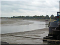
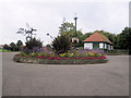
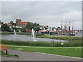
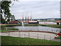
Living in CM9 5FJ, a small residential cluster in Essex, offers a compact, high-density environment with a population of 1,809 spread across 4,690 square metres. This postcode falls within the historic market town of Maldon, a place with Saxon origins and a legacy as a regional trade hub. The area’s proximity to the Blackwater Estuary and its medieval landmarks, such as St Peter’s Tower and All Saints’ Church, adds historical depth to daily life. The community here is predominantly middle-aged, with a median age of 47 and a strong presence of adults aged 30–64. Daily routines are shaped by the area’s small size, where residents can access nearby amenities, including retail outlets like M&S Maldon and railway stations such as Hatfield Peverel. The high population density means the area is tightly knit, though the compact nature may limit space for larger families. For those seeking a blend of history, convenience, and connectivity, CM9 5FJ offers a distinct blend of old-world charm and modern practicality.
- Area Type
- Postcode
- Area Size
- 4690 m²
- Population
- Not available
- Population Density
- Not available
The property market in CM9 5FJ is dominated by owner-occupied homes, with 54% of residents living in properties they own. This contrasts with the remaining 46% who may be renting, though the exact proportion of rental properties is not specified. The accommodation type is primarily houses, which is typical for smaller residential clusters where space is limited but housing stock remains focused on single-family units. Given the area’s compact size, the housing stock is likely to be constrained, with limited scope for new developments. Buyers considering CM9 5FJ should note that the small footprint means properties are closely spaced, and the immediate surroundings may offer similar housing options. The high population density also suggests that the area is fully developed, with little room for expansion. For those seeking a home in this postcode, the focus would be on existing properties rather than future growth.
House Prices in CM9 5FJ
Showing 7 properties
| Address | Type | Beds | Baths | Last Sale Price | Last Sale Date | |
|---|---|---|---|---|---|---|
| The Barn, Carmelite Way, Maldon, CM9 5FJ | Cottage | 1 | - | £125,000 | Dec 2014 | |
| Friary House, Carmelite Way, Maldon, CM9 5FJ | Detached | 5 | 2 | £575,000 | Jun 2006 | |
| Friary West, Carmelite Way, Maldon, CM9 5FJ | Detached | 5 | 2 | - | - | |
| First Floor, Friary House, Carmelite Way, Maldon, CM9 5FJ | Flat | - | - | - | - | |
| Second Floor, Friary House, Carmelite Way, Maldon, CM9 5FJ | Flat | - | - | - | - | |
| First Floor Flat, The Friary West, Carmelite Way, Maldon, CM9 5FJ | Flat | - | - | - | - | |
| East Essex Adult Community College, The Friary, Carmelite Way, Maldon, CM9 5FJ | commercial | - | - | - | - |
Energy Efficiency in CM9 5FJ
The lifestyle in CM9 5FJ is shaped by its proximity to essential amenities, including five retail outlets such as M&S Maldon, Iceland Maldon, and Lidl Heybridge. These shops provide access to everyday goods, from groceries to household items, reducing the need for long trips to larger centres. The three nearby railway stations—Hatfield Peverel, Witham, and North Fambridge—offer practical travel options for commuting or exploring beyond the area. While the data does not mention parks or leisure facilities, the historical significance of Maldon, with landmarks like St Peter’s Tower and All Saints’ Church, adds cultural value to daily life. The compact nature of the area means that residents can walk or cycle to most amenities, fostering a sense of convenience. The blend of retail access, transport links, and historical context creates a lifestyle that is both practical and rooted in tradition.
Amenities
Schools
| Rank | School | Type | Entry gender | Ages |
|---|
Explore more schools in this area
Go to Schools tabDemographics
The community in CM9 5FJ is characterised by a median age of 47, with the majority of residents falling within the 30–64 age range. This suggests a stable, mature population, likely with established careers and long-term ties to the area. Home ownership rates stand at 54%, indicating a mix of owner-occupied properties and rental units. The predominant accommodation type is houses, which aligns with the area’s residential cluster model. The predominant ethnic group is White, reflecting the broader demographic trends in the region. The high population density of 385,688 people per square kilometre—far exceeding the national average—suggests a tightly packed community, which may influence local services and infrastructure. While the data does not specify deprivation levels, the high density could imply a need for efficient public services and community resources to support the area’s residents effectively.
Household Size
Accommodation Type
Tenure
Ethnic Group
Religion
Household Composition
Age
Household Deprivation
NS-SEC
Explore more demographic insights in this area
Go to Demographics tabPlanning
Planning Constraints
- Flood RiskPremium
- Ramsar Wetland SitesPremium
- Area of Outstanding Natural BeautyPremium
- Protected Nature ReservePremium
- Protected WoodlandPremium