Area Overview for CM9 5FW
Photos of CM9 5FW


Area Information
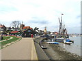
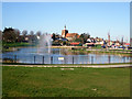
Living in CM9 5FW, a small residential cluster in Essex, offers a blend of historic character and modern convenience. Situated in the town of Maldon, this postcode area sits on the south bank of the Blackwater Estuary, a location with Saxon origins dating back to the 5th century. The area is densely populated, with 1,809 residents spread across 3,393 square metres, creating a compact, tightly knit community. Maldon itself is a historic market town, noted for its medieval architecture and role as a regional trade hub. Daily life here is shaped by its proximity to retail, transport, and cultural landmarks. The area’s small size means residents are close to amenities such as Iceland Maldon, M&S Maldon, and nearby railway stations. With a median age of 47, the community is predominantly composed of adults aged 30–64, many of whom own their homes. The area’s compact nature and historic roots make it appealing for those seeking a mix of tradition and accessibility.
- Area Type
- Postcode
- Area Size
- 3393 m²
- Population
- Not available
- Population Density
- Not available
The property market in CM9 5FW is characterised by a strong presence of owner-occupied homes, with 54% of residents living in properties they own. The accommodation type is predominantly houses, suggesting a market skewed towards single-family homes rather than apartments or flats. This makes the area appealing to buyers seeking traditional housing stock, though the small size of the postcode may limit availability. The high home ownership rate indicates a stable market with long-term residents, but the compact nature of the area means competition for properties could be fierce. For buyers, the focus on houses implies a need to prioritise properties with garden space or larger interiors. The immediate surroundings offer limited scope for new developments, so buyers should consider the local character and proximity to amenities such as retail and rail links when evaluating properties. The market may also reflect the area’s historic appeal, with potential for homes retaining architectural features from Maldon’s Saxon origins.
House Prices in CM9 5FW
No properties found in this postcode.
Energy Efficiency in CM9 5FW
Residents of CM9 5FW have access to a range of amenities within practical reach, enhancing daily life in the area. Nearby retail options include Iceland Maldon, M&S Maldon, and Lidl Heybridge, providing convenience for grocery shopping and everyday needs. The presence of three railway stations—Hatfield Peverel, Witham, and North Fambridge—offers easy access to regional transport, supporting both local and longer-distance travel. The area’s historic character is complemented by cultural landmarks such as St Peter’s Tower, the site of Maldon’s oldest parish church, and All Saints’ Church, which dates back to the 12th century. These sites contribute to a sense of heritage and community identity. The compact nature of the area ensures that amenities are within walking distance for many residents, fostering a lifestyle that balances convenience with the charm of a historic town. The mix of retail, transport, and cultural assets makes CM9 5FW a practical yet characterful place to live.
Amenities
Schools
| Rank | School | Type | Entry gender | Ages |
|---|
Explore more schools in this area
Go to Schools tabDemographics
The community in CM9 5FW is defined by its mature demographic profile, with a median age of 47 and the most common age range being adults aged 30–64. This suggests a population skewed towards middle-aged individuals, likely including families and professionals. Home ownership is relatively high at 54%, indicating a stable residential base, while the remaining 46% are likely renters. The accommodation type is predominantly houses, reflecting a preference for single-family homes over flats or apartments. The predominant ethnic group is White, though specific data on diversity is not provided. The area’s population density of 533,124 people per square kilometre is exceptionally high, which, combined with its small size, implies a tightly packed residential environment. This density may influence local infrastructure and community dynamics, though it does not directly correlate with deprivation levels. For residents, the compact nature of the area ensures proximity to services but may also mean limited space for expansion or new developments.
Household Size
Accommodation Type
Tenure
Ethnic Group
Religion
Household Composition
Age
Household Deprivation
NS-SEC
Explore more demographic insights in this area
Go to Demographics tabPlanning
Planning Constraints
- Flood RiskPremium
- Ramsar Wetland SitesPremium
- Area of Outstanding Natural BeautyPremium
- Protected Nature ReservePremium
- Protected WoodlandPremium