Area Overview for CB9 7LQ
Photos of CB9 7LQ
Area Information
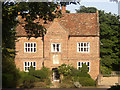
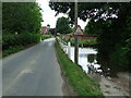
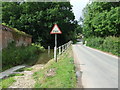
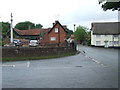
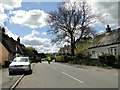
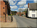
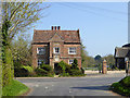
Living in CB9 7LQ means inhabiting a small, rural cluster in Suffolk’s West district, where history and modernity coexist. The area, covering 1,110 square metres, is home to 2,581 people, with a population density of 44 per square kilometre, reflecting its quiet, low-rise character. Great Thurlow, the village associated with this postcode, has roots in the Domesday Book of 1086, once a royal holding with arable land, meadows, and a church. Today, it retains its rural charm but is within practical reach of services in Haverhill, a nearby market town. The area’s small size and modest population density suggest a close-knit community, where daily life is shaped by local traditions and the surrounding countryside. Residents benefit from proximity to historical sites like All Saints Church and Great Thurlow Hall, while the low population density ensures a peaceful, unhurried pace. CB9 7LQ is ideal for those seeking a tranquil, historically rich environment without sacrificing access to essential amenities.
- Area Type
- Postcode
- Area Size
- 1110 m²
- Population
- 2581
- Population Density
- 44 people/km²
The property market in CB9 7LQ is dominated by owner-occupied homes, with 70% of properties owned outright. This contrasts with areas where rental demand drives the market, indicating a community of long-term residents rather than transient tenants. The accommodation type is predominantly houses, which aligns with the rural, low-density nature of the area. This housing stock is likely to appeal to families seeking spacious, traditional homes, though the small size of the postcode means the market is limited in scope. Buyers should consider that the immediate surroundings may offer similar properties, but data on nearby areas is not provided. The high home ownership rate suggests a stable market, but the limited number of properties could mean competition for available homes. For those prioritising family-friendly, low-density living, CB9 7LQ presents a niche opportunity.
House Prices in CB9 7LQ
No properties found in this postcode.
Energy Efficiency in CB9 7LQ
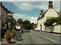
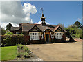
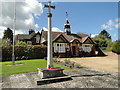
The lifestyle in CB9 7LQ is shaped by its rural setting and proximity to historical and retail amenities. Within practical reach are five retail venues, including Sainsburys Haverhill, Tesco Haverhill, and Spar, offering everyday shopping needs. The area’s historical fabric includes All Saints Church, almshouses founded in 1614, and Great Thurlow Hall, which add cultural and architectural interest. The village’s small size means amenities are concentrated, fostering a sense of community. Residents can enjoy leisure activities at local sites like the Cock Inn, documented since 1674, and the former Congregational Chapel, now a private house. The mix of retail, history, and low-density living creates a lifestyle that balances convenience with tranquillity, ideal for those valuing both modern comforts and heritage.
Amenities
Schools
Residents of CB9 7LQ have access to two schools within practical reach. Thurlow Voluntary Controlled Primary School provides primary education with a good Ofsted rating, ensuring a reliable foundation for younger children. Broadlands Hall, a special school, also holds a good Ofsted rating, offering tailored support for students with specific educational needs. The combination of a primary school and a special school suggests a diverse educational landscape, accommodating both general and specialist requirements. This mix is beneficial for families with children of varying needs, reducing the necessity to travel far for schooling. The quality ratings indicate that both institutions meet or exceed standards, contributing to the area’s appeal for parents seeking reliable education options.
| Rank | School | Type | Entry gender | Ages |
|---|
Explore more schools in this area
Go to Schools tabDemographics
The community in CB9 7LQ is predominantly middle-aged, with a median age of 47 and the most common age range being adults aged 30–64. This suggests a stable, mature population, likely with established careers and families. Home ownership is high at 70%, indicating a strong presence of long-term residents and a market skewed towards owner-occupied properties. The area is characterised by houses rather than flats, reflecting a traditional, family-oriented housing stock. The predominant ethnic group is White, with no data provided on other demographics. The low population density of 44 per square kilometre implies a spread-out, less congested living environment. While no specific deprivation data is available, the high home ownership and age profile suggest a community with relatively stable economic conditions, though this does not preclude individual challenges.
Household Size
Accommodation Type
Tenure
Ethnic Group
Religion
Household Composition
Age
Household Deprivation
NS-SEC
Explore more demographic insights in this area
Go to Demographics tabPlanning
Planning Constraints
- Flood RiskPremium
- Ramsar Wetland SitesPremium
- Area of Outstanding Natural BeautyPremium
- Protected Nature ReservePremium
- Protected WoodlandPremium