Area Overview for CB6 1NU
Photos of CB6 1NU


Area Information
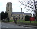
Living in CB6 1NU means inhabiting a small, densely populated residential cluster in East Cambridgeshire, just six miles north of Ely. The area spans 7,981 square metres, housing 1,402 people in a compact layout that reflects its historical roots. Littleport, the village associated with this postcode, sits on the Bedford Level South of the River Great Ouse, near Burnt Fen and Mare Fen. Its past is etched into the landscape: from Domesday Book references to the 1816 riots that destroyed St George’s church records. Today, the area balances heritage with modernity, boasting a Harley-Davidson statue and the Grade II-listed Adams Heritage Centre. Daily life here is shaped by proximity to Ely, with rail links to major towns and a mix of local shops and services. The population density of 175,670 people per square kilometre suggests a tight-knit community, though the small size means residents often know their neighbours. For those seeking a blend of history and practicality, CB6 1NU offers a distinct slice of Cambridgeshire life.
- Area Type
- Postcode
- Area Size
- 7981 m²
- Population
- 1402
- Population Density
- 2628 people/km²
The property market in CB6 1NU is defined by a 57% home ownership rate, suggesting a balance between owner-occupied homes and rental properties. The area is predominantly composed of houses, which aligns with the typical profile of a small rural or semi-rural community. Given the postcode’s size—just 7,981 square metres—and its population of 1,402, the housing stock is likely limited, with properties concentrated in a tight cluster. This scarcity may drive competition among buyers, particularly for family homes. The absence of large-scale development or high-rise housing reinforces a characteristically low-density, residential feel. For prospective buyers, the market offers a chance to own a home in a historically rich area, though the small size means proximity to Ely or other towns may be necessary for additional amenities.
House Prices in CB6 1NU
Showing 9 properties
| Address | Type | Beds | Baths | Last Sale Price | Last Sale Date | |
|---|---|---|---|---|---|---|
| 7 Orchard Close, Littleport, CB6 1NU | Bungalow | 2 | 1 | £232,000 | May 2021 | |
| 4 Orchard Close, Littleport, CB6 1NU | Bungalow | 3 | 1 | £220,000 | Dec 2019 | |
| 8 Orchard Close, Littleport, CB6 1NU | Detached | 2 | 2 | £215,000 | Dec 2014 | |
| 2 Orchard Close, Littleport, CB6 1NU | Bungalow | 2 | - | £130,000 | Jan 2012 | |
| 6 Orchard Close, Littleport, CB6 1NU | Bungalow | 3 | - | £145,000 | Sep 2011 | |
| 5 Orchard Close, Littleport, CB6 1NU | Detached | - | - | £155,000 | Aug 2005 | |
| Lindenlea, 1 Orchard Close, Littleport, CB6 1NU | Bungalow | 3 | 1 | - | - | |
| 3 Orchard Close, Littleport, CB6 1NU | Detached | - | - | - | - | |
| 1A Orchard Close, Littleport, CB6 1NU | Bungalow | - | - | - | - |
Energy Efficiency in CB6 1NU
Residents of CB6 1NU have access to a modest but functional range of amenities. Local retail includes Co-op Main, Co-op Wisbech, and M&S Littleport BP, offering essentials within practical reach. The area’s rail network, with stations at Littleport, Ely, and Shippea Hill, connects to broader regional services, though the village itself lacks large shopping centres or entertainment venues. The proximity to Ely, just six miles away, provides additional options for dining, leisure, and cultural activities. The area’s historical sites, such as the Adams Heritage Centre and the Harley-Davidson statue, add character to daily life. While the immediate vicinity is limited in scale, the compact layout fosters a sense of convenience, with most needs met within walking or short driving distance.
Amenities
Schools
| Rank | School | Type | Entry gender | Ages |
|---|
Explore more schools in this area
Go to Schools tabDemographics
The community in CB6 1NU is predominantly middle-aged, with a median age of 47 and the largest age group being adults aged 30–64. Home ownership sits at 57%, indicating a mix of owner-occupied properties and rentals. The area is characterised by houses rather than flats, reflecting a family-oriented housing stock. The predominant ethnic group is White, though specific data on diversity or deprivation is not provided. The high population density of 175,670 people per square kilometre suggests a compact, possibly multi-generational living environment. With 1,402 residents, the area is small enough for social cohesion but limited in scale for larger amenities. The age profile implies a stable community with established residents, though the absence of data on younger demographics or transient populations means the full picture of social dynamics remains incomplete.
Household Size
Accommodation Type
Tenure
Ethnic Group
Religion
Household Composition
Age
Household Deprivation
NS-SEC
Explore more demographic insights in this area
Go to Demographics tabPlanning
Planning Constraints
- Flood RiskPremium
- Ramsar Wetland SitesPremium
- Area of Outstanding Natural BeautyPremium
- Protected Nature ReservePremium
- Protected WoodlandPremium