Area Overview for CB6 1GD
Photos of CB6 1GD


Area Information
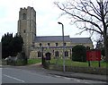
Living in CB6 1GD means being part of a small, tightly knit residential cluster in East Cambridgeshire. This postcode area covers 6,552 m², with a population of 2,286 people spread across 238 residents per km². The area is part of Littleport, a village with historical roots dating back to the Domesday Book, where it was noted for its eel fisheries. Today, CB6 1GD retains a quiet, village character, with a median age of 47 and a population skewed toward adults aged 30–64. The area’s proximity to the River Great Ouse and its connection to historical events like the 1816 riots add depth to its local identity. Residents benefit from nearby rail links, including Littleport and Ely stations, and a mix of retail amenities. The presence of the Harley-Davidson statue and Grade II-listed Adams Heritage Centre highlights a blend of industrial legacy and preserved heritage. For those seeking a low-density, community-focused lifestyle, CB6 1GD offers a balance of historical charm and practical modernity.
- Area Type
- Postcode
- Area Size
- 6552 m²
- Population
- 2286
- Population Density
- 238 people/km²
The property market in CB6 1GD is characterised by high home ownership (73%) and a predominance of houses, with no mention of flats or rental properties. This suggests a largely owner-occupied area, likely with older, established homes given the median age of residents. The small area size of 6,552 m² means the housing stock is limited, potentially making the market competitive for buyers. The proximity to Littleport’s rail stations and retail amenities may enhance property value, though the lack of new developments implies limited scope for expansion. For buyers, this small cluster of homes offers a chance to own in a low-density, historically rich setting. However, the limited size of the area means that immediate surroundings—such as nearby villages like Ely—may be more critical for housing options. The market likely appeals to those prioritising tranquility and historical context over urban convenience.
House Prices in CB6 1GD
Showing 20 properties
| Address | Type | Beds | Baths | Last Sale Price | Last Sale Date | |
|---|---|---|---|---|---|---|
| 9 Guernsey Way, Littleport, CB6 1GD | Terraced | 3 | 2 | £250,000 | Nov 2021 | |
| 16 Guernsey Way, Littleport, CB6 1GD | Terraced | 4 | 2 | £289,950 | Aug 2021 | |
| 8 Guernsey Way, Littleport, CB6 1GD | Semi-detached | 4 | 2 | £260,000 | Apr 2021 | |
| 23 Guernsey Way, Littleport, CB6 1GD | Terraced | 4 | 3 | £270,000 | Sep 2019 | |
| 17 Guernsey Way, Littleport, CB6 1GD | Terraced | 5 | 2 | £300,000 | Dec 2017 | |
| 7 Guernsey Way, Littleport, CB6 1GD | Terraced | - | - | £136,000 | May 2016 | |
| 21 Guernsey Way, Littleport, CB6 1GD | house | - | - | £249,995 | Dec 2015 | |
| 10 Guernsey Way, Littleport, CB6 1GD | Semi-detached | 5 | 2 | £257,000 | Jun 2015 | |
| 19 Guernsey Way, Littleport, CB6 1GD | house | - | - | £238,000 | Apr 2014 | |
| 4 Guernsey Way, Littleport, CB6 1GD | Semi-detached | 3 | 2 | £175,000 | Jan 2014 |
Energy Efficiency in CB6 1GD
Residents of CB6 1GD have access to a modest but functional range of amenities. The area includes five retail venues, such as Co-op Main and M&S Littleport BP, offering everyday shopping needs. Rail stations like Littleport and Ely provide direct links to nearby towns and cities, facilitating travel for work or leisure. The village’s historical sites, including the Harley-Davidson statue and Adams Heritage Centre, add cultural value to daily life. While the area lacks large-scale leisure facilities, its proximity to the River Great Ouse and surrounding countryside offers opportunities for outdoor activities. The mix of retail, transport, and heritage sites creates a lifestyle that balances practicality with a touch of local character. For those valuing convenience without urban sprawl, CB6 1GD provides a compact, accessible environment.
Amenities
Schools
The nearest school to CB6 1GD is Millfield Primary School, which serves the area’s younger residents. The school is listed as a primary institution with an Ofsted rating of ‘good’. This rating indicates a satisfactory standard of education, though no secondary schools are mentioned in the data. The presence of a single primary school suggests that families may need to travel to nearby villages for secondary education. The school’s ‘good’ rating provides reassurance for parents prioritising quality education, but the absence of additional schools means the area is not a hub for multi-academy trusts or larger educational networks. For families relying on local schooling, Millfield Primary School is a key factor in the area’s appeal, though its limited scope may necessitate planning for further schooling options.
| Rank | School | Type | Entry gender | Ages |
|---|
Explore more schools in this area
Go to Schools tabDemographics
The community in CB6 1GD is predominantly composed of adults aged 30–64, with a median age of 47. Home ownership is high at 73%, reflecting a stable, long-term resident population. The area is primarily occupied by houses, with no data on flats or other accommodation types. The predominant ethnic group is White, though no further breakdown of diversity is provided. The population density of 238 people per km² suggests a low-rise, spread-out settlement pattern. This demographic profile indicates a mature, established community with fewer young families or transient populations. The absence of specific data on deprivation or socioeconomic diversity means the area’s quality of life is inferred from its safety, connectivity, and amenities. The high home ownership rate and age distribution suggest a focus on comfort and stability over rapid growth or development.
Household Size
Accommodation Type
Tenure
Ethnic Group
Religion
Household Composition
Age
Household Deprivation
NS-SEC
Explore more demographic insights in this area
Go to Demographics tabPlanning
Planning Constraints
- Flood RiskPremium
- Ramsar Wetland SitesPremium
- Area of Outstanding Natural BeautyPremium
- Protected Nature ReservePremium
- Protected WoodlandPremium