Area Overview for CB22 4QX
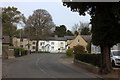
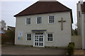
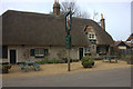
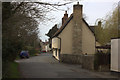
Photos of CB22 4QX
Area Information
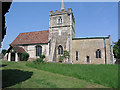
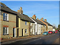
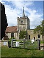
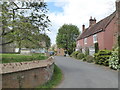
Living in CB22 4QX means being part of a small, tightly knit residential cluster in the heart of Duxford, Cambridgeshire. This area covers 33.9 hectares and is home to 1,505 residents, creating a population density of 602 people per square kilometre. The community reflects a blend of rural heritage and modern suburban convenience, with a commuter village character shaped by its proximity to Cambridge and surrounding towns. Duxford’s history as a Royal Air Force base and its transformation into a hub for the Imperial War Museum add a unique layer to daily life. Residents benefit from a mix of historical landmarks, such as St. Peter’s Church and the Duxford Aerodrome, alongside contemporary amenities like a community centre and local shops. The area’s compact size means most services are within practical reach, while its location offers easy access to rail networks and nearby towns. For those seeking a balance between tradition and modernity, CB22 4QX provides a distinct identity rooted in both agricultural past and evolving infrastructure.
- Area Type
- Postcode
- Area Size
- 33.9 hectares
- Population
- 1505
- Population Density
- 602 people/km²
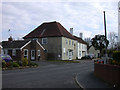
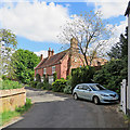
The property market in CB22 4QX is characterised by a high rate of home ownership, with 73% of residents occupying their own homes. This suggests a stable, long-term resident base rather than a rental market. The predominant accommodation type is houses, which is typical for rural and semi-rural areas with limited high-density development. Given the area’s small size—33.9 hectares—and its status as a commuter village, the housing stock is likely to be limited in both quantity and diversity. Buyers considering this area should expect a focus on family homes, with limited availability of newer properties or flats. The compact nature of the postcode means that property values may be influenced by proximity to key amenities such as the Imperial War Museum and local schools. For those seeking a quiet, established residential area with a strong sense of community, CB22 4QX offers a niche market with clear priorities for homeownership and traditional housing.
House Prices in CB22 4QX
No properties found in this postcode.
Energy Efficiency in CB22 4QX
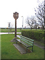
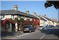
The lifestyle in CB22 4QX is shaped by a mix of historical landmarks, local amenities, and community-focused spaces. The Imperial War Museum Duxford, housed on the former RAF airfield, is a major draw, offering both educational and recreational opportunities. Nearby, St. Peter’s Church and Duxford Chapel provide cultural and spiritual anchors, while the village’s community centre, opened in 2020, offers a hub for social activities, including a café and parking. Local pubs such as the Plough and the John Barleycorn, along with a deli and café, contribute to a vibrant, small-town atmosphere. Retail options like M&S and Co-op cater to daily needs, and the proximity to rail stations ensures easy access to larger towns. This blend of heritage, convenience, and community facilities creates a lifestyle that is both rooted in tradition and adaptable to modern living.
Amenities
Schools
The primary school nearest to CB22 4QX is Duxford Church of England Community Primary School, which serves the local area with an Ofsted rating of ‘good’. This school is a key asset for families with young children, offering a foundation for early education within walking distance of many homes. The absence of secondary schools in the immediate vicinity means that students will need to commute to nearby towns for further education, but the primary school’s quality rating suggests a strong start to academic life. The presence of a single primary school also indicates that the area’s population is largely composed of families with younger children, reinforcing the community’s demographic profile. For prospective buyers, the availability of a well-rated primary school is a significant factor in assessing the suitability of CB22 4QX for family-oriented living.
| Rank | School | Type | Entry gender | Ages |
|---|
Explore more schools in this area
Go to Schools tabDemographics
The demographic profile of CB22 4QX is defined by a median age of 47, with the majority of residents falling within the 30–64 age range. This suggests a community of established adults, many of whom are likely to be homeowners, as 73% of properties are owner-occupied. The predominant accommodation type is houses, reflecting a residential area focused on family homes rather than flats or apartments. The predominant ethnic group is White, aligning with broader trends in rural Cambridgeshire. The age distribution indicates a mature population, which may influence local services and amenities. With 1,505 residents spread across 1,124 households, the area maintains a relatively low population density, contributing to a quieter, more private living environment. This demographic structure suggests a community where stability and long-term residency are common, with limited presence of younger families or transient populations.
Household Size
Accommodation Type
Tenure
Ethnic Group
Religion
Household Composition
Age
Household Deprivation
NS-SEC
Explore more demographic insights in this area
Go to Demographics tabPlanning
Planning Constraints
- Flood RiskPremium
- Ramsar Wetland SitesPremium
- Area of Outstanding Natural BeautyPremium
- Protected Nature ReservePremium
- Protected WoodlandPremium