Area Overview for CB22 4LX
Photos of CB22 4LX
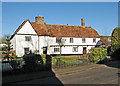
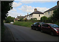
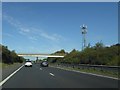
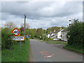
53 photos from this area
Area Information
Key information about the CB22 4LX including its size, population, and administrative classification.
- Area Type
- Postcode
- Area Size
- 18.2 hectares
- Population
- 1237
- Population Density
- 396 people/km²
House Prices in CB22 4LX
55
Properties
£458,986
Average Sold Price
£114,000
Lowest Price
£1,000,000
Highest Price
Showing 55 properties
| Address | Type | Beds | Baths | Last Sale Price | Last Sale Date | |
|---|---|---|---|---|---|---|
| 47 West End, Whittlesford, CB22 4LX | Semi-detached | 4 | 2 | £600,000 | Nov 2024 | |
| 23 West End, Whittlesford, CB22 4LX | house | - | - | £975,000 | Aug 2024 | |
| 56 West End, Whittlesford, CB22 4LX | Semi-detached | 2 | 1 | £275,000 | May 2024 | |
| 45 West End, Whittlesford, CB22 4LX | house | - | - | £650,000 | Sep 2021 | |
| 35 West End, Whittlesford, CB22 4LX | Detached | 2 | 1 | £355,000 | Feb 2020 | |
| 2 West End, Whittlesford, CB22 4LX | house | - | - | £400,000 | Dec 2019 | |
| Parsonage Corner, West End, Whittlesford, CB22 4LX | house | - | - | £708,600 | Dec 2019 | |
| 28 West End, Whittlesford, CB22 4LX | Detached | 5 | 2 | £545,000 | Nov 2018 | |
| Rhossili, 29 West End, Whittlesford, CB22 4LX | Detached | 4 | - | £685,000 | Aug 2018 | |
| 10 West End, Whittlesford, CB22 4LX | Detached | 5 | 2 | £1,000,000 | Apr 2018 |
Page 1 of 6
Energy Efficiency in CB22 4LX
Amenities
Schools
| Rank | School | Type | Entry gender | Ages |
|---|
Explore more schools in this area
Go to Schools tabDemographics
Household Size
Two person
most common
Accommodation Type
Houses
most common
Tenure
73
majority
Ethnic Group
White
most common
Religion
N/A
most common
Household Composition
N/A
most common
Age
47
median
Adults (30-64 years)
most common
Household Deprivation
N/A
with no deprivation
NS-SEC
54
in Lower managerial occupations
Explore more demographic insights in this area
Go to Demographics tabPlanning
Planning Constraints
- Flood RiskPremium
- Ramsar Wetland SitesPremium
- Area of Outstanding Natural BeautyPremium
- Protected Nature ReservePremium
- Protected WoodlandPremium