Area Overview for NN3 8HH
Photos of NN3 8HH


Area Information
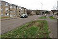
Living in NN3 8HH means inhabiting a compact, densely populated residential cluster in England. The area covers just 1.3 hectares, yet it accommodates 1,801 residents, translating to a population density of 135,755 people per square kilometre. This suggests a tight-knit, possibly urbanised environment, though the exact nature of the layout is not specified. The area’s proximity to Northampton Railway Station and multiple bus interchanges, including the University Bus Interchange, offers convenient transport links. Daily life here is shaped by its small size and the presence of nearby retail outlets such as Tesco Northampton and Lidl Lings. The median age of 47 indicates a community skewed towards adults, with the 30–64 age range being the most common. This suggests a mix of established residents and professionals, though the low home ownership rate of 34% implies a higher proportion of renters. The broadband score of 99 ensures excellent connectivity, supporting remote work or online activities, while mobile coverage is good but not exceptional.
- Area Type
- Postcode
- Area Size
- 1.3 hectares
- Population
- 1801
- Population Density
- 4161 people/km²
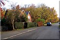
The property market in NN3 8HH is characterised by a low home ownership rate of 34%, suggesting that the majority of residents are renters rather than homeowners. This may indicate a transient population or a focus on rental properties in the area. The accommodation type is predominantly houses, which is unusual for a small, high-density postcode. This could mean the area includes semi-detached or terraced homes, though the exact types are not specified. For buyers, the limited size of the area—just 1.3 hectares—means competition for properties is likely to be high. The proximity to Northampton Railway Station and multiple bus routes may appeal to those prioritising transport links over expansive living spaces. However, the high population density and small footprint suggest that property availability is constrained, and buyers should consider the area’s compact nature when evaluating options.
House Prices in NN3 8HH
Showing 40 properties
| Address | Type | Beds | Baths | Last Sale Price | Last Sale Date | |
|---|---|---|---|---|---|---|
| 21 Bitten Court, Northampton, NN3 8HH | house | - | - | £160,000 | Oct 2020 | |
| 25 Bitten Court, Northampton, NN3 8HH | Terraced | 3 | 1 | £165,000 | Sep 2020 | |
| 20 Bitten Court, Northampton, NN3 8HH | Terraced | 3 | 1 | £175,000 | Aug 2020 | |
| 29 Bitten Court, Northampton, NN3 8HH | house | - | - | £90,000 | Apr 2020 | |
| 33 Bitten Court, Northampton, NN3 8HH | Terraced | 3 | 1 | £146,000 | Nov 2019 | |
| 4 Bitten Court, Northampton, NN3 8HH | Terraced | 3 | 1 | £169,995 | Nov 2017 | |
| 15 Bitten Court, Northampton, NN3 8HH | Terraced | 5 | 2 | £156,000 | Aug 2017 | |
| 26 Bitten Court, Northampton, NN3 8HH | house | 3 | 1 | £133,000 | Mar 2016 | |
| 12 Bitten Court, Northampton, NN3 8HH | house | - | - | £129,995 | Mar 2016 | |
| 28 Bitten Court, Northampton, NN3 8HH | Flat | 1 | 2 | £105,000 | Jan 2008 |
Energy Efficiency in NN3 8HH
Residents of NN3 8HH have access to a range of nearby amenities within practical reach. Retail options include major supermarkets such as Tesco Northampton, Lidl Lings, and Co-op Bushland, ensuring everyday shopping needs are met without long journeys. The area’s transport links, including the University Bus Interchange and Northampton Railway Station, provide easy access to broader networks, supporting both work and leisure activities. While specific parks or leisure facilities are not mentioned, the proximity to Northampton—a city with cultural and recreational offerings—suggests additional opportunities beyond the immediate postcode. The presence of multiple bus routes and a railway station enhances the area’s convenience, making it feasible to explore nearby attractions or commute to larger urban centres. The compact nature of NN3 8HH means daily life is centred around its immediate surroundings, with a focus on accessibility over expansive green spaces.
Amenities
Schools
| Rank | School | Type | Entry gender | Ages |
|---|
Explore more schools in this area
Go to Schools tabDemographics
The community in NN3 8HH is predominantly composed of adults aged 30–64, with a median age of 47. This suggests a mature population, likely with established careers and families. Home ownership is low, with only 34% of residents owning their homes, indicating a rental market that may cater to younger professionals or those seeking flexibility. The accommodation type is primarily houses, which is uncommon in densely populated areas, suggesting a mix of semi-detached or terraced properties. The predominant ethnic group is White, though no specific data on diversity or deprivation levels is provided. The high population density of 135,755 people per square kilometre implies limited private space, which could influence lifestyle choices. For those prioritising proximity to amenities over space, the area’s compact nature may be an advantage, though it could also contribute to a sense of overcrowding.
Household Size
Accommodation Type
Tenure
Ethnic Group
Religion
Household Composition
Age
Household Deprivation
NS-SEC
Explore more demographic insights in this area
Go to Demographics tabPlanning
Planning Constraints
- Flood RiskPremium
- Ramsar Wetland SitesPremium
- Area of Outstanding Natural BeautyPremium
- Protected Nature ReservePremium
- Protected WoodlandPremium