Area Overview for NN18 0QF
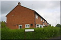
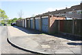
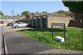
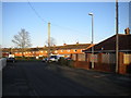
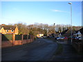
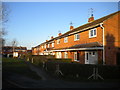
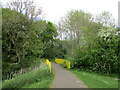
Photos of NN18 0QF


Area Information
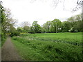
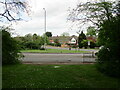
NN18 0QF is a small residential cluster in Corby, Northamptonshire, covering just 4.6 hectares. With a population of 1,589 and a density of 34,317 people per square kilometre, this area is compact and tightly knit. Corby itself is a town with a history rooted in industry, designated a new town in 1950 to accommodate the growth of its steelworks. Today, NN18 0QF reflects a mix of older and newer housing, shaped by the town’s industrial past. The area is close to essential amenities, including retail stores, a railway station, and bus routes, making daily life practical for residents. The median age of 47 suggests a community of established adults, many of whom are likely long-term residents. While the area lacks large green spaces or natural landmarks, its proximity to Corby’s core infrastructure means residents benefit from the town’s services without the congestion of larger urban centres. For buyers, NN18 0QF offers a blend of affordability and accessibility, though the high population density means properties are limited in number and often sought after.
- Area Type
- Postcode
- Area Size
- 4.6 hectares
- Population
- 1589
- Population Density
- 6261 people/km²
The property market in NN18 0QF is characterised by a low home ownership rate of 36%, suggesting a rental market dominates. The accommodation type is primarily houses, which may indicate a mix of older, family-oriented homes and newer builds. Given the area’s small size, the housing stock is likely limited, with properties competing for attention among buyers and renters. The compact nature of NN18 0QF means that homes are closely spaced, which may appeal to those seeking affordability and proximity to Corby’s amenities. However, the high population density could limit scope for larger properties or developments. Buyers should consider the area’s industrial heritage, which may influence property aesthetics or location near former steelworks. While the market is not expansive, the availability of houses suggests a niche for those prioritising single-family living over apartments or terraced homes.
House Prices in NN18 0QF
No properties found in this postcode.
Energy Efficiency in NN18 0QF
Residents of NN18 0QF have access to a range of nearby amenities, including retail stores such as Morrisons Daily Corby, Iceland Corby, and Lidl Central. These shops provide essential groceries and household items, reducing the need for long trips. The Corby Railway Station and bus interchange offer easy access to broader transport networks, enabling travel to nearby towns and cities. While the area lacks large parks or leisure facilities, its proximity to Corby’s core means residents can enjoy the town’s amenities, including cultural venues and dining options. The compact layout of NN18 0QF ensures that daily errands are efficient, though the lack of green spaces may be a drawback for those prioritising outdoor recreation. The presence of retail and transport hubs suggests a practical, service-oriented lifestyle, ideal for those valuing convenience over expansive natural environments.
Amenities
Schools
Near NN18 0QF are Hazel Leys Infant School, a primary school, and Maplefields School, a special school. Hazel Leys serves younger children, while Maplefields caters to students with specific educational needs. The presence of both school types offers families flexibility, though the absence of secondary schools nearby may require travel. The mix indicates a focus on early education and specialist support, which could be advantageous for families with children requiring tailored learning environments. However, the lack of data on Ofsted ratings means the quality of these institutions remains unclear. Parents should consider whether the schools meet their child’s needs, particularly if secondary education is not available locally. The proximity of these schools to the area underscores Corby’s role as a service hub for surrounding communities.
| Rank | School | Type | Entry gender | Ages |
|---|---|---|---|---|
| 1 | Hazel Leys Infant School | primary | N/A | N/A |
| 2 | Maplefields School | special | N/A | N/A |
Explore more schools in this area
Go to Schools tabDemographics
The community in NN18 0QF is predominantly composed of adults aged 30–64, with a median age of 47. This suggests a mature population, likely with established careers and families. Home ownership here is relatively low at 36%, indicating that a significant portion of the housing stock is rented. The accommodation type is primarily houses, which may reflect a preference for single-family dwellings in this compact area. The predominant ethnic group is White, with no specific data provided on other demographics. The high population density of 34,317 people per square kilometre implies a tightly packed residential environment, which could influence the availability of private outdoor space. For buyers, this density may mean limited land for expansion, but it also ensures proximity to local services. The absence of detailed diversity data means the community’s full composition remains less defined, though the age profile suggests a stable, middle-aged population.
Household Size
Accommodation Type
Tenure
Ethnic Group
Religion
Household Composition
Age
Household Deprivation
NS-SEC
Explore more demographic insights in this area
Go to Demographics tabPlanning
Planning Constraints
- Flood RiskPremium
- Ramsar Wetland SitesPremium
- Area of Outstanding Natural BeautyPremium
- Protected Nature ReservePremium
- Protected WoodlandPremium
- Crime RiskPremium