Area Overview for NG9 2FF
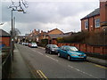
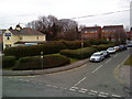
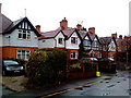
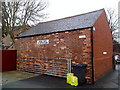
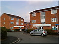
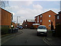
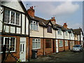
Photos of NG9 2FF

Area Information
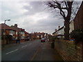
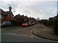
Living in NG9 2FF means residing within a highly compact residential cluster that spans just 5779 square metres. This specific postcode covers a small pocket of England where 1652 people make their homes. The density here is extremely high, with approximately 285,879 people per square kilometre according to the recorded metrics. Such figures indicate a tightly packed environment where neighbours are within short walking distances. Daily life in NG9 2FF is defined by immediate proximity to major transport hubs and shopping centres. You have direct access to the tram and bus interchange at Middle Street, alongside the Beeston Centre Tram Stop. Retail options include Tesco Nottingham, Co-op Queens, and Sainsburys Beeston, all located within practical reach. Your commute is simplified by the presence of Beeston Railway Station, Attenborough Railway Station, and Nottingham Railway Station nearby. Nottingham Airport is also accessible from this location. While the area functions as a straightforward residential utility, the sheer concentration of occupants in a small space creates a distinctively intense living environment. There is no room for sprawl here; everything is concentrated. This clustering means that noise levels and street activity will be higher than in sprawling suburbs. The community is practical and utilitarian, prioritising functional access over spacious gardens. You will find yourself part of a dense urbanised zone where convenience dictates the layout of every street block.
- Area Type
- Postcode
- Area Size
- 5779 m²
- Population
- 1652
- Population Density
- 7075 people/km²
The property market in NG9 2FF is characterised by a stock dominated by houses. Catalogue data identifies houses as the primary accommodation type, distinguishing this postcode from areas built mainly of flats or terraced rows. This housing style suits the resident demographic, who clusters around the 30 to 64-year-old age bracket. Despite the dominance of houses, only 42 per cent of households report home ownership. This means that 58 per cent of residents live in rented properties or shared ownership schemes. The imbalance suggests a rental market coexists with owner-occupiers, though the available data does not specify the exact split between private and social renting. Prospective buyers should note that this is a small, specific cluster rather than a sprawling district with varied price points. The high population density of 285,879 people per square kilometre compresses the available housing stock into a very limited space. You are looking at a market where property values may be constrained by land availability. The presence of medium crime risk and flood risk considerations could impact resale values for future owners. Properties here offer immediate access to transport links, which maintains demand but does not necessarily inflate prices to extraordinary levels. The mix of owner and renter households suggests a diverse market where competition for homes is balanced against rental availability. Buyers must act quickly if they find a suitable house, given the dense competition for space in this small postcode area.
House Prices in NG9 2FF
Showing 21 properties
| Address | Type | Beds | Baths | Last Sale Price | Last Sale Date | |
|---|---|---|---|---|---|---|
| 180 Queens Road, Beeston, NG9 2FF | Unknown | - | - | £182,500 | Feb 2023 | |
| 150 Queens Road, Beeston, NG9 2FF | Semi-detached | 6 | 5 | £210,000 | Oct 2020 | |
| 148 Queens Road, Beeston, NG9 2FF | Semi-detached | 3 | 1 | £229,250 | Dec 2018 | |
| 174 Queens Road, Beeston, NG9 2FF | Terraced | 4 | 1 | £150,000 | Jan 2018 | |
| 172 Queens Road, Beeston, NG9 2FF | Terraced | 3 | 1 | £109,000 | Apr 2012 | |
| 176 Queens Road, Beeston, NG9 2FF | house | - | - | £102,000 | Apr 2008 | |
| Commerce House, 168 Queens Road, Beeston, NG9 2FF | Terraced | 7 | 4 | £134,000 | Jun 2007 | |
| 170 Queens Road, Beeston, NG9 2FF | Terraced | 3 | - | £127,500 | Dec 2006 | |
| 146 Queens Road, Beeston, NG9 2FF | Semi-detached | - | - | £160,000 | Jun 2005 | |
| 140B Queens Road, Beeston, NG9 2FF | Terraced | 4 | 1 | £150,000 | Mar 2002 |
Energy Efficiency in NG9 2FF
Amenities
Schools
Families living in NG9 2FF have access to John Clifford Primary School, which is situated within practical reach of the residential cluster. This institution operates as a primary school and holds an Ofsted rating of good. The rating confirms that the school meets consistent standards of quality and educational provision for local children. No secondary schools are listed in the immediate data for this specific postcode, meaning primary education is the key nearby facility. The mix of school types currently available focuses on early years foundation and lower school education. Parents moving into NG9 2FF with young children can rely on a single, well-rated option for their children's early schooling. The school's good rating provides reassurance regarding the educational environment your child would experience. Beyond academic ratings, the location of John Clifford Primary School integrates well with the community's demographic profile of adults in their 30s and 40s. You do not have to travel far to ensure your child's education needs are met within the wake of their daily routine. The absence of nearby secondary data suggests that older children may need to travel further for comprehensive or grammar education. However, the primary provision is solid. The school serves the direct neighbourhood, avoiding long bus journeys for younger pupils. This proximity reduces daily stress and maximises time spent on homework or extracurricular activities at home. For those prioritising education quality and location, this single school represents the core educational heritage of NG9 2FF.
| Rank | School | Type | Entry gender | Ages |
|---|
Explore more schools in this area
Go to Schools tabDemographics
The community in NG9 2FF is defined by an established age profile. The median age stands at 47 years, indicating that the resident population is significantly older than the national average. The most common age range is adults between 30 and 64 years, suggesting the area attracts families and professionals in their prime working years. This demographic skew likely influences the demand for larger properties and stable neighbourhoods. Home ownership accounts for 42 per cent of all households in NG9 2FF. This figure represents a balanced mix of leaseholders and freeholders, rather than a market dominated by landlords or owner-occupiers. The predominant form of accommodation consists of houses, which aligns with the age profile of the residents. White residents make up the predominant ethnic group within this postcode, reflecting broader trends in the surrounding Midlands region. You can expect a homogenous population that has settled in this location for the long term. The lack of significant youth cohorts implies fewer noisy evenings and a quieter street atmosphere on weekends. With almost half of the population owning their homes, residents tend to be more invested in long-term improvements to their properties. This stability contributes to a predictable community dynamic where neighbours look out for one another. The population density of nearly 300,000 people per square kilometre further reinforces the tight-knit nature of this specific residential cluster.
Household Size
Accommodation Type
Tenure
Ethnic Group
Religion
Household Composition
Age
Household Deprivation
NS-SEC
Explore more demographic insights in this area
Go to Demographics tabPlanning
Planning Constraints
- Flood RiskPremium
- Ramsar Wetland SitesPremium
- Area of Outstanding Natural BeautyPremium
- Protected Nature ReservePremium
- Protected WoodlandPremium