Area Overview for NG17 1AN
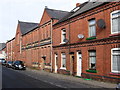
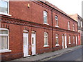
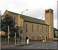
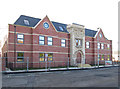
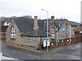
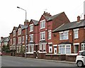
Photos of NG17 1AN


Area Information
Living in NG17 1AN means inhabiting a tightly packed residential cluster in England’s East Midlands, where 1,195 people reside across just 3,966 square metres. This results in a population density of 301,302 people per square kilometre, one of the highest in the country. The area’s compact size and high density define its character — it is not a sprawling suburb but a closely knit community. Daily life here is shaped by proximity, with homes, amenities, and transport nodes all within walking or short driving distance. The area’s small footprint means it is not suited to those seeking expansive spaces, but it offers a sense of immediacy: shops, schools, and transport links are all within practical reach. NG17 1AN is a place where convenience trumps scale, and its residents are likely to be familiar with their neighbours. The area’s demographic profile — predominantly adults aged 30–64 — suggests a community of long-term residents, many of whom may have lived here for decades. For those considering a move, NG17 1AN is a compact, high-density option with a clear identity.
- Area Type
- Postcode
- Area Size
- 3966 m²
- Population
- 1195
- Population Density
- 3304 people/km²
The property market in NG17 1AN is characterised by a low home ownership rate of 38%, which is significantly below the national average. This suggests that the area is more reliant on rental properties than owner-occupied homes, possibly due to its high density and compact size. The accommodation type is predominantly houses, which is an unusual feature for a small, densely populated area. This mix of house types may indicate a blend of older, larger properties and newer developments, though the exact age of the housing stock is not specified. For buyers, this small area presents a limited pool of properties, with most options likely to be in the rental market. The high density also means that properties are closely spaced, which could be a consideration for those seeking private outdoor space. Given the area’s size, buyers should focus on immediate surroundings to find a broader range of options, though the market is likely to be competitive due to the area’s constrained footprint.
House Prices in NG17 1AN
Showing 9 properties
Energy Efficiency in NG17 1AN
Residents of NG17 1AN have access to a range of nearby amenities, including five retail outlets such as Asda Sutton, Iceland Sutton, and Heron Carsic Estate Sutton in. These shops provide essential services, from groceries to general retail, supporting daily life in the area. The rail network is also well-connected, with five stations nearby, including Sutton Parkway Railway Station and Kirkby in Ashfield Railway Station, offering regular links to larger towns and cities. While the area’s compact size means there are no large parks or leisure facilities within the postcode itself, the proximity to rail stations and retail hubs suggests that residents can easily access broader amenities in surrounding areas. The presence of multiple retail options and transport links contributes to a functional lifestyle, where convenience and accessibility are prioritised. For those who enjoy a mix of practicality and connectivity, NG17 1AN offers a base that allows easy access to both local services and regional opportunities.
Amenities
Schools
| Rank | School | Type | Entry gender | Ages |
|---|
Explore more schools in this area
Go to Schools tabDemographics
The community in NG17 1AN is predominantly composed of adults aged 30–64, with a median age of 47. This suggests a mature population, likely with established careers and family ties to the area. Home ownership here is relatively low at 38%, indicating that a significant portion of residents are likely to be renters, possibly in private or social housing. The accommodation type is primarily houses, which is unusual for such a high-density area, hinting at a mix of older, larger properties and newer developments. The predominant ethnic group is White, with no specific data provided on other ethnicities. The high population density, combined with the age profile, suggests a community that may be less transient than average, with residents potentially prioritising proximity to services over space. The lack of detailed diversity data means the area’s cultural makeup remains less defined, but the demographic profile points to a stable, middle-aged population with a focus on practical living.
Household Size
Accommodation Type
Tenure
Ethnic Group
Religion
Household Composition
Age
Household Deprivation
NS-SEC
Explore more demographic insights in this area
Go to Demographics tabPlanning
Planning Constraints
- Flood RiskPremium
- Ramsar Wetland SitesPremium
- Area of Outstanding Natural BeautyPremium
- Protected Nature ReservePremium
- Protected WoodlandPremium