Area Overview for NG16 6HL
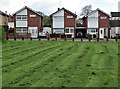
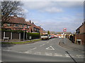
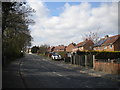
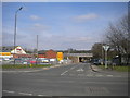
Photos of NG16 6HL


Area Information
NG16 6HL is a small, tightly packed residential area in England, spanning just 7.3 hectares and home to 1,492 people. Its compact size means it feels like a close-knit community, where daily life is shaped by proximity to local amenities and natural surroundings. The area’s population density of 765 people per square kilometre reflects its residential focus, with a median age of 47 and a majority of residents aged 30–64. This suggests a stable, mature demographic, likely drawn to the area for its quiet, family-friendly environment. The postcode sits near Pinxton, a village with a mix of traditional and modern living. Residents benefit from nearby schools, rail links, and retail hubs, making it practical for families and commuters. While the area lacks large-scale infrastructure, its small footprint ensures a sense of intimacy, with homes and services clustered closely. For those seeking a balance between rural charm and accessible amenities, NG16 6HL offers a snapshot of English village life, tempered by modern connectivity.
- Area Type
- Postcode
- Area Size
- 7.3 hectares
- Population
- 1492
- Population Density
- 765 people/km²
The property market in NG16 6HL is characterised by a 55% home ownership rate, with houses forming the majority of accommodation types. This suggests a predominantly owner-occupied area, though the relatively small size of the postcode means the housing stock is limited. The focus on houses rather than flats or apartments indicates a traditional, low-density development pattern, likely appealing to those seeking private outdoor space. For buyers, the area’s compact nature means properties are closely spaced, with limited scope for expansion. The proximity to nearby towns like Pinxton and accessible rail links may make it attractive to commuters, though the small size of NG16 6HL itself means buyers should consider nearby areas for additional options. The market is likely stable, with homes catering to families and professionals seeking a quieter lifestyle.
House Prices in NG16 6HL
Showing 28 properties
| Address | Type | Beds | Baths | Last Sale Price | Last Sale Date | |
|---|---|---|---|---|---|---|
| 24A Town Street, Pinxton, NG16 6HL | Detached | 4 | 1 | £245,000 | Mar 2024 | |
| 34 Town Street, Pinxton, NG16 6HL | house | 3 | 1 | £262,000 | Jan 2024 | |
| 10 Town Street, Pinxton, NG16 6HL | Detached | 2 | - | £186,500 | Dec 2020 | |
| 34A Town Street, Pinxton, NG16 6HL | Bungalow | 2 | 1 | £180,000 | Oct 2018 | |
| 16 Town Street, Pinxton, NG16 6HL | Detached | 3 | 1 | £145,000 | May 2017 | |
| 36 Town Street, Pinxton, NG16 6HL | Detached | 3 | - | £180,000 | Mar 2016 | |
| 18 Town Street, Pinxton, NG16 6HL | house | - | - | £89,950 | Nov 2011 | |
| 26 Town Street, Pinxton, NG16 6HL | house | 5 | - | £153,000 | Jul 2011 | |
| 22 Town Street, Pinxton, NG16 6HL | house | - | - | £108,000 | Jan 2007 | |
| 20 Town Street, Pinxton, NG16 6HL | Semi-detached | - | - | £105,000 | Jan 2006 |
Energy Efficiency in NG16 6HL
The lifestyle in NG16 6HL is shaped by its proximity to retail and transport hubs. Residents have access to five retail venues, including Co-op Pinxton, M&S Mansfield, and Spar, offering everyday shopping needs. The nearby rail stations also act as social and commercial centres, connecting the area to broader networks. While the postcode itself is small, the surrounding region provides additional leisure and dining options. The compact nature of the area means amenities are within walking or short driving distance, fostering a convenient, community-oriented lifestyle. Though the data does not specify parks or recreational facilities, the presence of schools and retail suggests a balanced approach to daily living, prioritising practicality and accessibility.
Amenities
Schools
Residents of NG16 6HL have access to a range of educational institutions within practical reach. The area is served by Pinxton Nursery School, which provides early-years education, and Pinxton Kirkstead Junior School, a primary school catering to younger children. For older students, Kirkstead Junior Academy offers a good Ofsted-rated education, indicating a strong academic environment. The mix of nursery, primary, and academy schools ensures a seamless transition for families throughout a child’s education. The presence of a rated academy suggests a commitment to quality teaching, which is a significant draw for families prioritising educational standards. With three schools within proximity, the area supports both casual and formal learning needs, making it a viable option for households with children.
| Rank | School | Type | Entry gender | Ages |
|---|
Explore more schools in this area
Go to Schools tabDemographics
The community in NG16 6HL is predominantly composed of adults aged 30–64, with a median age of 47. This suggests a population that is largely settled, with fewer young families or retirees compared to other areas. Home ownership sits at 55%, indicating a mix of owner-occupied properties and rental homes. The accommodation type is primarily houses, reflecting a traditional, low-density housing stock. The predominant ethnic group is White, with no data provided on other demographics. The population density of 765 people per square kilometre, while high for such a small area, points to a compact, efficient layout. This density may influence local services, such as schools and retail, which are designed to meet the needs of a relatively small but active population. The absence of specific deprivation data means it is unclear how economic factors might affect quality of life, though the presence of nearby amenities suggests a reasonable standard of living.
Household Size
Accommodation Type
Tenure
Ethnic Group
Religion
Household Composition
Age
Household Deprivation
NS-SEC
Explore more demographic insights in this area
Go to Demographics tabPlanning
Planning Constraints
- Flood RiskPremium
- Ramsar Wetland SitesPremium
- Area of Outstanding Natural BeautyPremium
- Protected Nature ReservePremium
- Protected WoodlandPremium