Area Overview for Brymbo Community
Photos of Brymbo Community

Area Information
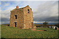
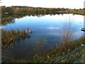
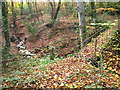
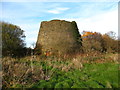
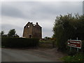
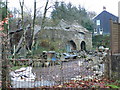
Living in Brymbo Community offers a rooted experience within a civil parish that spans 10.3 km² across Wrexham County Borough. The area encompasses several distinct settlements, including the village of Brymbo, Tanyfron, Bwlchgwyn, and Vron. Surrounding hamlets such as Pen-Rhos, Four Crosses, Maes Maelor, Glascoed, and Ffrwd share the parish boundaries under the governance of the Brymbo Community Council. You will find the village constructed on the steep sides of Brymbo Hill, providing views towards the Cheshire Plain. The location carries deep historical weight; the name possibly derives from the Welsh *Bryn baw*, meaning "mud hill", with records appearing as early as 1339. Industrial activity shaped the landscape when the Brymbo Steelworks operated from 1794 until its closure in 1990. Today, the former steelworks site hosts Stori Brymbo, a heritage centre that serves as a focal point for the community. Archaeological significance remains present through Brymbo Man, a Bronze Age skeleton dating to approximately 1600 BC which is displayed in the Wrexham County Borough Museum. Residents navigate a terrain defined by this industrial and agricultural past. Whether you are considering homes in Brymbo or exploring the wider parish, the setting combines historical depth with the practicalities of rural North Wales living. The three electoral wards of Brymbo, Bwlchgwyn, and Vron structure local representation and administrative affairs.
- Area Type
- Parish
- Area Size
- 10.3 km²
- Population
- Not available
- Population Density
- Not available
Demographics
The population profile of Brymbo Community reflects a mature demographic, with a median age of 70 years. This figure indicates that the majority of residents are seniors rather than young families or working-age individuals. While the provided data does not separate the Age category into specific ranges, the overall median confirms an older settlement structure. Home ownership stands at 68% of households, suggesting a high level of local stability and long-term residency. Most people in the area own their homes outright rather than renting, which aligns with the older median age profile. The community does not contain significant protected nature reserves or Ramsar wetland sites, ensuring that land use planning focuses on other environmental constraints. Specifically, the parish contains protected woodland, which acts as a planning constraint for future development. You should note that crime risk data is currently only available for areas in England, so specific local crime statistics are not provided in the dataset. Religion and predominant ethnic group details are listed as total in the data, meaning specific breakdowns by faith or ethnicity are not available for this parish. When evaluating living in Brymbo, understand that the community is dominated by older homeowners rather than a mixed-age rental population.
Household Size
Accommodation Type
Tenure
Ethnic Group
Religion
Household Composition
Age
Household Deprivation
NS-SEC
Explore more demographic insights in this area
Go to Demographics tabPlanning
Planning Constraints
- Flood RiskPremium
- Ramsar Wetland SitesPremium
- Protected Nature ReservePremium
- Protected WoodlandPremium
- Crime RiskPremium