Area Overview for Sully and Lavernock Community
Photos of Sully and Lavernock Community


Area Information
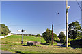
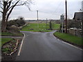
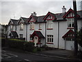
Sully and Lavernock Community is a civil parish covering 8.4 km² in the Vale of Glamorgan, Wales. This area forms a residential parish that serves as a coastal Sleeping community for commuters heading to Cardiff. You will find the main settlement in Sully village, alongside the coastal hamlets of Swanbridge and Lavernock. The parish includes the Cosmeston area, creating a distinct mix of village life and seaside location. Residents live approximately 6 miles southwest of Cardiff, with the community historically linked to the Norman Baron Reginald de Sully. Speaking dates back to the early 15th century. Today, the area functions primarily as a dormitory suburb with a significantly expanded population since its agricultural roots. Building on 150 to 200 people in the nineteenth century, current figures show a resident base of 4,543 according to the 2011 Census. The village of Sully alone has seen growth to over 5,000 inhabitants due to suburban development and local industry. You can access Sully Island from Swanbridge at low tide. Key landmarks include the Grade II* listed Sully Hospital, an Art Deco building constructed between 1932 and 1936. Living in this parish offers a setting that blends rural coastal hamlets with suburban expansion near the capital city.
- Area Type
- Parish
- Area Size
- 8.4 km²
- Population
- Not available
- Population Density
- Not available
Demographics
The community in Sully and Lavernock Community is defined by an older age profile and high rates of home ownership. The median age here is 70 years old, indicating a population with a significant concentration of retirees. When looking at the total population split, the data indicates the most common age range covers the total demographic spread. You are more likely to find established residents than families with young children in this specific area. A high percentage of the local population owns their property, with 83% of residents being homeowners. This figure suggests the area is not a primary rental market but rather a destination for those moving or staying for the long term. The household composition reflects total coverage of the parish's living arrangements without specific breakdowns for single versus multi-generational homes. Accommodation types across the parish also cover the total available stock within the 8.4 km². Diversity data in the parish currently lists the predominant ethnic group as total, indicating a monolithic or statistically untracked demographic profile. Religion data similarly lists total, meaning specific faith group breakdowns are not distinctly available for written analysis. Living in Sully and Lavernock Community means joining a stable, older clientele. You will find that the majority of homes are in private hands. This stability often translates to long-term quiet character, though the high median age limits the presence of younger professionals or students in the immediate housing stock. Understanding who lives here involves relying on these clear ownership statistics. The absence of detailed ethnicity or religion metrics does not diminish the clarity of the age and ownership data currently available.
Household Size
Accommodation Type
Tenure
Ethnic Group
Religion
Household Composition
Age
Household Deprivation
NS-SEC
Explore more demographic insights in this area
Go to Demographics tabPlanning
Planning Constraints
- Flood RiskPremium
- Ramsar Wetland SitesPremium
- Area of Outstanding Natural BeautyPremium
- Protected Nature ReservePremium
- Protected WoodlandPremium
- Crime RiskPremium