Area Overview for Michaelston-le-Pit and Leckwith Community
Photos of Michaelston-le-Pit and Leckwith Community
Area Information
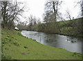
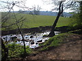
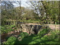
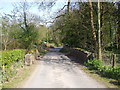
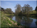
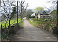
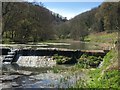
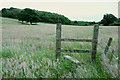
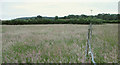
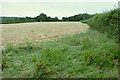
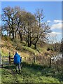
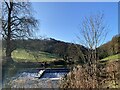
Michaelston-le-Pit and Leckwith Community is a civil parish located in the Vale of Glamorgan, immediately south west of Cardiff city. This area covers 8.3 km² and houses a population of around 1,445 people. The parish consists of two distinct villages, Michaelston-le-Pit and Leckwith, which retain a strong rural character despite their proximity to the capital. Michaelston-le-Pit sits near the confluence of two small streams that form the Cadoxton River, while Leckwith lies along the B4267 towards Llandough. Residents describe the location as a secluded place to live that remains accessible to the larger towns of Cardiff, Barry, and Penarth. The landscape features countryside, woodland, lovely walks, and seven lakes, offering views over the Bristol Channel and the surrounding valleys. You will find the area dominated by scattered farms and small house clusters rather than dense development. The name Michaelston-le-Pit likely derives from a clay pit and settlement established by the De Raneghs family after the Norman Conquest. Leckwith features a 16th-century Grade II listed stone bridge over the River Ely, which remains in use alongside a concrete replacement. Living in Michaelston-le-Pit and Leckwith Community means enjoying a historical atmosphere with lovely walks and great opportunities for dogs. The region remains fundamentally an agricultural area based on traditions tied to the Cardiff Castle manor and the Cwrt-yr-Ala estate. If you seek a balanced life between rural tranquillity and urban access, this parish offers a secluded environment with clear historical roots and practical connectivity to major population centres.
- Area Type
- Parish
- Area Size
- 8.3 km²
- Population
- Not available
- Population Density
- Not available
Demographics
The community within Michaelston-le-Pit and Leckwith Community reflects a distinctly mature population profile. The median age sits at 70 years, indicating that the area is suited largely to older residents or those seeking a quieter retirement environment. The demographic data categorises the most common age range under the label "Age: Total," confirming a general skew towards later life stages across the parish. Home ownership levels are exceptionally high at 88%, which suggests a population that has likely lived in their properties for long periods. This high rate of ownership indicates stability within the neighbourhood and a legacy of residents who have built their lives in the area. Regarding household composition and accommodation types, the available data categorises these under broad labels of "total" for both fields, confirming the aggregate nature of the statistics without detailed breakdowns for single-person versus family units. The predominant ethnic group and religious affiliations are listed simply as "total" in the records, meaning the specific breakdowns are not detailed in the current dataset. Despite the lack of granular diversity statistics, the high home ownership rate typically correlates with established communities where long-term residents form the core of social life. You can expect a neighbourhood where the majority of occupants own their homes outright or through mortgage in a setting defined by its rural history and agricultural past. The demographic reality points to a community built around stability, with an older population enjoying a high level of property security within the parish boundaries.
Household Size
Accommodation Type
Tenure
Ethnic Group
Religion
Household Composition
Age
Household Deprivation
NS-SEC
Explore more demographic insights in this area
Go to Demographics tabPlanning
Planning Constraints
- Flood RiskPremium
- Ramsar Wetland SitesPremium
- Area of Outstanding Natural BeautyPremium
- Protected Nature ReservePremium
- Protected WoodlandPremium
- Crime RiskPremium