Area Overview for CF62 8YG
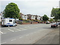
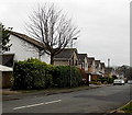
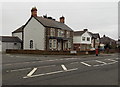
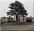
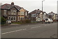
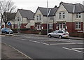
Photos of CF62 8YG


Area Information
CF62 8YG is a small residential postcode in the Vale of Glamorgan, Wales, nestled within the historic coastal town of Barry. With a population of 1,760, it represents a compact cluster of homes in an area shaped by both historical significance and modern practicality. Barry’s origins stretch back to Roman times, with its name possibly derived from the Welsh word *bar* meaning “hill” or from Saint Baruc, a sixth-century figure. The town’s identity was forged during the Industrial Revolution, when Barry Docks became the world’s largest coal-exporting port by 1913. Today, CF62 8YG lies within a community that balances its industrial past with coastal charm, offering proximity to Barry Island, a tidal island once separated from the mainland. Residents benefit from a mix of historical sites, such as Barry Castle ruins, and modern amenities like retail hubs and transport links. The area’s small size means a tight-knit community feel, with daily life influenced by its coastal location and nearby infrastructure.
- Area Type
- Postcode
- Area Size
- Not available
- Population
- 1760
- Population Density
- 4420 people/km²
CF62 8YG is characterised by a housing stock primarily composed of houses, with 57% of properties owned by residents. This contrasts with areas where flats or apartments dominate, suggesting a focus on family-friendly, single-unit homes. The relatively low population of 1,760 means the area is small, with limited housing options within the postcode itself. Buyers should consider nearby areas for a broader range of properties, though the existing stock reflects a traditional, settled community. The high proportion of owner-occupied homes indicates a preference for long-term investment, which may influence property values and market dynamics. For those seeking rental options, the smaller number of rental units could mean competition, but the overall market remains localised and community-driven.
House Prices in CF62 8YG
No properties found in this postcode.
Energy Efficiency in CF62 8YG
Living in CF62 8YG offers a blend of convenience and coastal appeal. The area’s proximity to retail hubs like Co-op Barry and Sainsburys Barry ensures daily essentials are within reach. For leisure, the Barry Waterfront Ferry Terminal and Penarth Pier provide access to the Bristol Channel, while rail stations connect to Barry Island and beyond. The nearby Barry Island Pleasure Park, though not explicitly named in the data, is a historic attraction that may be within practical reach, offering family-friendly activities. The area’s small size means amenities are compact but functional, with the added benefit of being near the coast. The presence of multiple ferry, rail, and retail options enhances daily life, making it easy to balance work, leisure, and travel needs.
Amenities
Schools
The nearest school to CF62 8YG is St Helen’s R.C. Junior School, which serves the local community. While no Ofsted rating is provided in the data, the presence of a junior school suggests the area is well-served for primary education. Families with children may benefit from the proximity to this institution, though the absence of secondary schools or additional educational facilities within the postcode means parents might need to look further afield for comprehensive schooling. The mix of school types is limited in this area, but the availability of a junior school indicates a focus on early education, which is a key consideration for families prioritising primary schooling.
| Rank | School | Type | Entry gender | Ages |
|---|
Explore more schools in this area
Go to Schools tabDemographics
The population of CF62 8YG is 1,760, with a median age of 47 and the majority of residents falling within the 30–64 age range. This suggests a community of middle-aged adults, likely including families and professionals. Home ownership stands at 57%, indicating a mix of owner-occupied properties and rental units. The predominant accommodation type is houses, which is typical for this small residential area. The dominant ethnic group is White, reflecting the broader demographic patterns of the region. While no specific data on deprivation is provided, the age profile and home ownership rate suggest a stable, established community with a focus on long-term residency. The absence of detailed diversity statistics means the area’s cultural composition remains less defined in the data, though it aligns with wider Welsh trends.
Household Size
Accommodation Type
Tenure
Ethnic Group
Religion
Household Composition
Age
Household Deprivation
NS-SEC
Explore more demographic insights in this area
Go to Demographics tabPlanning
Planning Constraints
- Flood RiskPremium
- Ramsar Wetland SitesPremium
- Area of Outstanding Natural BeautyPremium
- Protected Nature ReservePremium
- Protected WoodlandPremium
- Crime RiskPremium