Area Overview for SA3 4SZ
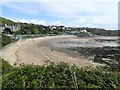
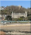
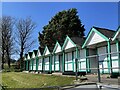
Photos of SA3 4SZ


Area Information
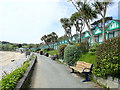
Living in SA3 4SZ means residing within a compact residential cluster covering just 1.4 hectares. This small postcode area contains a population of 1,649 residents, creating a tight-knit environment with a population density of 999 people per square kilometre. You will find that daily life revolves around proximity, with every service within a short walk or drive. The house serves as the dominant accommodation type, reflecting a community built for families rather than urban高密度 housing. You step outside to see neighbours and green spaces almost immediately, fostering a sense of familiarity that is hard to replicate in larger cities. The area sits in Wales, offering a lifestyle distinct from the English estates often seen elsewhere. Because of its small footprint, privacy can be both a gift and a challenge, depending on where you stand. You benefit from a setting that feels established rather than volatile. The cluster is well-integrated into the wider Mumbles and Swansea landscape, yet it maintains its own distinct character. When you consider buying homes in this postcode, you are entering a market defined by limited space and high demand from those seeking稳定性 over scale. The environment suits people who value quiet streets and local knowledge over the anonymity of a metropolis. Overall, this location offers a practical arrangement for those who prioritise a settled rhythm. The resident base reflects stability, with high home ownership driving a culture of long-term commitment. You do not face the chaos of dense urban sprawl here. Instead, you enjoy a controlled environment where the community knows the roads and the people. This makes SA3 4SZ an attractive option for anyone seeking a grounded lifestyle in South Wales without the pressure of a large town centre.
- Area Type
- Postcode
- Area Size
- 1.4 hectares
- Population
- 1649
- Population Density
- 999 people/km²
The property market in SA3 4SZ is defined by a clear dominance of owner-occupied housing. With 76% of residents owning their homes, this postcode operates as a traditional residential zone rather than a rental hub. You will find that the buying pool consists largely of committed owners who have purchased their current properties. This high ownership rate contrasts sharply with areas where landlords dominate the landscape. Consequently, the housing stock remains stable, with fewer speculative turnover cycles creating disruption for neighbours. Homes in SA3 4SZ are primarily houses, catering to families and households seeking gardens and private spaces. The area description specifies a residential cluster, implying a cohesive layout of existing properties rather than large-scale developments. This architecture type commands a different market value than apartments, typically reflecting higher price points per square metre. Buyers looking at this small area will find limited inventory but high demand from those prioritising home ownership. The market dynamics favour cash buyers or those with strong mortgages rather than developers seeking quick flips. This specific postcode covers a mere 1.4 hectares, meaning competition for suitable properties can be fierce. You should expect to act quickly if you find a home that meets your criteria. The lack of rental inventory suggests that if you are looking to invest in a buy-to-let strategy, the yield may be lower, but the long-term stability is higher. Residents enjoy the security of paying off a mortgage in a neighbourhood where neighbours have invested in their own homes. The accommodation type remains consistent, offering a predictable character. When viewing homes in this area, focus on condition and location within the tight cluster, as expansion is rarely possible in such a confined space.
House Prices in SA3 4SZ
Showing 9 properties
| Address | Type | Beds | Baths | Last Sale Price | Last Sale Date | |
|---|---|---|---|---|---|---|
| 5 Linkside, Langland, Swansea, SA3 4SZ | Land | 4 | 2 | £430,000 | Jul 2017 | |
| 14 Linkside, Langland, Swansea, SA3 4SZ | house | - | - | £317,500 | Jul 2014 | |
| 1 Linkside, Langland, Swansea, SA3 4SZ | house | - | - | £250,000 | Dec 2008 | |
| 3 Linkside, Langland, Swansea, SA3 4SZ | Detached | - | - | £345,000 | May 2006 | |
| 12 Linkside, Langland, Swansea, SA3 4SZ | Semi-detached | - | - | £118,000 | Sep 1998 | |
| 4 Linkside, Langland, Swansea, SA3 4SZ | Detached | 3 | 1 | - | - | |
| 6 Linkside, Langland, Swansea, SA3 4SZ | house | - | - | - | - | |
| 7 Linkside, Langland, Swansea, SA3 4SZ | house | - | - | - | - | |
| 2 Linkside, Langland, Swansea, SA3 4SZ | Semi-detached | - | - | - | - |
Energy Efficiency in SA3 4SZ
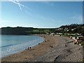
Your daily routine in SA3 4SZ is supported by a network of amenities located just outside the immediate 1.4 hectares. You are surrounded by retail options that serve varied needs. The M&S Mumbles store offers fashion and household essentials, while the Tesco Newton and Co-op Swansea provide extensive grocery choices. These three retailers give you access to quality shopping without needing to travel deep into the city. Fresh produce, daily staples, and clothing brands are all reachable within a short drive or a scenic bus ride along the coastal route. For leisure and travel, the area offers convenient access to two airports and a ferry terminal. Swansea Airport sits nearby, facilitating both light commercial and private flights. Its presence adds value for residents who require occasional international travel or rapid domestic transit. Further coastal expansion includes the Swansea Queens Dock Ferry Terminal. You might use this terminal for short seaside trips or connections across the Bristol Channel. Additionally, you have two railway stations to consider: Swansea Railway Station and Gowerton Railway Station. These links integrate you into the national transport web, allowing easy commutes to major employment hubs. Living in this area means balancing a quiet residential life with quick access to broader opportunities. The 1649 residents share this proximity to world-class amenities. You can enjoy the tranquillity of your home base while treating city-centre services as a quick outing on weekends. The combination of supermarkets, rail, airports, and ferry services ensures you never feel isolated despite the rural feel of the postcode. When planning your week, you have the flexibility to choose between a quiet morning and an active day out with family. The character of the surrounding facilities supports a balanced lifestyle that does not compromise convenience for peace.
Amenities
Schools
| Rank | School | Type | Entry gender | Ages |
|---|
Explore more schools in this area
Go to Schools tabDemographics
The community in SA3 4SZ skews towards middle-aged residents, with a median age of 47 years. You will find that adults aged between 30 and 64 years form the most common age range, creating a well-established residential demographic. This age profile suggests stability over rapid turnover, which often appeals to those seeking a quiet neighbourhood. Home ownership stands at an impressive 76%, indicating that the vast majority of these residents have purchased their properties rather than renting. This high rate of ownership implies a community invested in the long term. Accommodation within this postcode consists predominantly of houses, aligning with the age profile and ownership data. You will rarely encounter high-rise flats or modern apartment blocks here. The residential stock reflects a traditional preference for garden homes and detached or semi-detached properties. While specific deprivation data is not quantified in the current records, the high home ownership suggests a community with significant financial security and footedness in the local estate. This demographic mix supports local businesses that cater to families rather than transient commuter students or young professionals. The predominant ethnic group is White, which contributes to the homogenous feel of the cluster. You may notice fewer ethnic diversities compared to larger urban centres near Swansea city. This demographic consistency often fosters a strong sense of local identity and shared history among neighbours. For homebuyers, this means engaging with a community that values tradition and continuity. The situation supports a predictable social environment where long-term residents hold significant influence. You are likely to meet neighbours who have lived here for decades, sharing stories across generations within the same streets.
Household Size
Accommodation Type
Tenure
Ethnic Group
Religion
Household Composition
Age
Household Deprivation
NS-SEC
Explore more demographic insights in this area
Go to Demographics tabPlanning
Planning Constraints
- Flood RiskPremium
- Ramsar Wetland SitesPremium
- Area of Outstanding Natural BeautyPremium
- Protected Nature ReservePremium
- Protected WoodlandPremium
- Crime RiskPremium