Area Overview for SA3 4QP
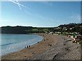
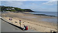
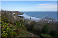
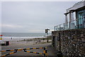
Photos of SA3 4QP
Area Information
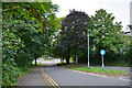
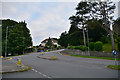
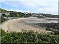
Living in SA3 4QP means settling into a specific residential cluster covering just 3.2 hectares. This small area supports a population of 1,649 people, creating a close-knit community with a population density of 999 people per square kilometre. The location sits within Wales, offering a defined environment for those seeking a smaller footprint. Daily life revolves around this compact cluster where proximity between neighbours is a defining feature. The area functions as a self-contained pocket of the wider region, distinct from the sprawling suburbs nearby. You will find that life here is characterised by immediate access to fellow residents rather than wide open spaces. The postcode encompasses a tight group of properties where the head count remains steady. This concentration creates a village-like atmosphere despite the urban context of Swansea. Residents experience a sense of locality where everyone knows the boundaries of their immediate surroundings. The area offers a straightforward living situation without the complexity of larger developments. Your daily routine involves navigating this small zone with efficiency.
- Area Type
- Postcode
- Area Size
- 3.2 hectares
- Population
- 1649
- Population Density
- 999 people/km²
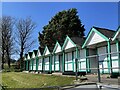
Homes in SA3 4QP are defined by a strong owner-occupier culture, with 76% of residents owning their properties outright or with a mortgage. This figure indicates that the local property market is driven by permanent residents seeking equity rather than transient tenants or investors. The accommodation type is heavily skewed towards houses, meaning you will find primarily detached, semi-detached, or terraced homes rather than flats or apartments. This housing stock suits families and individuals who value garden space and traditional layouts. The small area size of 3.2 hectares limits the volume of available properties, making each listing significant for local buyers. Given the old-style ownership levels and lack of rental influx, finding a rental here is unlikely compared to the purchase route. You will encounter a market where sellers often aim for quick sales due to local stability needs. Prices reflect the demand from those wishing to enter this exclusive cluster of properties. The inventory is finite, leading to competitive conditions when specific houses come up for sale. Buyers should focus on the specific condition of houses within this postcode rather than expecting a wide range of choices.
House Prices in SA3 4QP
Showing 20 properties
| Address | Type | Beds | Baths | Last Sale Price | Last Sale Date | |
|---|---|---|---|---|---|---|
| 9 Langland Bay Road, Langland, Swansea, SA3 4QP | Detached | - | - | £1,225,000 | Dec 2009 | |
| 26 Langland Bay Road, Langland, Swansea, SA3 4QP | Detached | - | - | £499,000 | May 2006 | |
| 54 Langland Bay Road, Langland, Swansea, SA3 4QP | Detached | 2 | 2 | - | - | |
| 24 Langland Bay Road, Langland, Swansea, SA3 4QP | Retail | - | - | - | - | |
| Flat 5, Ael Y Don, 13 Langland Bay Road, Langland, Swansea, SA3 4QP | Flat | 2 | 2 | - | - | |
| Former Flat 6, Ael Y Don, 13 Langland Bay Road, Langland, Swansea, SA3 4QP | Flat | - | - | - | - | |
| Flat 3, Ael Y Don, 13 Langland Bay Road, Langland, Swansea, SA3 4QP | Flat | - | - | - | - | |
| Flat 4, Ael Y Don, 13 Langland Bay Road, Langland, Swansea, SA3 4QP | Flat | - | - | - | - | |
| Surfside Cafe, Alma Road, Langland, Swansea, SA3 4QP | Restaurant | - | - | - | - | |
| Rnli, Langland Lifeguard Inshore Rescue Station, Alma Road, Langland, Swansea, SA3 4QP | commercial | - | - | - | - |
Energy Efficiency in SA3 4QP
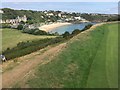
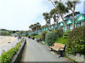
Your lifestyle in SA3 4QP benefits from a practical array of amenities reachable within a short drive. Retail options include M&S Mumbles, Tesco Newton, and Co-op Swansea, ensuring you have shopping days without the need to travel far. These specific venues cater to everyday needs from groceries to clothing and household goods. For leisure and travel, you have access to Swansea Airport and the ferry terminal at Swansea Queens Dock, offering diverse transport modes. Rail users can reach Swansea Railway Station or Gowerton Railway Station for seasonal or regular train journeys. While the area lacks large parks or leisure centres within the immediate 3.2 hectares, the surrounding region offers these facilities. The presence of shops near Newton and Mumbles means you can run errands close to home. Dining and socialising extend to the nearby towns like Mumbles, providing a wider selection than the small postcode alone. This arrangement allows for convenience without isolation. You can combine local privacy with easy access to town centres when necessary.
Amenities
Schools
| Rank | School | Type | Entry gender | Ages |
|---|
Explore more schools in this area
Go to Schools tabDemographics
The community in SA3 4QP reflects a mature demographic profile with a median age of 47 years. Most residents fall within the adult age range of 30 to 64 years, suggesting a population settled in their careers and families. This age distribution indicates a stable neighbourhood where long-term residents form the backbone of the community. You will find that house ownership is a dominant trait, with 76% of the population owning their homes. This high ownership rate demonstrates significant investment in the locality and a preference for stability over renting. The predominant accommodation type consists of houses, providing spacious living environments suitable for families or larger households. Ethnically, the area is predominantly White, reflecting a traditional community structure. This demographic makeup suggests a homogeneous environment where shared cultural values may run deep. The concentration of adults in the middle age bracket implies that parents and empty nesters are the primary demographic groups. You can expect a quiet domestic setting where life revolves around established routines. The low presence of young children or older pensioners compared to other brackets shapes the social fabric.
Household Size
Accommodation Type
Tenure
Ethnic Group
Religion
Household Composition
Age
Household Deprivation
NS-SEC
Explore more demographic insights in this area
Go to Demographics tabPlanning
Planning Constraints
- Flood RiskPremium
- Ramsar Wetland SitesPremium
- Area of Outstanding Natural BeautyPremium
- Protected Nature ReservePremium
- Protected WoodlandPremium
- Crime RiskPremium