Area Overview for SA3 3BX
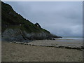
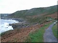
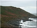
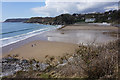
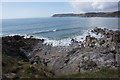
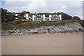
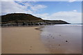
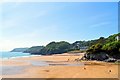
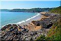
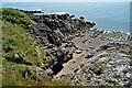
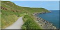
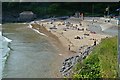
Photos of SA3 3BX
Area Information
Living in SA3 3BX offers a contained residential experience within the Swansea postcode district. This specific cluster holds a population of 1,474 residents, creating an intimate neighbourhood feel rather than the sprawling anonymity found in larger urban zones. The density stands at 476 people per square kilometre, which suggests a tightly knit community where neighbours are likely to know each other. Located in Wales, this postcode represents a small residential group ideal for those seeking quiet streets without complete isolation. The area functions best for individuals who value proximity to family or work, as the total population size limits the scale of spontaneous social events but ensures a stable, established environment. You will find a settlement that has settled into a routine, avoiding the transient nature of new developments. The compact size means that daily travel distances are short, and the sense of place is defined by its defined boundaries rather than by large commercial centres. It is a location for stability, where the local rhythm is dictated by the needs of the roughly 1,500 people who make it their daily home.
- Area Type
- Postcode
- Area Size
- Not available
- Population
- 1474
- Population Density
- 476 people/km²
The property market in SA3 3BX is characterised by a strong owner-occupier presence, with 83% of homes in the area owned by their residents. This starkly contrasts with rental-heavy hotspot cities where transient tenants move frequently. Because the accommodation type consists of houses, you will find a stock designed for families or couples who value space and privacy over the compact living found in flats. This ownership level suggests that prices may rise steadily rather than fluctuate wildly with the rental market. Buyers looking at this small postcode area should expect a stable market where properties often stay on the local scene for generations. The house-dominated stock implies that sound insulation and outdoor space are standard expectations rather than luxuries. If you are considering purchasing homes in SA3 3BX, the high ownership rate means that the existing residents are likely to be relatively wealthy or financially secure enough to have stayed put. This environment is distinct from a student cluster or a commuter hub dominated by temporary rentals.
House Prices in SA3 3BX
No properties found in this postcode.
Energy Efficiency in SA3 3BX
Residents of SA3 3BX enjoy access to several key amenities within a practical driving distance. For shopping needs, there are five nearby stores, including a Co-op Swansea, a Spar, and an M&S Mumbles location. These high-street names ensure that your weekly food shops and larger purchases are easily accessible without crossing the city limits. Transport links are varied and robust, with two railway stations at your disposal: the Gowerton Railway Station and the Swansea Railway Station. Furthermore, two airports land in the vicinity, both listed as Swansea Airport, providing easy regional travel options. For those who prefer sea travel, the Swansea Queens Dock Ferry Terminal offers a direct link across the water. These five categories of amenities mean that you can handle retail, rail, air, and maritime travel from close quarters. The presence of these specific venues ensures that the area is not isolated despite its rural postcode feel. You have the convenience of supermarkets, train lines, and airports all within a reasonable commute.
Amenities
Schools
For families looking for education options near SA3 3BX, two specific institutions stand out as the primary choices. Bishopston Comprehensive School and Craig Y Nos School are the nearest educational facilities listed for the local area. Both schools are designated as "other" types within the available data, which categorises them generally as secondary institutions rather than primary or special schools, though specific ratings are not provided in the current records. The presence of these two schools suggests that residents have options within the Swansea local education authority network. You will need to contact the schools directly for the latest Ofsted ratings, as the data does not supply them. The mix of school types indicates that you cannot rely solely on primary education within the immediate vicinity. Families with older children will find these institutions relevant, while those with younger children may look slightly further afield for infant schools. The location provides a practical catchment area for students in the Mumbles and Swansea annual zones.
| Rank | School | Type | Entry gender | Ages |
|---|
Explore more schools in this area
Go to Schools tabDemographics
The community in SA3 3BX is defined by a mature demographic profile, with a median age of 47 years. The most common age range consists of adults between 30 and 64 years, indicating a population primarily made up of working-age individuals and those approaching retirement. This age structure suggests a quiet environment where young children are less prevalent than in family-dominated zones. Home ownership is highly prevalent, with 83% of residents owning their property outright or with a mortgage. This high figure indicates a settled population that has likely lived in their homes for many years. The accommodation type is almost exclusively houses, reflecting the preference for larger dwellings suitable for this age group. The predominant ethnic group is White, which aligns with the broader national trend for this part of Wales. You can expect a community where long-term residents form the backbone of social interaction. The lack of young families in the data points to a neighbourhood better suited for adults seeking peace rather than a bustling hub of nursery activity.
Household Size
Accommodation Type
Tenure
Ethnic Group
Religion
Household Composition
Age
Household Deprivation
NS-SEC
Explore more demographic insights in this area
Go to Demographics tabPlanning
Planning Constraints
- Flood RiskPremium
- Ramsar Wetland SitesPremium
- Area of Outstanding Natural BeautyPremium
- Protected Nature ReservePremium
- Protected WoodlandPremium
- Crime RiskPremium