Area Overview for SA1 6DX
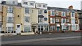
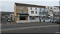
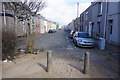
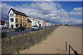
Photos of SA1 6DX


Area Information
Living in SA1 6DX means residing within a specific postcode area that covers a small residential cluster in Wales. This community has a population of 1522 people, creating a quiet and intimate neighbourhood environment. You will find this area distinct from larger urban centres because it offers a residential focus without the density of a big city. The location is situated where practical convenience meets a lower volume of residents, which often translates to less traffic and noise during daily routines. When you consider homes in SA1 6DX, you are entering a setting defined by its manageable scale. The area functions as a stable part of the Swansea landscape, providing a backdrop for those who prefer a contained living environment over sprawling suburbs. Daily life here centres on the immediate surroundings of this small cluster, yet you remain well connected to wider transport and retail networks. The district benefits from its position relative to nearby towns, allowing residents to access essential services without travelling extreme distances. This postcode represents a modest footprint within the broader Swansea geography. It attracts individuals looking for a settled home rather than a large estate or city block. The combination of limited population size and focused housing stock creates a predictable living rhythm. You can expect a neighbourhood where community interactions often feel more personal due to the smaller number of households. Prospective buyers value this locality for its straightforward nature and its role as a quiet anchor in the region.
- Area Type
- Postcode
- Area Size
- Not available
- Population
- 1522
- Population Density
- 3993 people/km²
Looking at the property market in SA1 6DX, you are entering a sector defined by established housing stock and moderate ownership levels. Houses form the primary accommodation type, confirming that this postcode is not dominated by high-rise apartments or private rentals. This structure is typical for areas that grew during earlier periods of expansion before post-war council tenure became more prevalent. With home ownership at 47%, this area represents a mixed market where buyer interest and seller demand coexist. Roughly half of the residents are owners, which suggests that the area is not purely speculative or transient. This balance often stabilises prices and prevents the rapid turnover typical of pure investment hubs. You will likely encounter properties that have been cared for over multiple years, contributing to the condition and character of the streets. Prospective buyers considering homes in SA1 6DX should note that the stock is not uniform. The prevalence of houses implies a mix of detached, semi-detached, and possibly terraced properties depending on the specific street layout of this small cluster. The property market here is not driven by short-term letting agencies but rather by local families and professionals seeking a base. The small population of 1522 means inventory levels may be low during peak selling seasons. Competition for specific properties can arise quickly because the total number of available homes is restricted. If you are looking to purchase, you must act decisively to secure a property of interest, as the supply within this postcode area is naturally limited by its size and the type of dwellings available.
House Prices in SA1 6DX
No properties found in this postcode.
Energy Efficiency in SA1 6DX
Your daily lifestyle in SA1 6DX is shaped by a network of amenities that extends just beyond the immediate residential cluster to Swansea and surrounding towns. You have access to five major retail options nearby, including Sainsburys Swansea, Tesco Swansea, and Co-op Swansea. These supermarkets provide you with all the groceries and household essentials within a short drive from your door. Transport connectivity is a highlight for residents who value flexibility. There are four rail stations within practical reach, including Swansea Railway Station, Gowerton Railway Station, and Llansamlet Railway Station. These stations offer direct links to the wider railway network, allowing you to commute to Cardiff, Bristol, or other key destinations. You can plan journeys with the certainty of frequent service from these designated stops. Air travel is also accessible, with two airports noted in the vicinity: Swansea Airport. This proximity gives you options for short-haul flights for holidays or business trips without needing to travel to a major international hub like Bristol or Heathrow. Additionally, the Swansea Queens Dock Ferry Terminal is available one ferry stop away, providing a direct link to West Wales and England. These amenities create a convenient sphere of influence around SA1 6DX. You do not need to travel far to shop by the hour. The presence of multiple transport nodes ensures that you are never isolated. Daily errands take minutes, while longer trips are manageable from the railway or air terminals. This blend of local nature and regional access defines the character of living in this postcode.
Amenities
Schools
| Rank | School | Type | Entry gender | Ages |
|---|
Explore more schools in this area
Go to Schools tabDemographics
The community in SA1 6DX reflects a mature profile with significant stability. You will find that adults between 30 and 64 years represent the most common age range within this postcode. The median age is 47, indicating that older families and established residents form the core of the population. This demographic pattern suggests a neighbourhood where life stages are less volatile and more settled. Home ownership stands at 47% in this area, meaning nearly half of the residents own their property outright or through a mortgage. The remaining households likely function through renting or living with relatives. Houses are the predominant accommodation type, which aligns with the preference for single-family or terraced living found in older Welsh settlements. This housing style supports garden space and individual privacy, catering to those who value private outdoor areas over communal flats. The predominant ethnic group is White, reflecting the traditional makeup of many rural and semi-rural clusters in Wales. This homogeneity often contributes to a strong sense of local identity and shared community history. You will encounter neighbours who have likely been part of the local fabric for many years. The data shows a clear absence of significant youth dependency, as the population skew towards middle age reduces the proportion of school-age children compared to younger suburbs. For those researching schools near SA1 6DX, the local demographic suggests a reliance on broader regional facilities rather than a high concentration of young dependents within this specific cluster. The stability of the age profile and the high rate of home ownership indicate a neighbourhood built for long-term residence. Buyers looking at these figures see an area characterised by maturity and a steady, non-transient resident base.
Household Size
Accommodation Type
Tenure
Ethnic Group
Religion
Household Composition
Age
Household Deprivation
NS-SEC
Explore more demographic insights in this area
Go to Demographics tabPlanning
Planning Constraints
- Flood RiskPremium
- Ramsar Wetland SitesPremium
- Area of Outstanding Natural BeautyPremium
- Protected Nature ReservePremium
- Protected WoodlandPremium
- Crime RiskPremium