Area Overview for Llanrhidian Higher Community
Photos of Llanrhidian Higher Community
Area Information
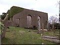
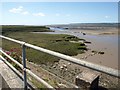
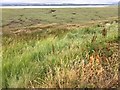
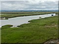
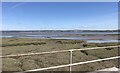
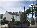
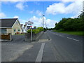
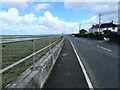
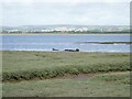
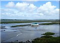
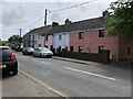
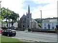
Living in Llanrhidian Higher Community offers a life defined by rural tranquillity and deep historical roots on the Gower Peninsula. This civil parish encompasses a significant area of 19.0 km², spreading across upland North Gower to include connected settlements such as Penclawdd, Crofty, Llanmorlais, Blue Anchor, and Wernffrwd. The population recorded at the 2011 census reached 5,218 residents, creating a distinct sense of place within the broader Swansea region. You are situated in an area defined by its elected community council, with coordinates placing you approximately at 51.63°N 4.11°W. Your daily environment features dramatic landscapes, including marshes, sands, limestone cliffs, and village greens that have shaped the locality for centuries. History permeates the fabric of Llanrhidian Higher. The area was first associated with a Christian settlement dedicated to the Celtic saint Rhidian, suggesting a monastic cell may have existed in the early medieval period. You will find landmarks such as the Church of St. Rhidian and St. Illtud, which dates from the 12th century and rests upon a unique 10th-century tomb cover known as the Leper Stone. Agricultural prosperity in the 19th century drove the local economy through sheep farming, fishing, and milling. Today, the landscape retains a blend of farming, mosses, marshes, and limestone cliffs. Research indicates the area contains an AONB designation, alongside protected nature reserves and woodland. You live in a valley historically tied to the medieval Cwmwd of Gwyr. While the scenery is described as vibrant and welcoming by visitors, the character remains firmly rural. The parish includes conservation areas protecting features like lime kilns and prehistoric standing stones. This setting provides a retreat from urban pace but requires adaptation to a slower, agriculture-focused lifestyle.
- Area Type
- Parish
- Area Size
- 19.0 km²
- Population
- Not available
- Population Density
- Not available
Demographics
The community profile of Llanrhidian Higher presents a clear picture of a mature, established locality. Data shows the median age for residents is 70, indicating a population heavily weighted towards older adults. The most common age category listed is simply Age: Total, suggesting broad categorisation rather than granular youth or working-age segments. Home ownership is extremely high, with 82% of households owning their property free of rent. This figure underscores the stability of the resident base, pointing to a neighbourhood where people have settled permanently rather than moving frequently. Household composition figures are not numerically detailed in the available records, preventing a precise breakdown of single-person homes versus families. You should assume the data reflects a standard distribution for rural Welsh parishes without specific sub-stats. Accommodation types are also aggregated under total figures, meaning you cannot distinguish between semi-detached, terraced, or detached housing counts from this dataset. Predominant ethnic groups and religious affiliations are similarly recorded as totals, lacking specific percentages or denominational splits. All recorded metrics fall under a total or general category. Presented deprivation data is not included in the provided statistics. Consequently, you must evaluate quality of life based on the physical environment and connectivity rather than economic indicators. The high home ownership rate of 82% suggests financial security among the populace. With a median age of 70, services and amenities are likely geared towards senior needs. You live in an area where intergenerational mixing may be lower than in urban centres. The demographic stiffness implies a quiet, predictable community rather than a dynamic, shifting population. Buyers looking for young families might find the high median age limiting, while those seeking a retirement or semi-retirement environment will find the 70-year median age aligns closely with their expectations.
Household Size
Accommodation Type
Tenure
Ethnic Group
Religion
Household Composition
Age
Household Deprivation
NS-SEC
Explore more demographic insights in this area
Go to Demographics tabPlanning
Planning Constraints
- Flood RiskPremium
- Ramsar Wetland SitesPremium
- Area of Outstanding Natural BeautyPremium
- Protected Nature ReservePremium
- Protected WoodlandPremium
- Crime RiskPremium