Area Overview for Tylorstown Community
Photos of Tylorstown Community
Area Information
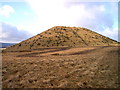
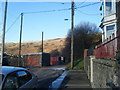
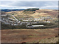
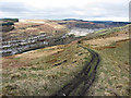
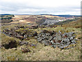
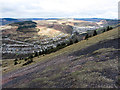
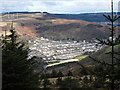
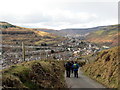
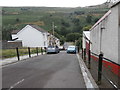
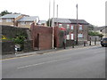
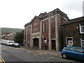
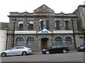
Tylorstown Community is a civil parish situated in the Rhondda valley within Rhondda Cynon Taf, Wales. This 5.9 km² neighbourhood sits close to neighbouring towns including Blaenllechau, Ferndale, Penrhys, Pontygwaith and Stanleytown. The area carries a deep historical significance rooted in the coal mining era that defined the valley. London geologist Alfred Tylor purchased mineral rights from Pendyrus Farm in 1872 and opened Pendyrus Colliery shortly after. Workers housing that emerged from this industry eventually became known as Tylor's Town. Your daily life here is shaped by distinctive landmarks such as the Tylorstown Welfare Hall and Holy Trinity Church. The hall, constructed in 1933 in French Baroque style, stands as the last remaining miners' institute in the Rhondda Valley. Recent funding will see significant renovation work commence in 2026. Holy Trinity Church features a five-light west window and stained glass created by monks from Prinknash Abbey. The Rhondda by-pass opened in December 2006 at a cost of £98m to reduce congestion for residents. Transport links rely heavily on this road now that the local passenger rail line closed in 1964 during the Beeching Axe cuts. You live in a space where past industrial might meets ongoing community regeneration efforts through sites like the Rhondda Fach Sports Centre.
- Area Type
- Parish
- Area Size
- 5.9 km²
- Population
- Not available
- Population Density
- Not available
Demographics
The community in Tylorstown Community presents a distinct age profile with a median age of 70 years. The most common age group recorded for the total population is full adults. Housing ownership policies result in 55% of homes being owner-occupied properties. The area contains a mix of household compositions though specific breakdowns for family sizes or single occupants are not detailed in current records. Accommodation types vary across the parish but absolute figures for detached, semi-detached, or terraced homes are not included in the provided dataset. Ethical composition and religious affiliation figures for the total population are not available for publication. Life in Tylorstown Community reflects the legacy of a mining heritage that began in the 1870s when Alfredd Tylor opened Pendyrus Colliery. The high median age suggests a resident base that has matured alongside the valley's transition from heavy industry to modern services. You can expect a quiet atmosphere typical of villages in the Rhondda valley where many families have lived for generations. The 55% homeownership rate indicates a stable residential market where long-term residents own their residences rather than renting. What remains certain is that Tylorstown Community functions as a cohesive parish village within the broader Rhondda Cynon Taf county borough structure.
Household Size
Accommodation Type
Tenure
Ethnic Group
Religion
Household Composition
Age
Household Deprivation
NS-SEC
Explore more demographic insights in this area
Go to Demographics tabPlanning
Planning Constraints
- Flood RiskPremium
- Ramsar Wetland SitesPremium
- Area of Outstanding Natural BeautyPremium
- Protected Nature ReservePremium
- Protected WoodlandPremium
- Crime RiskPremium