Area Overview for Hirwaun Community
Photos of Hirwaun Community

Area Information
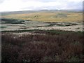
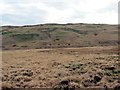
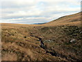
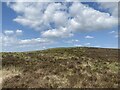
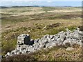
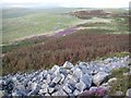
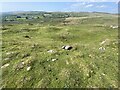
Hirwaun Community sits at the northern end of the Cynon Valley in the County Borough of Rhondda Cynon Taf, approximately 4 miles northwest of Aberdare. This civil parish covers 59.1 km² and defines an industrial village that grew to house workers from the Hirwaun Ironworks on the southern bank of the River Cynon. The area runs from the river valley floor up to the uplands of Hirwaun Common and Craig-y-Llyn, which reaches 1,969 feet. The village proper developed around the ironworks founded in 1757 by John Mayberry, a site that held the distinction of being the first coke-fired furnace in South Wales. You find particular interest in the historic architecture spanning from the 18th century to the present day. This includes the ruined Crawshay's Tower, built around 1848, and St Lleurwg's Church, consecrated in 1858. Daily life here centres on the village green and the surrounding historic chapels that date back to the 1820s. The parish boundary with Penderyn in Breconshire follows the River Cynon. Your daily commute likely involves the A4067 turnpike road, constructed around 1800, or local routes connecting to Glynneath and Merthyr. The location offers a mix of industrial heritage and green space, making it a distinctive choice within South Wales. Historic landmarks like the site of the Hirwaun Ironworks and the war memorial unveiled in 1924 form the backdrop for residential life. The area maintains a clear sense of identity rooted in its iron and coal working past, yet the current population of roughly 1,812 people creates a close-knit environment where history and modern living intersect directly.
- Area Type
- Parish
- Area Size
- 59.1 km²
- Population
- Not available
- Population Density
- Not available
Demographics
The community profile in Hirwaun Community reveals a settled population with a median age of 70 years. This demographic indicates an area where older residents form the core of the local population structure. The most common age range reflects this mature settlement pattern, suggesting a neighbourhood where families often include elderly relatives or retirees. You will find that 82% of residents own their homes, a figure that stands out as significantly high compared to national averages in many parts of the country. This level of ownership suggests a stable, long-term community fabric rather than a market dominated by short-term rentals or investment properties. Household composition data confirms that the total household make-up aligns with the older demographic, pointing towards smaller households or single-occupancy dwellings. The predominant ethnic group is defined by the total population statistics, reflecting the established character of the area. Religion and accommodation types across the parish mirror these stable, owner-occupied trends. The area does not show the transient dynamics of a student town or a major commuter hub with high rental turnover. Instead, the social fabric remains consistent, with ownership levels providing a sense of permanence. For a prospective buyer, the fact that such a large majority live in their own homes implies strong local investment in the village. This stability means that changes to the neighbourhood tend to be gradual rather than sudden.
Household Size
Accommodation Type
Tenure
Ethnic Group
Religion
Household Composition
Age
Household Deprivation
NS-SEC
Explore more demographic insights in this area
Go to Demographics tabPlanning
Planning Constraints
- Flood RiskPremium
- Ramsar Wetland SitesPremium
- Area of Outstanding Natural BeautyPremium
- Protected Nature ReservePremium
- Protected WoodlandPremium
- Crime RiskPremium